
Primary inflows Catchment area 27,700 km² Surface elevation 3,686 m Inflow source Desaguadero River | Surface area 1,000 km (390 sq mi) Area 3,191 km² Mean depth 2.4 m | |
 | ||
Lake poop in bolivia is disappearing
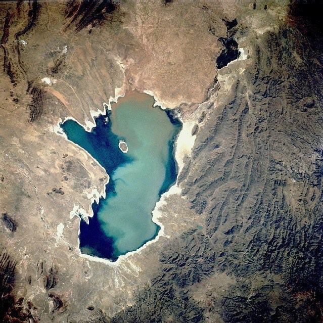
Lake Poopó (Spanish: Lago Poopó) was a large saline lake located in a shallow depression in the Altiplano Mountains in Oruro Department, Bolivia, at an altitude of approximately 3,700 metres (12,100 ft). Because the lake was long and wide (90 by 32 kilometres (56 by 20 mi)), it made up the eastern half of the department, known as a mining region in southwest Bolivia. The permanent part of the lake body covered approximately 1,000 square kilometres (390 sq mi) and it was the second-largest lake in the country. The lake received most of its water from the Desaguadero River, which flows from Lake Titicaca at the north end of the Altiplano. Since the lake lacked any major outlet and had a mean depth of less than 3 metres (9.8 feet), the surface area differed greatly on a seasonal basis.
Contents
- Lake poop in bolivia is disappearing
- Map of PoopC3B3 Lake Bolivia
- Archaeological evidence
- Lake dynamics
- Salinity and geology
- Mining and heavy metals
- Flora and fauna
- References
Map of Poop%C3%B3 Lake, Bolivia
In 2002 the lake was designated as a site for conservation under the Ramsar Convention. By December 2015, the lake had completely dried up, leaving only a few marshy areas. Although the lake has dried up completely a couple of times in the past, it does not appear that it will recover this time. Suggested causes of the decline are the melting of the Andes glaciers and loss of their waters, because of a drought due to climate change, as well as continued diversion of water for mining and agriculture.
Archaeological evidence
Archaeological investigations conducted by the San Andrés University of La Paz, Bolivia, shows the influence of the Wankarani culture in the Poopó area. Complex central urban areas, such as villages and towns, were developed that expanded into the Poopó basin during the Late Formative period, (200 BCE – 200 CE), probably in conjunction with changing patterns of agriculture. Herders and the life style of llama caravan merchants coexisted with more sedentary farmers in a harmonious system of exchange of goods and services.
Other investigators examining the following period, the Early Regional Developments (approx. 300 - 900 CE), have concluded that the size of the inhabited areas increased. The South Poopó inhabitants developed a unique style of ceramics style with triangular spirals. The east portion of the lake has evidence of an important Tiwanaku enclave, with ceramic styles from the core Titicaca area and surrounding styles, demonstrating the interactions between different peoples in the area.
Lake dynamics
The main inlet of Lake Poopó (roughly 92% of the water) comes from the Desaguadero River, which enters the lake at the north end. It flows south from Lake Titicaca. There are numerous smaller inlets along the eastern shore of the lake, many of which are dry most of the year. At times of very high water levels, Poopó was connected to the salt desert Salar de Coipasa in the west. A minor outlet leads to Salar de Uyuni in the far south of the Altiplano, but as the lake lacks any major outlet, it is classified as an endorheic basin.
When the water level of Lake Titicaca drops below 3,810 m, the flow of Desaguadero River is so low it can no longer compensate for the massive water losses due to evaporation from the surface of Lake Poopó. At this point, the lake volume begins to decrease. At its maximum in 1986, the lake had an area of 3,500 km2. During the years that followed, the surface area steadily decreased until 1994, when the lake disappeared completely. The time period between 1975 and 1992 is the longest period in recent times when the lake had a continuous water body. Renewed rainfalls in the mid 90s revitalized the lake again.
Action has been taken in order to make the area ecologically sustainable again, with the help of funding from the European Union. But the efforts have not been unable to offset other changes: since 1995 regional temperatures have risen and consequently tripled the evaporation rates. In addition, water was drawn off for mining and irrigation, compounding the problems. On 20 January 2016 the area was declared a disaster zone by the Bolivian government.
Salinity and geology
The water of Lake Poopó is highly saline. The salinity is a result of the endorheic nature of the hydrological system on the Altiplano, which allows all weathered ions to remain in the system. The salinity of Lake Poopó is further increased by the arid climate and the high evaporation from the lake surface.
In the northern end of Lake Poopó, dilution of the salinity occurs due to freshwater flow from the Desaguadero River. The salt gradient of the water increases towards the south.
The salinity varies with water volume. During October – November 2006, the salinity in the north end of the lake varied between brackish and saline (15-30,000 mg/l). In the south end of the lake the water was classified as a brine (105,000- 125,000 mg/l). The water type is a 4-2 Na-(Mg)-Cl-(SO4).
Geological sources of sodium chloride (NaCl),such as halite and feldspars, are present in the drainage area. These could also contribute to the salinity of Lake Poopó. The lake body is situated on top of Cenozoic deposits, consisting mainly of unconsolidated material. These sediments are the remains of extensive prehistoric lakes, which covered the Altiplano during at least five glaciation periods.
Mining and heavy metals
There is a long tradition of mining in the Poopó Basin. Extraction of metals was ordered in the 13th century to support the Inca army. After the Spanish colonization in the 16th century, the mining operations increased in scale. At this point the region became known as one of the mining centres of Bolivia.
The mining districts are situated at the foothills of the Cordillera Oriental along the eastern border of the Poopó basin. The most important minerals to the economy are silver and tin.
Studies have shown elevated concentrations of heavy metals in surface and ground waters of the Poopó basin. These metals are naturally present in the bedrock, from which they are released through weathering processes. The mining activities in the area further contributes to the heavy metal pollution. Acid leaching from mines and mechanical processing of ore speed up the process.
The major part of the heavy metals transported to Lake Poopó seem to be immobilized in the bottom sediments. But concentrations of arsenic, lead, and cadmium in the lake water exceed Bolivian and WHO guideline values for drinking water.
Flora and fauna
Three to four native fish species inhabit the lake: the Mauri (a Trichomycterus catfish), and the Carache and Ispi (Orestias spp.). Two exotic fish species were introduced in the 20th century; the rainbow trout (trucha) in 1942 and the silversides Odontesthes bonariensis (pejerrey) in 1955. These bigger fish are now the most commercially important species. The lake has had relatively large fish population, although it declines during the years of low water when the salinity is high.
The aquatic bird life is highly diverse, with a total of 34 species. Most famous are the three species of flamingos (Andean, James's and Chilean), which mainly live in the shallow lagoons in the northern and eastern parts of the lake. An inventory of the bird population, made in the year 2000 in cooperation with BirdLife International, identified 6 threatened species and others that are near-threatened. Among these are the Andean flamingo and the Andean condor.
A total of 17 superior plants and 3 species of algae have been identified in and around Lake Poopó. Due to the constant drought and flooding, the littoral zone experiences great disturbances. As a result, there is hardly any vegetation to be found on the shores of the lake.