
Provinces 16 ISO 3166-2 BO-O Local time Monday 3:34 AM | Capital Oruro Time zone BOT (UTC-4) Area 53,588 km² | |
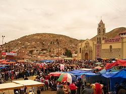 | ||
Weather 6°C, Wind N at 10 km/h, 89% Humidity University Universidad Técnica de Oruro Clubs and Teams Club San José, Club Atlético Nacional CAN Points of interest Nevado Sajama, Plaza Principal 10 de Fe, Zoológico, Monumento a la Virgen del Socav, Casco del Minero | ||
Oruro is a department in Bolivia, with an area of 53,588 km². Its capital is the city of Oruro. According to the 2012 census, the Oruro department had a population of 494,178.
Contents
- Map of Oruro Department Bolivia
- Provinces of Oruro
- Government
- Languages
- Notable people
- Places of interest
- References
Map of Oruro Department, Bolivia
Provinces of Oruro
The department is divided into 16 provinces which are further subdivided into municipalities and cantons.
Note: Eduardo Abaroa Province (#5) is both north of and south of Sebastián Pagador Province (#6).
Government
The chief executive office of Bolivia departments (since May 2010) is the governor; until then, the office was called the prefect, and until 2006 the prefect was appointed by the President of Bolivia. The current governor, Santos Tito of the Movement for Socialism – Political Instrument for the Sovereignty of the Peoples, was elected on 4 April 2010.
The chief legislative body of the department is the Departmental Legislative Assembly, a body also first elected on 4 April 2010. It consists of 33 members: 16 elected by each of the department's provinces; 16 elected based on proportional representation; and minority indigenous representative selected by the Uru-Chipaya people.
Languages
The languages spoken in the department are mainly Spanish, Quechua and Aymara. The following table shows the number of those belonging to the recognized group of speakers.