
Surface elevation 434 m Length 30 km | Catchment area 2,124 km (820 sq mi) Max. length 30 km (19 mi) Area 113.6 km² | |
 | ||
Lake type freshwater fjord, recent regulation Primary inflows Similar | ||
Lake Lucerne (German: Vierwaldstättersee, literally "Lake of the Four Forested Settlements", French: lac des Quatre-Cantons, Italian: lago dei Quattro Cantoni) is a lake in central Switzerland and the fourth largest in the country.
Contents
Map of Lake Lucerne, Switzerland
The lake has a complicated shape, with several sharp bends and four arms. It starts in the south-north bound Reuss Valley between steep cliffs above the Urnersee from Flüelen towards Brunnen to the north before it makes a sharp bend to the west where it continues into the Gersauer Becken. Here is also the deepest point of the lake with 214 m (702 ft). Even more west of it is the Buochser Bucht, but the lake sharply turns north again through the narrow opening between the Unter Nas (lower nose) of the Bürgenstock to the west and the Ober Nas (upper nose) of the Rigi to the east to reach the Vitznauer Bucht. In front of Vitznau below the Rigi the lake turns sharply west again to reach the center of a four-arm cross, called the Chrütztrichter (Cross Funnel). Here converge the Vitznauer Bucht with the Küssnachtersee from the north, the Luzernersee from the west, and the Horwer Bucht and the Stanser Trichter to the south, which is to be found right below the northeast side of the Pilatus and the west side of the Bürgenstock. At the very narrow pass between the east dropper of the Pilatus (called Lopper) and Stansstad the lake reaches its southwestern arm at Alpnachstad on the steep southern foothills of the Pilatus, the Alpnachersee. The lake drains its water in Lucerne from the literally correctly translated western arm Lake of Lucerne (Luzernersee) into the Reuss.
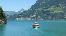
The entire lake has a total area of 114 km² (44 sq mi) at an elevation of 434 m (1,424 ft) a.s.l., and a maximum depth of 214 m (702 ft). Its volume is 11.8 km³. Much of the shoreline rises steeply into mountains up to 1,500 m above the lake, resulting in many picturesque views including those of the mountains Rigi and Pilatus.
The Reuss enters the lake at Flüelen (in the canton of Uri, the part called Urnersee) and exits at Lucerne. The lake also receives the Muota at Brunnen, the Engelberger Aa at Buochs, and the Sarner Aa at Alpnachstad.
It is possible to circumnavigate the lake by train and road, though the railway route circumvents the lake even on the north side of the Rigi via Arth-Goldau. Since 1980, the A2 motorway leads throuth the Seelisberg Tunnel in order to reach the Gotthard Route in just half an hour in Altdorf, Uri right south of the beginning of the lake in Flüelen.
Steamers and other passenger boats ply between the different villages and towns on the lake. It is a popular tourist destination, both for native Swiss and foreigners, and there are many hotels and resorts along the shores. In addition, the meadow of the Rütli, traditional site of the founding of the Swiss Confederation, is on the Urnersee shore. A 35 km commemorative walkway, the Swiss Path, was built around the Lake of Uri to celebrate the country's 700th anniversary in 1991.
NameEdit
The older name of the lake is Luzerner See ("Lake of Lucerne").
The (three) "Waldstätte(n)" (lit.: "Forested Sites/Settlements") since the 14th century were the confederate allies of Uri, Schwyz and Unterwalden. The notion of "Four Waldstätte(n)" (Vier Waldstätten), with the addition of the "town" of Lucerne, is first recorded in the 1450s, in an addition to the "Silver Book" of Egloff Etterlin of Lucerne. The name of Vierwaldstättersee is first used in the 16th century.
Each part of the lake has it own designation:
GeographyEdit
Lake Lucerne borders on the three original Swiss cantons of Uri, Schwyz, and Unterwalden (which today is divided into the cantons of Obwalden and Nidwalden), as well as the canton of Lucerne, thus the name Vierwaldstättersee (lit.: Lake of the Four Forested Settlements). Many of the oldest communities of Switzerland are along the shore, including Küssnacht, Weggis, Vitznau, Gersau, Brunnen, Altdorf, Buochs, and Treib.
Lake Lucerne is singularly irregular and appears to lie in four different valleys, all related to the conformation of the adjoining mountains. The central portion of the lake lies in two parallel valleys whose direction is from west to east, the one lying north, the other south of the ridge of the Bürgenstock. These are connected through a narrow strait, scarcely one kilometre wide, between the two rocky promontories called respectively Unter Nas and Ober Nas (Lower and Upper Nose). It is not unlikely that the southern of these two divisions of the lake—called Buochser Bucht—formerly extended to the west over the isthmus whereon stands the town of Stans, thus forming an island of the Bürgenstock. The west end of the main branch of the lake, whence a comparatively shallow bay extends to the town of Lucerne, is intersected obliquely by a deep trench whose south-west end is occupied by the branch called Alpnachersee, while the north-east branch forms the long arm of Küssnacht, Küssnachtersee. These both lie in the direct line of a valley that stretches with scarcely a break in between the Uri Alps and the Emmental Alps. At the eastern end of the Gersauer Becken, where the containing walls of the lake-valley are directed from east to west, it is joined at an acute angle by the arm of Uri, or the Urnersee, lying in the northern prolongation of the deep cleft that gives a passage to the Reuss, between the Uri Alps and the Glarus Alps.
The Urnersee occupies the northernmost and deep portion of the great cleft of the Reuss Valley, which has cut through the Alpine ranges from the St Gotthard Pass to the neighbourhood of Schwyz. From its eastern shore the mountains rise in almost bare walls of rock to a height of from 3,000 to 4,000 ft (910 to 1,220 m) above the water. The two highest summits are the Fronalpstock and the Rophaien (2078 m). Between them the steep glen or ravine of the Riemenstaldener Tal descends to Sisikon, the only village with Flüelen right on the shore on that side of the Urnersee. On the opposite or western shore, the mountains attain still greater dimensions. The Niederbauen Chulm is succeeded by the Oberbauenstock, and farther south, above the ridge of the Scharti, appear the snowy peaks of the Gitschen and the Uri Rotstock (2,928 m). In the centre opens the Reuss Valley, backed by the rugged summits of the Urner and Glarner Alps.
The breadth of these various sections of the lake is very variable, but is usually between one and two miles (3 km). The lake's surface, whose mean height above the sea is 434 metres, is the lowest point of the cantons of Uri, Obwalden and Nidwalden. Originally the lake was susceptible to variations in level and flooding along its shoreline. Between 1859 and 1860, the introduction of a needle dam in the Reuss in the city of Lucerne, just upstream from the Spreuerbrücke, allowed the lake level to be stabilised.
The culminating point of the lake's drainage basin, as well as Central Switzerland, is the Dammastock at 3,630 metres above sea level.
NavigationEdit
The lake is navigable, and has formed an important part of Switzerland's transport system for many centuries, and at least since the opening of the first track across the Gotthard Pass in 1230. This trade grew with the opening of a new mail coach road across the pass in 1830. This road had its northern terminus at Flüelen at the extreme eastern end of the lake, and the lake provided the only practical onward link to Lucerne, and hence the cities of northern Switzerland and beyond.
Whilst the development of Switzerland's road and rail networks has relieved the lake of much of its through traffic, it continues to be used by a considerable number of vessels, both private and public. Much of this usage is tourist or leisure oriented, but the lake continues to provide practical public and cargo transport links between the smaller lakeside communities.
Passenger boats of the Schifffahrtsgesellschaft des Vierwaldstättersees (SGV) provide services on the lake, including many run by historic paddle steamers. The SGV serves 32 places along the shore of the lake, with interchange to both main line and mountain railways at various points. Under separate management, the Autofähre Beckenried-Gersau provides a car ferry service between Beckenried, on the south bank of the lake, and Gersau on the north.
Cargo barges, to a local design known as Nauen, are still used on the lake. Some have been converted for use as party boats. Other barges are used by the gravel dredging industry that operates on the lake, using large dredgers to obtain sand and gravel for use in the construction industry.