Trisha Shetty (Editor)

Emmental Alps

Updated on
Edit
Like
Comment
Share on FacebookTweet on TwitterShare on LinkedInShare on Reddit
Peak
  
Brienzer Rothorn

Country
  
Switzerland

Parent range
  
Western Alps

Elevation
  
2,350 m (7,710 ft)

Highest point
  
Brienzer Rothorn

Emmental Alps httpsuploadwikimediaorgwikipediacommonsthu

Cantons
  
Bern, Lucerne, Obwalden and Nidwalden

Borders on
  
Bernese Alps, Uri Alps and Schwyz Alps

Topo map
  
Swiss Federal Office of Topography swisstopo

Mountains
  
Brienzer Rothorn, Pilatus, Hohgant, Augstmatthorn, Niederhorn

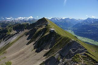
The Emmental Alps (German: Emmentaler Alpen) are a mountain range in the western part of the Alps, in Switzerland. They are located north-west of the Brünig Pass, mainly in the cantons of Lucerne, Bern, and Obwalden, with a small portion in the canton of Nidwalden. The highest summit of the range is the Brienzer Rothorn, which is also the highest point in the canton of Lucerne. The range is named after the Emme valley (German: Emmental). In the north-west corner one finds the relatively low, but widespread, and very furrowed Napf.

The Emmental Alps are separated from the Bernese Alps by the Aare valley to the south and connected to the Uri Alps by the four lakes Lungerersee, Sarnersee, Wichelsee, and Vierwaldstättersee to the east.

Notable peaksEdit

  • Brienzer Rothorn (2,350 m)
  • Tannhorn (2,221 m)
  • Arnihaaggen (2,207 m)
  • Höch Gumme (2,205 m)
  • Hohgant (2,197 m)
  • Augstmatthorn (2,137 m)
  • Pilatus (2,128 m)
  • Schrattenfluh (2,092 m)
  • Burgfeldstand (2,063 m)
  • Sigriswiler Rothorn (2,051 m)
  • Fürstein (2,040 m)
  • Wilerhorn (2,005 m)
  • Schafmatt (1,979 m)
  • Niederhorn (1,963 m)
  • Sieben Hengste (1,955 m)
  • Haglere (1,949 m)
  • Mittaggüpfi (1,917 m)
  • Schimbrig (1,815 m)
  • Honegg (1,546 m)
  • Wachthubel (1,415 m)
  • Napf (1,408 m)
  • References

    Emmental Alps Wikipedia