
Max. length 3.25 mi (5.23 km) Surface area 1,442 acres (584 ha) Area 5.836 km² Length 5.23 km Cities Webster | Max. width 1.125 mi (1.811 km) Shore length 17 mi (27 km) Surface elevation 145 m Width 1.811 km | |
 | ||
Islands Strip Island, Well Island, Cobble Island, Little Island, Long Island Similar Taumatawhakatangi | ||
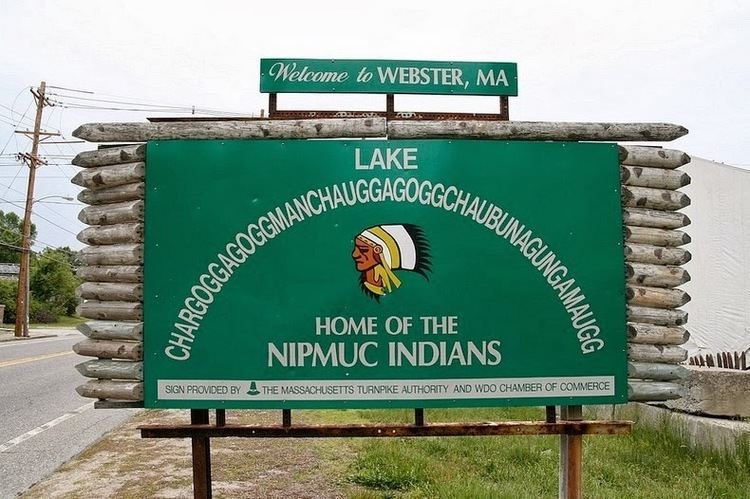
Lake Chaubunagungamaug, also known as Webster Lake, is a lake in the town of Webster, Massachusetts, United States. It is located near the Connecticut border and has a surface area of 1,442 acres (5.84 km2). Since 1921, the lake has also been known by a much longer name having 45 letters comprising fourteen syllables: Lake Chargoggagoggmanchauggagoggchaubunagungamaugg.
Contents
- Map of Lake Chaubunagungamaug Webster MA 01570 USA
- NameEdit
- Long name coined around 1921Edit
- GeographyEdit
- IslandsEdit
- MarinasEdit
- Pop cultureEdit
- References
Map of Lake Chaubunagungamaug, Webster, MA 01570, USA
NameEdit
The lake's name comes from Nipmuc, an Algonquian language, and is often said to mean, "Fishing Place at the Boundaries -- Neutral Meeting Grounds". A more fitting translation is "lake divided by islands", according to anthropologist Ives Goddard.
Today, "Webster Lake" may be the name most used, but some (including many residents of Webster), take pride in reeling off the longer versions. This lake has several alternative names. Lake Chaubunagungamaug is the name of the lake as recognized by the U.S. Department of the Interior, and is the name appearing in the earliest local records.
Algonquian-speaking peoples had several different names for the lake as recorded on old maps and historical records. However, all of these were similar in part and had almost the same translation. Among other early names were "Chabanaguncamogue" and "Chaubanagogum". Early town records show the name as "Chabunagungamaug Pond", which was also the name of the local Nipmuc town (recorded in 1668 and 1674 with somewhat different spellings). This has been translated as "boundary fishing place", but something close to "fishing place at the boundary" or "that which is a divided island lake" may be more accurate.
A map of 1795, showing the town of Dudley, and a 1795 map of Massachusetts indicated the name as "Chargoggagoggmanchoggagogg". A survey of the lake done in 1830 lists the name as "Chaubunagungamaugg", the older name. The following year, both Dudley and Oxford, which then adjoined the lake, filed maps listing the name as "Chargoggagoggmanchoggagogg". Anthropologist Ives Goddard considers that 1831 name to be a cartographer's creation that corrupted the actual name while confusing this lake with nearby Manchaug Pond.
Long name coined around 1921Edit
The exaggerated name "Lake Chargoggagoggmanchauggagoggchaubunagungamaugg" (/ˌleɪk tʃɚˈɡɒɡəɡɒɡ ˌmænˈtʃɔːɡəɡɒɡ tʃəˌbʌnəˈɡʌŋɡəmɔːɡ/), is a 45-letter alternative name for this body of fresh water, often cited as the longest place name in the United States and one of the longest in the world. Many area residents, as well as the official website of the town of Webster, consider the longer version correct.
The humorous translation is: "You fish on your side, I'll fish on my side, and nobody fish in the middle". Both the exaggerated name and its humorous translation were apparently invented by Laurence J. Daly, editor of The Webster Times. According to Ives Goddard, Curator of Anthropology at the Smithsonian Institution, Daly created this "monstrosity" around 1921.
Spellings of the long name vary; in 2009, following six years of press reports, the local Chamber of Commerce agreed to have the spelling changed on its signs, but a 45-letter version of the name arrayed in a semicircle is still used. Webster schools use one long form of the name in various capacities.
GeographyEdit
Webster Lake is a 1,270-acre (5.1 km2) lake with a 17-mile (27 km) shoreline in southern Massachusetts, near the Connecticut border. It is the third largest fresh body of water in Massachusetts, after slightly larger Long Pond, and the much larger Quabbin Reservoir. The average depth is 13 feet (4.0 m) and the maximum depth is 45 feet (14 m).
Although the lake is natural in origin, its outlet has a dam that raises the water level by a couple feet. The dam initially provided water for a mill, and subsequently the water rights to the lake were owned by Cranston Print Works; currently, the dam is owned by Webster Lake Preservation LLC.
The lake is commonly divided into three smaller bodies of water: North Pond, Middle Pond, and South Pond. They are connected by narrow channels.
IslandsEdit
Webster Lake has about 7–8 islands. Some have houses and are habitable; a few are extremely small and uninhabitable. They include:
MarinasEdit
Webster lake has two marinas:
Pop cultureEdit
In the 1950s, a plan to shorten the official name of the lake inspired a poem of doggerel verse which concludes:
"Touch not a g!" No impious hand
Shall wrest one from that noble name
Fifteen in all their glory stand
And ever shall the same.
For never shall that number down,
Tho Gogg and Magogg shout and thunder;
Chargoggagoggmanchauggagoggchaubunagungamaugg's renown
Shall blaze, the beacon of the town,
Three songs about the lake's name have been written. The first was a regional song from the 1930s. The second was recorded by Ethel Merman and Ray Bolger and released in 1954 by Decca and incorporates the tale about the lake's name according to the name's inventor, Laurence J. Daly, editor of The Webster Times. The most recent was released in 2010 by Diane Taraz.
On the show, Gilmore Girls, (Season 6, Episode 6) Kirk offers the name "Chargogagogmanchogagogcharbunagunggamog" as a potential street name for the Dragonfly Inn. He says the Nipmuc Indian name is said to mean, "You fish on your side of the lake; I'll fish on my side and no one will fish in the middle." According to Kirk, it could also mean "buffalo." That episode aired on October 17, 2005.