
Country United States County Worcester Incorporated 1832 Zip code 01570 | Settled 1713 Elevation 460 ft (140 m) Population 16,767 (2010) | |
 | ||
Weather 14°C, Wind NW at 16 km/h, 22% Humidity | ||
Webster is a town in Worcester County, Massachusetts, United States. The population was 16,767 at the 2010 census.
Contents
Map of Webster, MA, USA
History
Webster was first settled in 1713 and was officially incorporated on March 6, 1832. The area forming the town had previously been divided among the town of Dudley, the town of Oxford and an unincorporated gore. The primary founder was the manufacturer Samuel Slater, who came to the area after his celebrated activities in Pawtucket, Rhode Island, and founded several textile mills, one of which was taken over by the Cranston Print Works in 1936. He named the town after his friend Daniel Webster. Slater spent his last years in Webster and died and is buried there in Mount Zion Cemetery.
Geography
According to the United States Census Bureau, the town has a total area of 14.5 square miles (38 km2), of which 12.5 square miles (32 km2) is land and 2.0 square miles (5.2 km2), or 14.10%, is water.
The town is bounded on the north by Oxford; on the east by Douglas; on the south by Thompson, Connecticut, and on the west by Dudley, with which it is most closely tied culturally and politically.
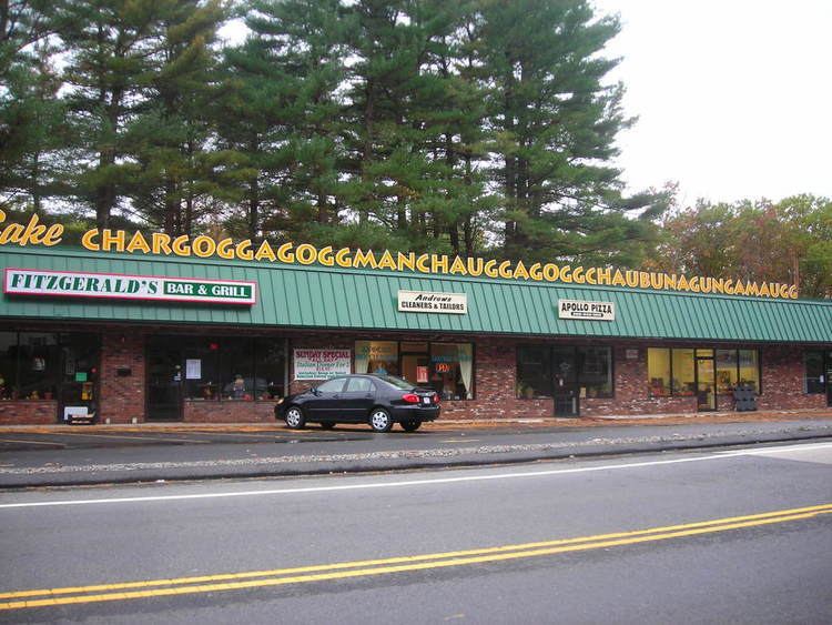
The town is home to Lake Chaubunagungamaug, also known as "Webster Lake", a body of water with a surface area of 1,442 acres (584 ha). Lake Chargoggagoggmanchauggagoggchaubunagungamaugg, a 45-letter alternative name for this body of water, is often cited as the longest place name in the United States and one of the longest in the world. Today, "Webster Lake" may be the name most used, but some residents of Webster take pride in reeling off the longer versions.
Demographics
As of the census of 2000, there were 16,415 people, 6,905 households, and 4,274 families residing in the town. The population density was 1,314.2 people per square mile (507.4/km²). There were 7,554 housing units at an average density of 604.8 per square mile (233.5/km2). The racial makeup of the town was 94.82% White (92.9% if non-Hispanic whites are counted), 1.11% Black or African American, 0.34% Native American, 0.95% Asian, 1.49% from other races, and 1.29% from two or more races. Hispanic or Latino of any race were 3.95% of the population. About 60% of the Latinos were Puerto Ricans.
The town is known for incorporating many Polish-American immigrants. Persons of Polish descent may constitute as much a third of the town's population. St. Joseph Basilica, the oldest Polish-American Catholic parish church in New England, is located in Webster.
As of 2000, there were 6,905 households out of which 28.2% had children under the age of 18 living with them, 45.4% were married couples living together, 11.8% had a female householder with no husband present, and 38.1% were non-families. 31.7% of all households were made up of individuals and 13.5% had someone living alone who was 65 years of age or older. The average household size was 2.34 and the average family size was 2.94.
In the town, the population was spread out with 23.2% under the age of 18, 7.4% from 18 to 24, 30.6% from 25 to 44, 22.2% from 45 to 64, and 16.7% who were 65 years of age or older. The median age was 38 years. For every 100 females there were 92.8 males. For every 100 females age 18 and over, there were 88.9 males.
The median income for a household in the town was $38,169, and the median income for a family was $48,898. Males had a median income of $37,863 versus $26,912 for females. The per capita income for the town was $20,410. About 8.1% of families and 11.0% of the population were below the poverty line, including 12.7% of those under age 18 and 14.5% of those age 65 or over.
Chaubunagungamaug Reservation, a state-recognized Nipmuc Indian reservation, is located within the town. There are over 500 tribe members officially recognized by the Commonwealth of Massachusetts, but they are not recognized as a tribal government by the Bureau of Indian Affairs.
Education
Public schools in Webster include Park Avenue School (grades K-4), Webster Middle School (grades 5-8), and Bartlett High School (grades 9-12). Webster Middle School opened in 2005, replacing the former Anthony J. Sitkowski Middle School, a building attached to Town Hall which is now an apartment building for senior citizens.
Three of Webster's Catholic churches also support elementary schools: St. Anne's, St. Joseph's and St. Louis
Economy
Mapfre Insurance (formerly the Commerce Insurance Group) is based in Webster.
Goya Foods has its Massachusetts division in Webster.
Media
Library
The Webster public library began in 1889. In fiscal year 2008, the town of Webster spent 1.07% ($299,159) of its budget on its public library—some $17 per person.
The Chester C. Corbin library was demolished in the fall of 2016, with its contents temporarily moved to the Webster Town Hall while a new building is built.