
1910 2,834 km (1,094 sq mi) | Established 11th century 1910 201,800 | |
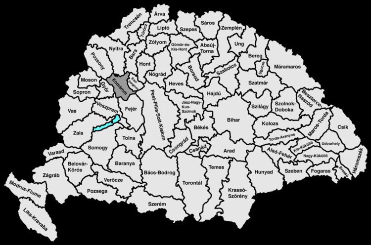 | ||
Komárom county (in Latin: comitatus Comaromiensis, in Hungarian: Komárom (vár)megye, in Slovak: Komárňanský komitát / Komárňanská stolica / Komárňanská župa, in German: Komorner Gespanschaft / Komitat Komorn) was an administrative county (comitatus) of the Kingdom of Hungary that lied in the present-day southern Slovakia (1/2) and north-western Hungary (1/2) on both sides of the Danube river.
Contents
Geography
Komárom County shared borders with the counties of Győr, Pozsony, Nyitra, Bars, Esztergom, Pest-Pilis-Solt-Kiskun, Fejér and Veszprém. The rivers Danube Vág and Nyitra ran through the county. It also covered the eastern part of the island between the Danube and the Little Danube (Slovak Žitný ostrov translates as English: Rye Island, Hungarian: Csallóköz). Around 1910 its area was 2,834 km2 (1,094 sq mi).
Capitals
The capital of the county was the Komárom Castle and later the town of Komárom (the town was divided into Komárom-Komárno).
History
The Komárom comitatus arose in the 11th century as one of the first comitatus' of the Kingdom of Hungary. It was situated within a radius of about 20 km around Komárom.
In 1920 the Treaty of Trianon assigned the part of Komárom county north of the Danube to Czechoslovakia (Komárno region). The southern part stayed in Hungary and merged with the southern part of Esztergom county to form Komárom-Esztergom county.
In 1938, the Czechoslovak part became part of Hungary by the First Vienna Award. Komárom county was recreated, which included, besides the territory of pre-1918 Komárom County, most of the Rye Island. After World War II, the pre-war situation was reestablished, except that the name of the Hungarian part became Komárom County again. This county was renamed to Komárom-Esztergom County in 1992. The part of the former county north of the river Danube is now in Slovakia, is part of the Nitra region and is largely identical with the Komárno district.
Demographics
In 1900, the county had a population of 180,024 people and was composed of the following linguistic communities:
Total:
According to the census of 1900, the county was composed of the following religious communities:
Total:
Subdivisions
In the early 20th century, the subdivisions of Komárom county were:
Komárno, Zemianska Olča, Dvory nad Žitavou and Hurbanovo are now in Slovakia.