
Country Hungary Area code(s) (+36) 33, 34 | Area rank 19th in Hungary Area 2,265 km² | |
 | ||
Postal code 2027 – 2028, 2067, 25xx, 28xx – 29xx Clubs and Teams Dorogi FC, FC Tatabánya, Esztergomi Vitézek Rugby SE, Tatabányai Vízmű SE, Tokodi Üveggyári SC Points of interest Tata Castle, Esztergom Basilica, Christian Museum, Lake Öreg, Fort Monostor Destinations | ||
Komárom-Esztergom (German: Komorn-Gran) (Slovak: Komárňansko-ostrihomská) is an administrative Hungarian county in Central Transdanubia Region, on the northern border with Slovakia. It shares borders with the Hungarian counties of Győr-Moson-Sopron, Veszprém, Fejér and Pest. Its county seat is Tatabánya.
Contents
- Map of KomC3A1rom Esztergom Hungary
- History
- Demographics
- Ethnicity
- Religion
- Politics
- Municipalities
- City with county rights
- Towns
- Villages
- References
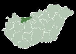
Map of Kom%C3%A1rom-Esztergom, Hungary
History
After World War I and the break-up of empires, the Hungarian Soviet Republic came to power in 1919, followed quickly by the Kingdom of Hungary. Komárom-Esztergom was created from the Hungarian parts of the pre-1918 counties Komárom and Esztergom, formerly part of the Austro-Hungarian Empire.
The pre-1918 situation was temporarily restored during World War II. Between 1950 and 1990, during the Communist regime, the county was called Komárom. Since the establishment of Hungary, it was named Komárom-Esztergom to refer to its historic past.
Demographics
In 2015, it had a population of 299,110 and the population density was 132/km².
Ethnicity
Hungarians constitute the majority of the population. The chief minorities are ethnic Germans (approx. 9,000), Roma (4,000) and Slovaks (3,000).
Total population (2011 census): 304,568
Ethnic groups (2011 census): Identified themselves: 270 933 persons:
Approx. 48,000 persons in Komárom-Esztergom County did not declare an ethnic group at the 2011 census.
Religion
Religious adherence in the county according to 2011 census:
Politics
The Komárom-Esztergom County Council, elected at the 2014 local government elections, is made up of 15 counselors, with the following party composition:
Municipalities
The county is ranked second in terms of population density among counties in Hungary: 66% of people live in towns.
City with county rights
Towns
(ordered by population, as of 2011 census)
Villages
municipalities are large villages.