
Surface area 6 km (2.3 sq mi) Area 6 km² Shore length 15 km | Primary inflows Basin countries Germany Max. depth 66 m (217 ft) Surface elevation 600 m Outflow location Loisach | |
 | ||
Similar Walchensee, Herzogstand, Jochberg, Heimgarten, Sylvenstein Dam | ||
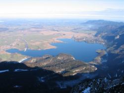
Kochelsee or Lake Kochel is located 70 kilometres (43 mi) south of Munich on the edge of the Bavarian Alps. The western third of the lake lies within the borders of the town of Schlehdorf, while the rest belongs to Kochel am See. The southern edge of the lake lies up against the mountains and the northern shore is bordered by bog lands. The history of the settlement of Kochel (previously Quochcalun) begins with Birg bei Altjoch, a rock extrusion on the shore of the lake. The name Kochel is derived from the Latin cocula meaning head or cone.
Contents
Map of Kochelsee, Germany
The Loisach flows into the lake at Schlehdorf and flows out at Kochel am See. A similar amount of water flows into the lake from the Isar through the Lake Walchen Power Plant.
OriginEdit
The lake was created during the last glacial period of the current ice age by the Loisach-Isar glacier. The bottom of the glacier scraped out the lakebed. The basin then filled with water at the end of the glacial period. The northern end of the lake silted up forming bogs.
SettlementsEdit
The following settlements border the lake:
All are part of the district Bad Tölz-Wolfratshausen.