
Country Serbia Settlements 23 Postal code 19320 Local time Thursday 2:56 AM | Time zone CET (UTC+1) Area 629 km² | |
 | ||
Weather 8°C, Wind NW at 6 km/h, 52% Humidity | ||
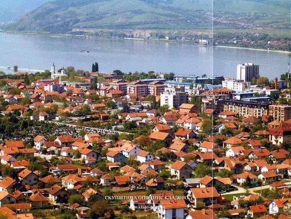
Kladovo (Serbian Cyrillic: Кладово, [klâdɔʋɔ]) is a town and municipality located in the Bor District of the eastern Serbia. It is situated on the right bank of the Danube river. The population of the town is 8,913, while the population of the municipality is 20,635 (2011 census).
Contents
- Map of Kladovo Serbia
- Name
- History
- Settlements
- Demographics
- Ethnic groups
- Economy
- Features
- Notable residents
- References
Map of Kladovo, Serbia
Name
In Serbian, the town is known as Kladovo (Кладово), in Romanian Cladova, in German as Kladowo or Kladovo and in Latin and Romanised Greek as Zanes. In the time of the Roman Empire, the name of the town was Zanes while the fortifications was known as Diana and Pontes (from Greek "sea" -pontos, or Roman "bridge" - pontem). Emperor Trajan had a number of fortications constructed in the area during the Roman times, such as the well-known Trajan's Bridge (Pontes was built on the Serbian side, Theodora was built on the Romanian side). Later, Slavs founded a settlement that was named Novi Grad (Нови Град), while Ottomans built a fortress here and called it Fethülislam. The present-day name of Kladovo is first recorded in 1596 in an Austrian military document.
There are several theories about the origin of the current name of the town: [1]
There is a settlement with the same name in Russia near Moscow and it is believed that this settlement was founded by Serbs who moved there from Serbian Kladovo in the 18th century. One of the suburbs of Berlin also has this name, which originates from the Slavic Lusatian Serbs (Sorbs) who live in eastern Germany.
The name is also found in the Arad and Timiș counties of Romania, Cladova, in Arad county Cladova, Arad, Cladova in Timiș county Cladova, Timiș
History
Early Bronze Age pottery of the Kostolac-Kocofeni culture was found in Donje Butorke, Kladovo, as well as several miniature duck-shaped vases of 14th century BC in Mala Vrbica and Korbovo. Bronze Age necropolis with rituals, pottery (decorated with meander) and other significant archaeological items were found in Korbovo.
In ancient times, a fortification near Trajan's bridge named Zanes/Pontes existed at this location, the area was governed by the Dacian Albocense tribe. In the Middle Ages, the Slavs founded here new town named Novi Grad (Нови Град), but it was razed by the Hungarians in 1502. It was rebuilt in 1524 by the Ottomans and received new name: Fethi Islam (Fethülislam). According to Ottoman traveler, Evliya Chelebi, who visited the town in 1666, most of its inhabitants spoke local Slavic language and Turkish language, while some also spoke Vlach. [2] In 1784, the population of Kladovo numbered 140 Muslim and 50 Christian houses. [3]
From 1929 to 1941, Kladovo was part of the Morava Banovina of the Kingdom of Yugoslavia.
Settlements
Aside from the town of Kladovo, the municipality includes the following settlements:
Demographics
According to the 2011 census results, the municipality has a population of 20,635 inhabitants.
Ethnic groups
The ethnic composition of the municipality:
Economy
The main business are the hydro-electric power plants of Đerdap: Iron Gate I and Iron Gate II. Other businesses began primarily to support the building and operation of the power plant, and the local folk.
The population of the villages around Kladovo is mostly supported by the family members who work as guest-workers in the countries of western Europe, agriculture is a side activity more than an income-generating one.
Features
Kladovo has one hospital, two daycare and kindergarten centers, one elementary school (grades 1 through 8), one high school and several vocational schools. Though the river Danube is very polluted by international standards, many people still fish in it. Before the power plant was built, sturgeon caviar from this area was very popular and was exported as a delicacy to the western Europe and the United States.
The nearby archeological sites include the remnants of Roman Emperor Trajan's bridge, one of many Trajan's tables, remnants of Trajan's road through the Danube's Iron Gates, and the Roman fortress Diana.
During the Ottoman occupation of the Balkan peninsula a fortress was built near the town. The fortress's name is Fetislam (originally Feht-ul-Islam meaning "gate of Islam") and in the 1970s it was converted into a sports complex containing children's playgrounds, track and soccer fields, handball, volleyball and tennis courts. The Iron Gates national park offers scenic views, excellent hunting grounds, and many trails for hiking (most trails are not well marked or maintained, so hiking is recommended only for the experienced).
The town has two hotels:"Đerdap" and "Aquastar Danube". Nearby the city (8 km on the road to Belgrade) there is a youth camp named "Karataš" (Turkish kara-tash for "black stone") which can host some of the visiting tourists. Kladovo has many cafés and restaurants, some offering live music entertainment late into the night. The town's quay stretches about 3 kilometers (1.9 mi) along the Danube river, offering quite beautiful scenery for strolling.
Notable residents
Born in Kladovo municipality:
Temporary residents: