
 | ||
The Kittanning Path was a major east-west Native American trail used crossing the Allegheny Mountains barrier ridge connecting the Susquehanna River valleys in the center of Pennsylvania to the highlands of the Appalachian Plateau and thence to the western lands beyond drained by the Ohio River. The Kittanning Village was the first major Delaware Indian settlement along the descent off the Allegheny Plateau.
Contents
Nature and the path
The nature of the path, in actual fact, a series of path alternatives funneling through seasonally or directionally more or less difficult notches—the gaps were one of only five animal power navigable places to cross east to west across the Appalachian Mountains west of New England. The Kittanny path (by other names) would also come to be used first by Dutch, then English and British colonial fur traders as well as Amerindian emigrants moving westwards before and after the French and Indian War and in the post-1780 settlers migrations west of the Mountain as the American Revolution entered its final years.
For Centuries the Kittanning Path like the similar Chief Nemacolin's Trail to the south provided an negotiable overland route through very tough country for the Iroquoian stock peoples, the Erie, the Susquehannock, the Iroquois, and Mingo and the Lenape, Miami, and Shawnee, and early Europe an settlers to cross the Allegheny Mountains barrier ridge. The path exploited one of the few so called gaps of the Allegheny rising alongside the feedwater streams draining into the Juniata River, a tributary of the wide ranging Susquehanna terminating on the Allegheny River due Northeast of Pittsburgh in what is now Armstrong County, Pennsylvania at the Native American village of Kittanning (at present day Kittanning, Pennsylvania).
The permanent Delaware settlement a few miles south of the Forks of the Ohio was believed to be the largest Native American village in the Ohio Country west of the Alleghenies by the time of the French and Indian War. It traversed a section of Pennsylvania closed to white settlement by the original settlement treaty with William Penn.
In an attempt to settle frontier borders, the English and Native Americans signed the Treaty of Fort Stanwix after the French and Indian War. It opened some of Pennsylvania west of the Alleghenies to white settlement. In the 1750s, this area had been the scene of a fierce raids by Native Americans against white settlement, and a major British retribution campaign during the French and Indian War.
A section of the original path is preserved in northwestern Cambria County.
Description (East to West)
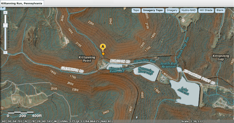
It began southeast of Altoona at Frankstown on the Juniata River. It ran west, crossing the Allegheny Ridge approximately 5 mi (8 km) west of Altoona at Kittanning Gap, later the location of the Horseshoe Curve railroad site.
The path ran northwest through Cambria County, passing east of Carrolltown. It entered Indiana County approximately 1 mi (1.6 km) south of Cherry Tree at "Canoe Place", the uppermost Native American canoe portage on the West Branch of the Susquehanna.
It followed a southwest course, through Yellow Creek State Park, then along the headwaters of Two Lick Creek, roughly past Uniontown, Pennsylvania (not the current Uniontown), Cookport, and Diamondville to U.S. Highway 422. It followed the approximate present course of the highway west and NNW through Indiana to Shelocta. It crossed into Armstrong County near Elderton and ended at the village of Kittanning on the east bank of the Allegheny.
History
The path was in use as early as 1721. In 1744 the trader John Hart was granted a license to trade with the Indians on western Pennsylvania lands that were closed at the time to white settlement. Hart established a way station campsite, called Hart's Sleeping Place, near the continental divide in Cambria County. The way station appeared on colonial maps and was used in 1752 by Gov. James Hamilton, and in 1754 by John Harris, the founder of Harrisburg. The last Native American encampment was recorded at the site in 1781.
In the 1750s the path became the route by which Lenape, unhappy with the treaty that had given away much of their land rights in western Pennsylvania, raided white settlements in central Pennsylvania. In 1755, the Lenape chief Shingas used the trail to attack British settlements in the Juniata River, returning with prisoners to the village of Kittanning. In early August 1756, the Lenape used the path to burn Fort Granville near present-day Lewistown and take prisoners. After the burning of the fort, the British dispatched Lt. Colonel John Armstrong, who pursued the Lenape along the path, camping at Canoe Place in early September before moving on to destroy the village of Kittanning. Armstrong earned the title "the Hero of Kittanning" for the raid, and later went on to serve as a Major General for the United States in the American Revolutionary War and to serve in the Second Continental Congress.
The Kittanning Path is not to be confused with the Kittanning Road, which was built in 1779 during the Sullivan Expedition. The Kittanning Road followed a more northerly course, running from Kittanning to the site of what is now Olean, New York.
The path was also traveled by Conrad Weiser, who was accompanied by William Franklin, the son of Benjamin Franklin. Weiser recorded the journey in his journal.
Preservation
The trail has been surveyed by historians through Cambria County. An authentic section of the original trail is preserved near Eckenrode Mill east of Carrolltown.