
- Tree Japanese Black Pine - Bird Seagull Population 65,434 (Sep 2015) | Area 334.4 km² Local time Monday 12:03 AM | |
 | ||
Weather 0°C, Wind NE at 3 km/h, 94% Humidity Points of interest Kessenuma Shark Museum, Tatsuganesan, Anbasan, Hayama Shrine | ||
Tsunami in kesennuma miyagi prefecture japan 2
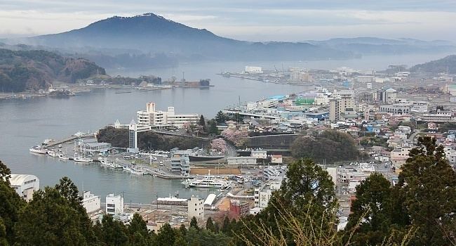
Kesennuma (気仙沼市, Kesennuma-shi) is a city in Miyagi Prefecture, in the Tohoku region of northern Japan. As of September 2015, the city had an estimated population of 65,434 and a population density of 197 inhabitants per square kilometre (510/sq mi). The total area is 332.44 square kilometres (128.36 sq mi). Large sections of the city were destroyed by the 2011 Tōhoku earthquake and tsunami and major fires on March 11, 2011.
Contents
- Tsunami in kesennuma miyagi prefecture japan 2
- Map of Kesennuma Miyagi Prefecture Japan
- Tsunami in kesennuma miyagi prefecture japan 4
- Geography
- Neighboring municipalities
- Climate
- History
- Economy
- Education
- Railway
- National highways
- International sisterfriendship cities
- Japanese sister cities
- Noted people from Kesennuma
- References
Map of Kesennuma, Miyagi Prefecture, Japan
Tsunami in kesennuma miyagi prefecture japan 4
Geography
Kesennuma is in the far northeastern corner of Miyagi Prefecture. The city wraps around the western part of Kesennuma Bay and also includes the island of Ōshima. Its coastline forms the southern boundary of the Sanriku Fukkō National Park, which stretches north to Aomori Prefecture.
The city borders Hirota Bay, Kesennuma Bay, and the Pacific Ocean to the east and Minamisanriku, Miyagi to the south. Iwate Prefecture makes up the remainder of its borders, with the city Ichinoseki to the west, and the city of Rikuzen-Takata to the north. The highest point in Kesennuma is 711.9 metres (2,336 ft) high, on the border with Motoyoshi, while the lowest point is at sea level. The Ōkawa River flows through the city and into Kesennuma Bay.
Neighboring municipalities
Climate
Kesennuma is situated in a temperate climate zone and has a moderate climate. The city's average temperature is 10.8 °C (51.4 °F) and its average annual precipitation is 1,370.6 mm (53.96 in). Its record high is 36.0 °C (96.8 °F) on August 15, 1994, and its record low is −12.6 °C (9.3 °F) on February 17, 1980. The city's climate is fairly similar to Sendai, the largest city in Miyagi Prefecture. Since Kesennuma is north of Sendai, it is naturally slightly cooler. However, Kesennuma is known to be fairly warm for a city at its latitude, largely because of ocean currents.
History
The area of present-day Kesennuma was part of ancient Mutsu Province and has been settled since at least the Jomon period by the Emishi people. During the later portion of the Heian period, the area was ruled by the Northern Fujiwara. During the Sengoku period, the area was contested by various samurai clans before the area came under the control of the Date clan of Sendai Domain during the Edo period, under the Tokugawa shogunate. The town of Kesennuma was established on June 1, 1889 with the establishment of the municipalities system.
Kesennuma City was formed on June 1, 1953, when the town of Kesennuma annexed the neighboring town of Shishiori and village of Matsuiwa. On April 1, 1955, the city annexed the villages of Niitsuki, Hashikami and Oshima. On March 31, 2006, the town of Karakuwa and on September 1, 2009 the town of Motoyoshi (both from Motoyoshi District) were likewise incorporated into Kesennuma.
On March 11, 2011, large parts of the city were destroyed by the tsunami which followed the Tōhoku earthquake. The island of Oshima and its 3,000 residents, included in the city limits, was isolated by the tsunami which damaged the ferry connections. After the tsunami, spilled fuel from the town's fishing fleet caught fire and burned for four days. As of 22 April 2011, the city had confirmed 837 deaths with 1,196 missing.
In August 2013, residents decided to scrap a fishing boat - the Kyotoku Maru No 18 - which was swept inland by a giant wave during the 2011 tsunami. There had been plans to preserve the boat as a monument, as it had become a symbol of the tsunami.
In 2014 Kesennuma became Japan's first "slow town".
Economy
Kesennuma relies on tourism and commercial fishing, the latter being what the city is known for, especially its tuna, pacific saury and skipjack tuna production, keeping the fishing port very active. It also has a shark fin fishery. Prior to the 2011 disaster, the city was Japan's busiest port for processing bonito and swordfish. Presently, fishing and associated industries account for 85% of jobs in the town.
Education
Kesennuma has five high schools, eight junior high schools, and fourteen elementary schools.