
ISO 3166 code JP-04 Area 7,285 km² | Area rank 17th Districts 10 | |
 | ||
Weather 1°C, Wind N at 26 km/h, 81% Humidity Population 2.303 million (31 Mar 2012) Points of interest Aoba Castle, Miyagi Baseball Stadium, Ōsaki Hachimangū, Sendai City Museum, Sendai Umino‑Mori Aquarium Colleges and Universities Tohoku University, Tohoku Gakuin University, Miyagi University of Educati, Miyagi University, Miyagi Gakuin Women's | ||
Tsunami in ishinomaki miyagi prefecture japan
Miyagi Prefecture (宮城県, Miyagi-ken) is a prefecture of Japan in the Tōhoku region on Honshu island. The capital is Sendai.
Contents
- Tsunami in ishinomaki miyagi prefecture japan
- Map of Miyagi Prefecture Japan
- Tsunami in shiogama miyagi prefecture
- History
- 2011 Thoku earthquake and tsunami
- Geography
- Cities
- Towns and villages
- Economy
- University
- Rail
- Expressways and toll roads
- National highways
- Ports
- Airports
- Sports
- Visitor attractions
- Famous festivals and events
- References
Map of Miyagi Prefecture, Japan
Tsunami in shiogama miyagi prefecture
History
Miyagi Prefecture was formerly part of the province of Mutsu. Mutsu Province, on northern Honshu, was one of the last provinces to be formed as land was taken from the indigenous Emishi, and became the largest as it expanded northward. The ancient capital was at Taga-jō in modern Miyagi Prefecture.
In the third month of second year of the Wadō era (709), there was an uprising against governmental authority in Mutsu Province and in nearby Echigo Province. Troops were promptly dispatched to subdue the revolt.
In Wadō 5 (712), the land of Mutsu Province was administratively separated from Dewa Province. Empress Genmei's Daijō-kan continued to organize other cadastral changes in the provincial map of the Nara period, as in the following year when Mimasaka Province was divided from Bizen Province; Hyūga Province was sundered from Ōsumi Province; and Tanba Province was severed from Tango Province.
During the Sengoku period various clans ruled different parts of the province. The Uesugi clan had a castle town at Wakamatsu in the south, the Nanbu clan at Morioka in the north, and Date Masamune, a close ally of the Tokugawa, established Sendai, which is now the largest town of the Tōhoku region.
In the Meiji period, four new provinces were created from parts of Mutsu: Rikuchū, Rikuzen, Iwaki, and Iwashiro.
The area that is now Aomori Prefecture continued to be part of Mutsu until the abolition of the han system and the nationwide conversion to the prefectural structure of modern Japan.
Date Masamune built a castle at Sendai as his seat to rule Mutsu. In 1871, Sendai Prefecture was formed. It was renamed Miyagi prefecture the following year.
2011 Tōhoku earthquake and tsunami
On March 11, 2011, a 9.0 magnitude earthquake and a subsequent major tsunami hit Miyagi Prefecture, causing major damage to the area. The tsunami was estimated to be approximately 10 meters high in Miyagi Prefecture.
On April 7, 2011: 7.4-magnitude earthquake strikes off coast of Miyagi, Japan, Japan's meteorological agency says. Workers were then evacuated from the nearby troubled Fukushima-Daiichi nuclear facility once again, as a tsunami warning was issued for the coastline. Residents were told to flee for inner land at this time.
Officials from the U.S. Geological Survey later downgraded the magnitude to 7.1 from 7.4.
In 2013, Crown Prince Naruhito and Crown Princess Masako visited the prefecture to see the progress made since the tsunami.
Geography
Miyagi Prefecture is in the central part of Tōhoku, facing the Pacific Ocean, and contains Tōhoku's largest city, Sendai. There are high mountains on the west and along the northeast coast, but the central plain around Sendai is fairly large.
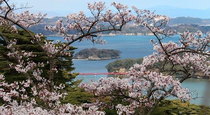
Matsushima is known as one of the three most scenic views of Japan, with a bay full of 260 small islands covered in pine groves.
Oshika Peninsula projects from the northern coastline of the prefecture.
As of 1 April 2012, 23% of the total land area of the prefecture was designated as Natural Parks, namely the Rikuchū Kaigan National Park; Kurikoma, Minami Sanriku Kinkasan, and Zaō Quasi-National Parks; and Abukuma Keikoku, Asahiyama, Funagata Renpō, Futakuchi Kyōkoku, Kenjōsan Mangokuura, Kesennuma, Matsushima, and Zaō Kōgen Prefectural Natural Parks.
Cities
Fourteen cities are located in Miyagi Prefecture:
Towns and villages
These are the towns and villages in each district:
Economy
Although Miyagi has a good deal of fishing and agriculture, producing a great deal of rice and livestock, it is dominated by the manufacturing industries around Sendai, particularly electronics, appliances, and food processing.
As of March 2011, the prefecture produced 4.7% of Japan's rice, 23% of oysters, and 15.9% of sauries.
In July 2011, the Japanese government decided to ban all shipments of beef cattle from northeast Miyagi Prefecture over fears of radioactive contamination. This has since been rescinded.
University
Rail
Expressways and toll roads
National highways
Ports
Airports
Sports
The sports teams listed below are based in Miyagi Prefecture.
Also, the Sendai Hi-Land Raceway hosts motorsport road races.
Visitor attractions
Sendai was the castle town of the daimyo Date Masamune. The remains of Sendai Castle stand on a hill above the city.
Miyagi Prefecture boasts one of Japan's three greatest sights. Matsushima, the pine-clad islands, dot the waters off the coast of the prefecture.
The following are also noted as attractions: