
Floor elevation 2,800 feet (850 m) Long-axis length 14 miles (23 km) | Long-axis direction East/West Width 16,093 m | |
 | ||
Area 110 square miles (280 km) Traversed by California State Route 155, California State Route 178 | ||
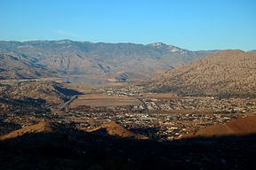
The Kern River Valley is a valley and region of the Southern Sierra Nevada, in Kern County, California.
Contents
F18 kern river valley
Geography
The Kern River Valley is bordered by subranges of the Sierra Nevada--- the Kern Plateau to the northeast, the Piute Mountains to the southeast, and Scodie Mountains to the south and the Greenhorn Mountains to the west.
The Kern River flows through the valley. A dam was completed in 1953, creating the recreational Lake Isabella reservoir, the valley's dominant geographic feature.
Highways to and through the valley include State Route 155 and State Route 178.
Settlements
Towns in the valley include:
References
Kern River Valley Wikipedia(Text) CC BY-SA