
County Kern Area codes 442/760 Elevation 813 m Zip code 93238 | Time zone PST (UTC-8) FIPS code 06-38310 Area 32.83 km² Population 1,395 (2010) | |
 | ||
Camping along the peaceful kern river near kernville california
Kernville is a census-designated place (CDP) in the southern Sierra Nevada, in Kern County, California, United States. Kernville is located 42 miles (68 km) northeast of Bakersfield, at an elevation of 2667 feet (813 m). The population was 1,395 at the 2010 census, down from 1,736 at the 2000 census.
Contents
- Camping along the peaceful kern river near kernville california
- Map of Kernville CA USA
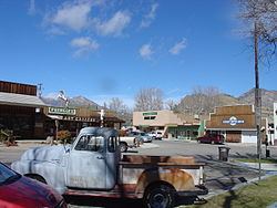
- Kernville california
- History
- Climate
- Points of interest
- 2010
- 2000
- Transportation
- References
Map of Kernville, CA, USA
Kernville california
History
The Kern River was named after artist and topographer Edward Kern, who accompanied John C. Fremont on his 1845 expedition. They camped at what was a fork of two rivers, now the middle of Lake Isabella. An 1858 gold rush led to the formation of a town briefly called Rogersville, then Williamsburg, which was soon renamed Whiskey Flat after a bar opened. In 1864, the town was renamed Kernville.
After decades of planning, the Isabella Dam project began in 1948. As a result, Kernville was moved upstream to its present location at the tip of the northeast fork of the man-made lake. The town has since continued to maintain its gold rush and old west roots to attract tourists and take advantage of nearby natural scenery and activities. The town's original location is slightly east of Wofford Heights. Foundations and such can still be seen when the lake is low. The famous Mountain Inn, built mainly to house movie stars and crew before the 1948 move, is now (partially) at the new Kernville, renamed the River View Lodge.
Whiskey Flat Days is the annual celebration of the historic wild west days of the area. Parade, wild west shootouts and historic camps, carnival, vendors and rodeo are just part of the festivities put on every President's Day weekend and attended by thousands of visitors.
The post office, established at the original site in 1868, was moved to the new site in 1951.
The original townsite is now registered as California Historical Landmark #132.
Climate
Climate type occurs primarily on the periphery of the true deserts in low-latitude semiarid steppe regions.
Points of interest
Kernville has a large tourist industry centered on the white water rapids of the Kern River. While white water rafting is the main attraction, one can also enjoy mountain biking, rock climbing, and other outdoor activities. Fly fishing is also popular; in particular, the golden trout is highly sought after for catch and release fishing. Downtown Kernville has an Old West look and contains a number of restaurants, antique shops and motels. The Kern Valley Museum houses a collection of historical items and displays. The nearby Kern Valley Airport is a popular general aviation destination for pilots, with on-site services including riverside camping and restaurant. The Needles granite formations about 25 miles toward the northern end of the valley are visible from some higher elevation locations.
2010
The 2010 United States Census reported that Kernville had a population of 1,395. The population density was 110.1 people per square mile (42.5/km²). The racial makeup of Kernville was 1,257 (90.1%) White, 1 (0.1%) African American, 19 (1.4%) Native American, 7 (0.5%) Asian, 0 (0.0%) Pacific Islander, 33 (2.4%) from other races, and 78 (5.6%) from two or more races. Hispanic or Latino of any race were 82 persons (5.9%).
The Census reported that 1,387 people (99.4% of the population) lived in households, 8 (0.6%) lived in non-institutionalized group quarters, and 0 (0%) were institutionalized.
There were 723 households, out of which 111 (15.4%) had children under the age of 18 living in them, 312 (43.2%) were opposite-sex married couples living together, 57 (7.9%) had a female householder with no husband present, 28 (3.9%) had a male householder with no wife present. There were 40 (5.5%) unmarried opposite-sex partnerships, and 5 (0.7%) same-sex married couples or partnerships. 282 households (39.0%) were made up of individuals and 132 (18.3%) had someone living alone who was 65 years of age or older. The average household size was 1.92. There were 397 families (54.9% of all households); the average family size was 2.50.
The population was spread out with 184 people (13.2%) under the age of 18, 74 people (5.3%) aged 18 to 24, 197 people (14.1%) aged 25 to 44, 521 people (37.3%) aged 45 to 64, and 419 people (30.0%) who were 65 years of age or older. The median age was 55.8 years. For every 100 females there were 97.3 males. For every 100 females age 18 and over, there were 98.9 males.
There were 1,072 housing units at an average density of 84.6 per square mile (32.7/km²), of which 532 (73.6%) were owner-occupied, and 191 (26.4%) were occupied by renters. The homeowner vacancy rate was 5.1%; the rental vacancy rate was 13.5%. 1,018 people (73.0% of the population) lived in owner-occupied housing units and 369 people (26.5%) lived in rental housing units.
2000
As of the census of 2000, there were 1,736 people, 800 households, and 482 families residing in the CDP. The population density was 137.5 people per square mile (53.1/km²). There were 1,210 housing units at an average density of 95.9 per square mile (37.0/km²). The racial makeup of the CDP was 90.55% White, 0.21% Black or African American, 2.07% Native American, 0.69% Asian, 0.06% Pacific Islander, 2.19% from other races, and 3.23% from two or more races. 8.18% of the population were Hispanic or Latino of any race.
There were 800 households out of which 15.4% had children under the age of 18 living with them, 50.6% were married couples living together, 7.4% had a female householder with no husband present, and 39.8% were non-families. 34.3% of all households were made up of individuals and 19.9% had someone living alone who was 65 years of age or older. The average household size was 1.99 and the average family size was 2.50.
In the CDP, the population was spread out with 20.2% under the age of 18, 3.6% from 18 to 24, 17.2% from 25 to 44, 28.4% from 45 to 64, and 30.6% who were 65 years of age or older. The median age was 52 years. For every 100 females there were 111.7 males. For every 100 females age 18 and over, there were 94.0 males.
The median income for a household in the CDP was $28,352, and the median income for a family was $33,409. Males had a median income of $43,875 versus $16,648 for females. The per capita income for the CDP was $23,159. About 15.4% of families and 17.3% of the population were below the poverty line, including 23.4% of those under age 18 and 8.9% of those age 65 or over.
Transportation
The city is served by the Kern Valley Airport, three miles south of town. The airport features a fly-in campground on site. An airfield cafe serves both pilots and visitors.
The city is also served by Regional Transit. The bus system runs from Kernville into Wofford Heights and then into Lake Isabella. Bus fares are $0.75 for children/seniors and $1.00 for adults. The bus runs every day except Sunday.