
Topo map USGS Walker Pass Country United States of America | Elevation 2,158 m | |
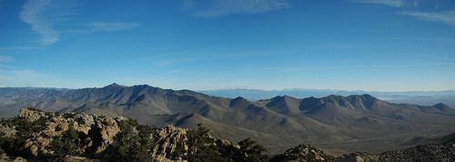 | ||
The Scodie Mountains are a sub-mountain range of the Southern Sierra Nevada rising from the Mojave Desert, and located in Kern County, California.
Contents
- Map of Scodie Mountains California 93255 USA
- GeographyEdit
- Kiavah WildernessEdit
- Natural historyEdit
- References
Map of Scodie Mountains, California 93255, USA
GeographyEdit
The range lies in an east-west direction directly west of the desert town of Ridgecrest, and southeast of the Kern River Valley and Lake Isabella. The mountain range reaches an elevation of 7,096 feet (2,163 m) above sea level at Cathie's Peak.
The range was named by the U.S. Forest Service for William Scodie, who established "Scodie's Store" (ca.1860) at the mouth of what is now named Scodie Canyon.
Kiavah WildernessEdit
The Scodie Mountains are home to the Kiavah Wilderness Area, managed by the Bureau of Land Management.
Natural historyEdit
The Scodie Mountains are an ecotone of Mojave Desert and Sierra Nevada flora, with plant communities differentiated by elevation.
They lie to the north of the Jawbone-Butterbredt Area of Critical Environmental Concern.