
County Kern FIPS code 06-39570 Elevation 766 m Zip code 93240 Area code Area codes 442 and 760 | Time zone PST (UTC-8) GNIS feature ID 1652739 Area 57.34 km² Population 3,466 (2010) | |
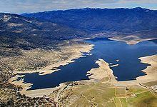 | ||
Lake Isabella (formerly, Isabella) is a census-designated place (CDP) in the southern Sierra Nevada, in Kern County, California, United States. It is named after the Lake Isabella reservoir and located at its southwestern edge, 6 miles (9.7 km) south of Wofford Heights in the Kern River Valley.
Contents
Map of Lake Isabella, CA, USA
The town of Lake Isabella is located 35 miles (56 km) east-northeast of Bakersfield, at an elevation of 2513 feet (766 m). The population was 3,466 at the 2010 census, up from 3,315 at the 2000 census.
Geography
Lake Isabella is located in Hot Springs Valley, part of the Kern River Valley, at 35°37′05″N 118°28′23″W.
According to the United States Census Bureau, the CDP has a total area of 22.1 square miles (57 km2), over 98% of it land.
Lake Isabella is at the confluence of the North and South Forks of the Kern River. These rivers are 'wild', in that they are not controlled by any dam upstream. Upstream on the North Fork white water enthusiasts play in the spring and early summer. The famous Golden Trout originate in these rivers in the high country to the north.
History
The area was inhabited for millennia by the indigenous Tübatulabal and Owens Valley Paiute. Gold was discovered nearby in 1853, leading to a gold rush and the founding of Keyesville. The 1863 Keyesville massacre occurred a few miles north.
The town of Isabella was founded by Steven Barton in 1893 and named in honor of Queen Isabella of Spain while her name was current during the 1893 Columbian Exposition. Lake Isabella was created in 1953 by a dam on the Kern River, forcing the town to move about 1.5 miles (2.4 km) south of the original site. The Isabella post office, which had opened in 1896, operated at the new site until the name was changed to Lake Isabella in 1957.
The dam's reservoir also inundated the original site of Kernville. Like Isabella, it was relocated, along with several of its historic buildings, to higher ground.
The area is a mecca for hikers, boaters, water skiers, fishermen, birders, hunters, wind surfers, kayakers, and other outdoor recreationists. Tourist trade is a major part of the area's economy.
2010
The 2010 United States Census reported that Lake Isabella had a population of 3,466. The population density was 156.6 people per square mile (60.4/km²). The racial makeup of Lake Isabella was 3,069 (88.5%) White, 6 (0.2%) African American, 96 (2.8%) Native American, 18 (0.5%) Asian, 7 (0.2%) Pacific Islander, 73 (2.1%) from other races, and 197 (5.7%) from two or more races. Hispanic or Latino of any race were 339 persons (9.8%).
The Census reported that 3,466 people (100% of the population) lived in households, 0 (0%) lived in non-institutionalized group quarters, and 0 (0%) were institutionalized.
There were 1,621 households, out of which 384 (23.7%) had children under the age of 18 living in them, 566 (34.9%) were opposite-sex married couples living together, 218 (13.4%) had a female householder with no husband present, 104 (6.4%) had a male householder with no wife present. There were 138 (8.5%) unmarried opposite-sex partnerships, and 14 (0.9%) same-sex married couples or partnerships. 592 households (36.5%) were made up of individuals and 299 (18.4%) had someone living alone who was 65 years of age or older. The average household size was 2.14. There were 888 families (54.8% of all households); the average family size was 2.76.
The population was spread out with 666 people (19.2%) under the age of 18, 299 people (8.6%) aged 18 to 24, 653 people (18.8%) aged 25 to 44, 1,106 people (31.9%) aged 45 to 64, and 742 people (21.4%) who were 65 years of age or older. The median age was 47.2 years. For every 100 females there were 95.2 males. For every 100 females age 18 and over, there were 91.9 males.
There were 2,164 housing units at an average density of 97.8 per square mile (37.7/km²), of which 1,019 (62.9%) were owner-occupied, and 602 (37.1%) were occupied by renters. The homeowner vacancy rate was 5.6%; the rental vacancy rate was 8.5%. 2,088 people (60.2% of the population) lived in owner-occupied housing units and 1,378 people (39.8%) lived in rental housing units.
2000
As of the census of 2000, there were 3,315 people, 1,526 households, and 877 families residing in the CDP. The population density was 150.0 people per square mile (57.9/km²). There were 2,168 housing units at an average density of 98.1 per square mile (37.9/km²). The racial makeup of the CDP was 90.44% White, 0.06% Black or African American, 1.90% Native American, 0.81% Asian, 0.06% Pacific Islander, 2.50% from other races, and 4.22% from two or more races. 6.76% of the population were Hispanic or Latino of any race.
There were 1,526 households out of which 21.9% had children under the age of 18 living with them, 41.9% were married couples living together, 10.3% had a female householder with no husband present, and 42.5% were non-families. 37.6% of all households were made up of individuals and 22.0% had someone living alone who was 65 years of age or older. The average household size was 2.17 and the average family size was 2.83.
In the CDP, the population was spread out with 23.0% under the age of 18, 6.0% from 18 to 24, 19.7% from 25 to 44, 23.5% from 45 to 64, and 27.8% who were 65 years of age or older. The median age was 46 years. For every 100 females there were 89.2 males. For every 100 females age 18 and over, there were 84.4 males.
The median income for a household in the CDP was $19,813, and the median income for a family was $24,800. Males had a median income of $24,896 versus $18,523 for females. The per capita income for the CDP was $11,452. About 18.2% of families and 20.5% of the population were below the poverty line, including 25.2% of those under age 18 and 13.8% of those age 65 or over.