
Elevation 5,764 m | ||
 | ||
Location On the border between China and the Siachen Glacier region (controlled by India, claimed by Pakistan. Range Eastern Karakoram Range | ||
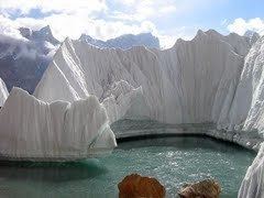
The Indira Col (altitude 5,764 metres (18,911 ft)) is a col (mountain pass, also called La in the local language) on the Indira Ridge in the Siachen Muztagh in the Karakoram Range. It is within 3 km of Sia Kangri to the west, the summit of which is the tripoint where territories controlled by India, Pakistan and China meet.
Map of Indira Col West
The col is a saddle between the Siachen Glacier to the south and the Urdok Glacier to the north, on the watershed between the Indus River basin and the Tarim Basin. It is too steep to easily descend north from the col to the Urdok Glacier.
The term Indira Col has also been applied to another, higher col 2.4 km further east on the Indira Ridge at (altitude 5,988 metres (19,646 ft)), from which it is possible to descend to the north. This eastern col was named Indira Col in 1912 by Bullock Workman, after one of the names of the goddess Lakshmi.
Colonel Narendra "Bull" Kumar reached Indira Col (the western col) in 1981. In 1998 Harish Kapadia reached the same col; on his map and text he refers to it as the "main Indira Col" and "Indira Col West", whereas he refers to the col 2.4 km to the east as "Indira Col East (Workman)."
The Indira Col is 2 km east of the point (about a km southeast of the peak of Sia Kangri) where the Actual Ground Position Line between Indian and Pakistani forces meets the border with China. Territories on all sides are disputed. The land immediately to the south of the col is claimed by both Pakistan and India and is controlled by India.