
 | ||
Restaurants FARMHO tavern, Thai Lime, Love Chix, Mattachioni, Nonna's Place | ||
Junction Triangle is a neighbourhood in Toronto, Ontario, Canada. It is located in the city's west end, just west of Lansdowne Avenue. The area is a triangle surrounded on all three sides by railway lines. The CNR/CPR mainline to the west, Metrolinx GO Transit Barrie line to the east, and the CPR east-west railway lines to the north. Bloor Street cuts across the middle of the neighbourhood, Dupont Street runs close to the northern edge, and Dundas Street close to the southern boundary. By some accounts, the recent residential developments of Davenport Village and Foundry Lofts, built on former factory lands north of CP Rail line, west of Lansdowne, south of Davenport and east of GO Transit Bradford/Newmarket/Barrie line, also belong in this neighbourhood.
Contents
Map of Junction Triangle, Toronto, ON, Canada
Name
For a long time there was no agreed upon name for the area, generically referred to as West Toronto, others considered parts Bloordale, north of Dupont west of present-day Campbell had old factories considered within boundaries of The Junction and West Toronto Junction, yet other parts of area remained officially unnamed.
In 2009, an effort was launched by locals in the community to find a name. Junction Triangle had been used by the city for the area since the 1970s. For demographics purposes the area is part of the Dovercourt-Wallace-Emerson-Junction district. A local residents association was called the South Junction Triangle Residents Association. One issue is that it is based on the nearby and much better known neighbourhood The Junction, and leads to frequent confusion. The area was also never part of the historic town of West Toronto Junction, but was called Town of West Toronto, before annex.
The Fuzzy Boundaries project was created to try to find a new name. A vote was held in March 2010. Some 230 options were submitted originally, and after a narrowing process the vote was between ten options. The final vote was:
Character
Historically the area was a centre for industry. The thin wedge of the triangle south of Bloor Street was almost entirely industrial lands and industrial areas also lined the railway tracks that surround the neighbourhood. Factories made paint, ceramics, and chemicals in the area. The Ontario Stock Yards were also nearby. The area became home to the workers in the factories, by the 1950s this was a multicultural group of mainly Italian, Polish, and Macedonian immigrants. Later, the area became predominantly Portuguese with mass immigration from the Azores and the exodus of better-off Italian families to the northern suburbs of Woodbridge and Vaughan.
Beginning in the 1970s, local residents became concerned by pollution in the area. The proximity of homes and schools to heavy industry led to a long battle between residents and factory owners. The fumes from the plants were clearly detectable, and studies found elevated levels of a number of organic chemicals in the areas air. In July 1988 an explosion at a glue factory showered the neighbourhood with a yellow chemical rain. Residents blamed a series of ailments on the pollution, though studies found that cancer rates were normal.
In response the city and other levels of government began fining firms that violated environmental regulations, and zoning restrictions were put in place to prevent factories from expanding. Beginning in the 1990s these policies, combined with the general deindustrialization of North America, saw many of the factories in the area close, especially the most polluting ones. Former plants have been converted to lofts, and others have been demolished leaving large brownfields. Some major factories do remain, notably the Nestle factory on Sterling that some days gives a strong chocolate smell to the area. The character of the neighbourhood has also started to change, as increasingly young downtown professionals taking full advantage of the areas multitude of public-transit and other social amenities (cycling paths) are replacing the retired factory workers of previous years, however, Portuguese community influence remains strong, and to a lesser extent Italian. The character of the area is gaining in popularity as more young families discover this neighbourhood tucked between more well known areas as Roncesvalles and Brockton. The area is attracting a lot of attention as a hidden gem with artists and other creative types, young professionals and first time buyers looking for a family-friendly area, close to the subway and other rapid-transit and within walking distance to other more established shopping areas.
It's been considered 'Junction Triange the next Liberty Village' but concluded its much more family friendly with a large portion of family homes to balance the future brownfield developments that are rapidly coming, the area residents are very actively involved with the planning processes to ensure the charm of area remains with the influx of development.
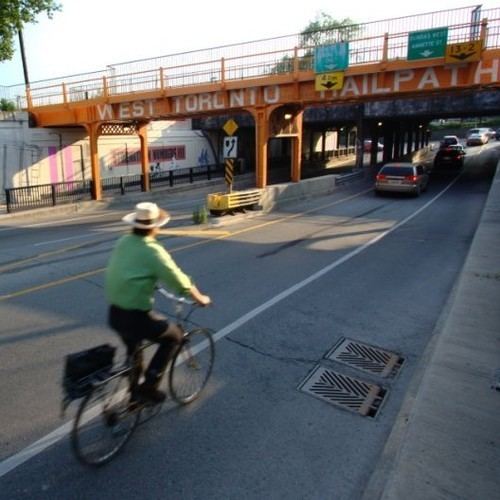
The West Toronto Railpath presently runs exclusively in the Junction Triangle and GO Transit is about to start the construction of a MobilityHub at Bloor St and the western border of neighourhood. TorontoLife magazine has named this extended area one BuyNow neighourhood due to its price affordability and proximity to downtown & transit.
Demographics
Census tract 0098.00 of the 2006 Canadian census overlaps exactly with the residential portion of Junction Triangle. According to that census, the neighbourhood has 6,666 residents. Average income is 28,067, a good deal below the Toronto average. The ten most common language spoken at home are:
Campbell Park
Ward 18 contains Campbell Park and Campbell Rink located just west of Lansdowne, north of Wallace at 255 Campbell Avenue. The Rink has a single pad, and is one of several outdoor compressor-cooled rinks in Toronto, with programming provided through Toronto's Parks and Recreation department. There is a clubhouse with a community kitchen, pay-what-you-can snack bar run by city staff, a skating lending program. In spring the park has community events including community campfires run by staff during the skating season, and in the summer local children can use the wading pool with qualified staff providing first aid.