
Source Pir Panjal Range Countries India, Pakistan | Length 725 km | |
 | ||
Cities Srinagar, Muzaffarabad, Mirpur, Azad Kashmir, Jhang, Sopore, Anantnag, Pampore, Awantipora, Baramulla Bridges Zero Bridge, Abdullah Bridge, Lal Mandi Footbridge Similar | ||
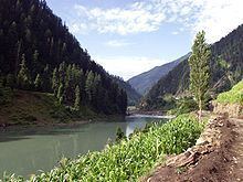
View of jhelum river srinagar
Jehlam River or Jhelum River (/ˈdʒeɪləm/) is a river that flows in the Indian and Pakistani controlled portions of Kashmir, and Punjab in Pakistan. It is the westernmost of the five rivers of Punjab, and passes through Jhelum District. It is a tributary of the Chenab River and has a total length of about 725 kilometres (450 mi).
Contents
- View of jhelum river srinagar
- Map of Jhelum River
- Verinag trout water spring is source of jhelum river tourism in kashmir
- Etymology
- History
- Course
- Dams and barrages
- Canals
- References
Map of Jhelum River
Verinag trout water spring is source of jhelum river tourism in kashmir
Etymology
Anjum Sultan Shahbaz recorded some stories of the name Jhelum in his book Tareekh-e-Jhelum as:
“ Many writers have different opinions about the name of Jhelum. One suggestion is that in ancient days Jhelumabad was known as Jalham. The word Jhelum is reportedly derived from the words Jal(pure water) and Ham (snow). The name thus refers to the waters of a river (flowing besides the city) which have their origins in the snow-capped Himalayas. However, some writers believe that when "Dara-e-Azam" reached a certain place on the river bank after winning many battles, he fixed his flag at that place and called it "Ja-e-Alam" which means "Place of the Flag". With the passage of time it became Jhelum from "Ja-e-Alam".
The Sanskrit name of this river is Vitasta. The river got this name from the mythological incident regarding the origin of the river as explained in Nilamata Purana. Goddess Parvati was requested by sage Kasyapa to come to Kashmir for purification of the land from evil practices and impurities of Pisachas living there. Goddess Parvati then assumed the form of a river in the Nether World. Then Lord Shiva made a stroke with his spear near the abode of Nila (Verinag Spring). By that stroke of the spear, Goddess Parvati came out of the Nether World. Shiva himself named her as Vitasta. He had excavated with the spear a ditch measuring one Vitasti(a particular measure of length defined either as a long span between the extended thumb and little finger, or as the distance between the wrist and the tip of the fingers, and said to be about 9 inches), through which the river - gone to the Nether World - had come out, so she was given the name Vitasta by him.
History
The river Jhelum is called Vitastā in the Rigveda and Hydaspes by the ancient Greeks. The Vitasta (Sanskrit: वितस्ता, fem., also, Vetastā) is mentioned as one of the major rivers by the holy scriptures — the Rigveda. It has been speculated that the Vitastā must have been one of the seven rivers (sapta-sindhu) mentioned so many times in the Rigveda. The name survives in the Kashmiri name for this river as Vyeth. According to the major religious work Srimad Bhagavatam, the Vitastā is one of the many transcendental rivers flowing through land of Bharata, or ancient India.
The river was regarded as a god by the ancient Greeks, as were most mountains and streams; the poet Nonnus in the Dionysiaca (section 26, line 350) makes the Hydaspes a titan-descended god, the son of the sea-god Thaumas and the cloud-goddess Elektra. He was the brother of Iris, the goddess of the rainbow, and half-brother to the Harpies, the snatching winds. Since the river is in a country foreign to the ancient Greeks, it is not clear whether they named the river after the god, or whether the god Hydaspes was named after the river. Alexander the Great and his army crossed the Jhelum in BC 326 at the Battle of the Hydaspes River where he defeated the Indian king, Porus. According to Arrian (Anabasis, 29), he built a city "on the spot whence he started to cross the river Hydaspes", which he named Bukephala (or Bucephala) to honour his famous horse Bukephalus or Bucephalus which was buried in Jalalpur Sharif. It is thought that ancient Bukephala was near the site of modern Jhelum City. According to a historian of Gujrat district, Mansoor Behzad Butt, Bukephalus was buried in Jalalpur Sharif, but the people of Mandi Bahauddin, a district close to Jehlum, believed that their tehsil Phalia was named after Bucephalus, Alexander's dead horse. They say that the name Phalia was the distortion of the word Bucephala. The waters of the Jhelum are allocated to Pakistan under the terms of the Indus Waters Treaty. India is working on a hydropower project on a tributary of Jhelum river to establish first-use rights on the river water over Pakistan as per the Indus waters Treaty.
Course
The river Jhelum rises from Verinag Spring situated at the foot of the Pir Panjal in the south-eastern part of the valley of Kashmir. It flows through Srinagar and the Wular lake before entering Pakistan through a deep narrow gorge. The Neelum River, the largest tributary of the Jhelum, joins it, at Domel Muzaffarabad, as does the next largest, the Kunhar River of the Kaghan valley. It also connects with rest of Pakistan and Pakistani Kashmir on Kohala Bridge east of Circle Bakote. It is then joined by the Poonch river, and flows into the Mangla Dam reservoir in the district of Mirpur. The Jhelum enters the Punjab in the Jhelum District. From there, it flows through the plains of Pakistan's Punjab, forming the boundary between the Chaj and Sindh Sagar Doabs. It ends in a confluence with the Chenab at Trimmu in District Jhang. The Chenab merges with the Sutlej to form the Panjnad River which joins the Indus River at Mithankot.
Dams and barrages
Water control structures are being built as a result of the Indus Basin Project, including the following: