Kalpana Kalpana (Editor)

Japan National Route 18

Updated on
Edit
Like
Comment
Share on FacebookTweet on TwitterShare on LinkedInShare on Reddit
Length
  
193.9 km

Japan National Route 18

Highway system
  
National highways of Japan

Major cities
  
Nagano, Ueda, Annaka, Myoko, Komoro

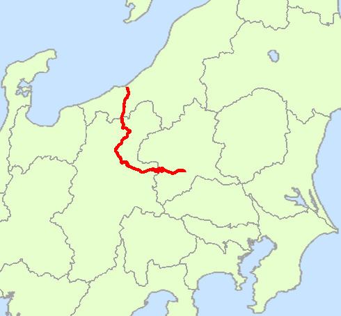
National Route 18 is a national highway connecting Takasaki, Gunma and Joetsu, Niigata in Japan.

Contents

Map of Japan, %E5%9B%BD%E9%81%9318%E5%8F%B7%E7%B7%9A

Route Data

  • Length: 193.9 km (120.5 mi)
  • Origin: Takasaki City (originates at junction with Route 17)
  • Terminus: Joetsu City (ends at Junction with Route 8)
  • Major cities: Komoro, Ueda, Chikuma, Nagano
  • History

  • 1952-12-04 - First Class National Highway 18 (from Takasaki to Joetsu)
  • 1965-04-01 - General National Highway 18 (from Takasaki to Joetsu)
  • Municipalities passed through

  • Gunma Prefecture
  • Takasaki - Annaka
  • Nagano Prefecture
  • Karuizawa - Miyota - Komoro - Tomi - Ueda - Sakaki - Chikuma - Nagano - Obuse - Nagano - Iizuna - Shinano
  • Niigata Prefecture
  • Myōkō - Jōetsu - Myōkō - Jōetsu
  • Intersects with

  • Gunma Prefecture
  • Routes 17, 354 and 406; at Takasaki City
  • Nagano Prefecture
  • Route 146; at Karuizawa Town
  • Route 141; at Komoro City - Ueda City
  • Routes 143, 144 and 152; at Ueda City
  • Route 403; at Chikuma City
  • Routes 19, 117 and 406; at Nagano City
  • Niigata Prefecture
  • Route 292; at Myoko City
  • Route 405; at Joetsu City
  • Routes 8 and 350; at the terminus in Joetsu City
  • Bypasses

    Among other sections already finished, a bypass running on the west side of the Chikuma River from the extreme southern part of Nagano City to Ueda is currently under construction. As of 2008, only a small amount of sections of this bypass has been completed. The completed sections are in Ueda, just west of the Chikuma River, and in Chikuma from Inariyama to just south of Yawata.

    References

    Japan National Route 18 Wikipedia