
Phone number 026-273-1111 Population 60,105 (Oct 2016) Local time Sunday 8:59 AM | Area 119.8 km² | |
 | ||
Website www.city.chikuma.nagano.jp Weather 1°C, Wind SE at 6 km/h, 62% Humidity Points of interest Kamiyamada Hot Spring, Chōraku‑ji Temple, Mt Kamuriki, Chikumashi Joyamashiseki Park, Zenkoji Daihonganbetsuin | ||
It s not sushi tachibana tsukemen chikuma nagano
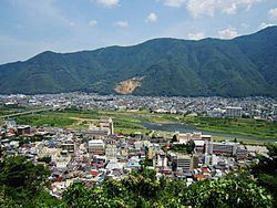
Chikuma (千曲市, Chikuma-shi) is a city located in central Nagano Prefecture, in the Chūbu region of Japan. As of 1 October 2016, the city had an estimated population of 60,105 and a population density of 502 persons per km². Its total area was 119.79 square kilometres (46.25 sq mi).
Contents
- It s not sushi tachibana tsukemen chikuma nagano
- Map of Chikuma Nagano Prefecture Japan
- Geography
- Surrounding municipalities
- History
- Education
- Railway
- Highway
- Local attractions
- Former city of Koshoku
- Former town of Kamiyamada
- Former town of Togura
- Notable people from Chikuma
- References
Map of Chikuma, Nagano Prefecture, Japan
Geography
Chikuma is located in the Chikuma River valley, south of Nagano city, at the junction of the Joshin-etsu Expressway and the Nagano Expressway.
Surrounding municipalities
History
The area of present-day Chikuma was part of ancient Shinano Province and has been settled since prehistoric times. The Mori Shogunzukakofun, a mountaintop keyhole tomb dating from near the end of the Kofun period is one of the latest of its type in eastern Japan. The area was part of the holdings of Matsushiro Domain during the Edo period, and also prospered from a series of post stations on the pilgrimage route to the famed Zenkō-ji temple. The modern city of Chikuma was founded on September 1, 2003 by the merger of the former city of Koshoku, the town of Kamiyamada (from Sarashina District), and the town of Togura (from Hanishina District).
Education
Chikuma has nine public elementary schools and four public middle schools. There is one public high school operated by the Nagano Prefectural Board of Education, and one combined middle/high school. There is also one special education school.
Railway
Highway
Local attractions
Former city of Koshoku
Koshoku (更埴) is the largest of the three municipalities that were joined to form the current Chikuma city. Spanning the Chikuma River and bordering Nagano city to the south, it entends from the apricot fields of Anzu no Sato in the east to the highland area Hijiri Kogen in the west. Koshoku's history dates back to the Kofun Period, and several major archaeological sites remain. Later, in the Meiji Period, the inns located in Inariyama became a popular stopover for pilgrims en route to Zenkō-ji.
Former town of Kamiyamada
Kamiyamada (上山田) lies on the western bank of the Chikuma River, just north of the town of Sakaki. A popular hot spring village dating back to the 19th century, the town was one of many places of lodging on the pilgrimage route to Zenkō-ji.
Former town of Togura
Togura (戸倉) lies on the east bank of the Chikuma River, across from Kamiyamada Onsen. With a history similar to that of Kamiyamada, it contains some hot spring bath facilities as well as the area's only railway station.