Neha Patil (Editor)

Japan National Route 13

Updated on
Edit
Like
Comment
Share on FacebookTweet on TwitterShare on LinkedInShare on Reddit
Length
  
306.1 km

Japan National Route 13

Highway system
  
National highways of Japan

Major cities
  
Yamagata, Yonezawa, Yuzawa, Shinjō, Yokote, Daisen

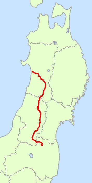
National Route 13 is a highway in Japan on the island of Honshū which runs from Fukushima City in Fukushima Prefecture to Akita City in Akita Prefecture.

Contents

Map of Japan, %E5%9B%BD%E9%81%9313%E5%8F%B7%E7%B7%9A

Route Data

  • Length: 306.1 kilometres (190.2 mi)
  • Origin: Fukushima City (originates at junction with Route 4)
  • Terminus: Akita City (ends at Junction with Route 7)
  • Major cities: Fukushima, Yonezawa, Yamagata, Akita
  • History

  • 1952-12-04: First Class National Highway 13 (from Fukushima, Fukushima to Akita, Akita)
  • 1965-04-01: General National Highway 13 (from Fukushima, Fukushima to Akita, Akita)
  • Municipalities passed through

  • Fukushima Prefecture
  • Fukushima
  • Yamagata Prefecture
  • Yonezawa - Takahata - Nan'yō - Kaminoyama - Yamagata - Tendō - Higashine - Murayama - Obanazawa - Ōishida - Funagata - Shinjō - Kaneyama - Mamurogawa
  • Akita Prefecture
  • Yuzawa - Yokote - Misato - Daisen - Akita
  • Intersecting routes

  • in Fukushima Prefecture
  • Routes 4, 115
  • in Yamagata Prefecture
  • Routes 47, 48, 112, 113, 121, 286, 287, 344, 347 and 458
  • in Akita Prefecture
  • Routes 7, 46, 105, 107, 108, 341, 342, 397 and 398
  • References

    Japan National Route 13 Wikipedia