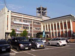
Country Japan - Flower Kobushi Magnolia Population 5,788 (Oct 2013) | - Tree Japanese pagoda tree Area 119 km² Local time Saturday 9:16 PM | |
 | ||
Weather 2°C, Wind W at 18 km/h, 87% Humidity Points of interest Oguni Gawa Riverside Ayu Park, Funagatamachi Rekishiminzoku Museum, Takakurayama | ||
Funagata (舟形町, Funagata-machi) is a town in Mogami District, Yamagata, Japan.
Contents
- Map of Funagata Mogami District Yamagata Prefecture Japan
- Geography
- Neighboring municipalities
- History
- Railways
- Highways
- References
Map of Funagata, Mogami District, Yamagata Prefecture, Japan
As of October 2013, the town has an estimated population of 5,788 and a population density of 48.6 persons per km². The total area is 119.03 square kilometres (46 sq mi).
Geography
Funagata is located in mountainous north-central eastern Yamagata Prefecture. The Mogami River runs through the town. The area is known for extremely heavy snowfall in winter.
Neighboring municipalities
History
The area of present-day Funagata was part of ancient Dewa Province and is mentioned in Nara period documents as a location of a fortified settlement on the road connecting Akita Castle on the Sea of Japan with Tagajo on the Pacific coast. During the Sengoku period, the area was under the control of the Mogami clan. During the Edo period, the Funagata was a river port on the Mogami River and a post station on the sankin kotai route to Edo and for pilgrims en route to the Three Mountains of Dewa. After the start of the Meiji period, the area became part of Mogami District, Yamagata Prefecture. The modern village of Funagata was established on April 1, 1889. It was elevated to town status on December 1, 1954.
