
Country Japan Area 161.8 km² Local time Sunday 3:01 AM | Phone number 0233-52-2111 Population 6,055 (Oct 2013) | |
 | ||
- Tree Japanese beech, Japanese cedar, Kousa Dogwood Points of interest Osegi, Mt. Atago, Ryubasan, Yakushiyama, Tsurigakemori | ||
Kaneyama (金山町, Kaneyama-machi) is a town in Mogami District, Yamagata Prefecture, Japan.
Contents
- Map of Kaneyama Mogami District Yamagata Prefecture Japan
- Geography
- Neighboring municipalities
- History
- Economy
- Railways
- Major roads
- Isabella Bird Memorial
- Notable people from Kaneyama
- References
Map of Kaneyama, Mogami District, Yamagata Prefecture, Japan
As of October 2013, the town has an estimated population of 6,055 and a population density of 37.4 persons per km². The total area was 161.79 square kilometres (62 sq mi).
Geography
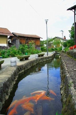
Kaneyama is located in northeastern Yamagata Prefecture, bordered to the north by Aomori Prefecture. The town is at an elevation of between 100 and 400 meters, surrounded by 1000 meter mountains. The area is known for its extremely heavy snowfalls in winter. There are many osegi waterways running through the town. Part of the town is within the borders of the Kurikoma Quasi-National Park
Neighboring municipalities
History
The area of present-day was Kaneyama part of ancient Dewa Province and during the Nara Period and early Heian period was an important fortified point on the road connecting Akita Castle on the Sea of Japan with Tagajo on the Pacific Ocean. During the Sengoku period, the area was under the control of the Mogami clan, who built Kaneyama Castle on what is now the center of the modern town. During the Edo period, the town was a post town on the Ushū Kaidō connecting Edo with what is now Aomori. The mountain passes north of the town center were a battlefield in the Boshin War of the Meiji restoration. After the start of the Meiji period, the area became part of Mogami District, Yamagata Prefecture. The modern village of Kaneyama was established on April 1, 1889 and was raised to town status on January 1, 1925.
Economy
The main industry is agriculture, livestock and forestry. Kaneyama is particularly famed for its cedar trees, and houses built in the traditional style (with cedar wood and white walls) can be seen around the town. The town is also noted for its production of ornamental (nishiki) koi.
These figures were taken from the 2000 census:
Primary sector (agriculture and forestry) - 15%Secondary sector (manufacturing and construction) - 49%Tertiary sector (services) - 36%Railways
Kaneyama has no train station of its own. The nearest Shinkansen station is in neighbouring Shinjō.
Major roads
Isabella Bird Memorial
British explorer Isabella Bird mentioned Kaneyama favourably in her account of her 1878 travels in Japan, Unbeaten Tracks in Japan:
"After leaving Shinjō this morning we crossed over a steep ridge into a singular basin of great beauty, with a semi-circle of pyramidal hills, rendered more striking by being covered to their summits with pyramidal cryptomeria, and apparently blocking all northward progress. At their feet lies Kanayama in a romantic situation, and, though I arrived as early as noon, I am staying for a day or two, for my room at the Transport Office is cheerful and pleasant, the agent is most polite, a very rough region lies before me, and Ito has secured a chicken for the first time since leaving Nikkō!"A monument commemorating Isabella Bird can be seen in the town centre.