
Location Jalaput Status Completed Type of dam Earthen Opened 1955 Surface area 97.12 km² | Opening date 2000 Impounds Machkund River Catchment area 1,963 km² | |
 | ||
Similar Duduma Waterfalls, PABR Dam, Dowleswaram Barrage, Tatipudi Reservoir, Somasila Dam | ||
The Jalaput Dam is a hydroelectric dam built on the Machkund River, a tributary of the Godavari River in India which rises in the Mudugal hills of Visakhapatnam District and nearby Ondra Gadda it becomes the boundary between Andhra Pradesh and Odisha. For over 48 km the river runs nearly north along a meandering course through the Padwa Valley. About 48 km south of Jeypore, it winds westward along the edge of the Plateau and then suddenly tums at a short angle to the south-west down a steep descent popularly known as Duduma Falls.
Contents
Map of Jalaput Dam, Khinimung, Odisha 764041
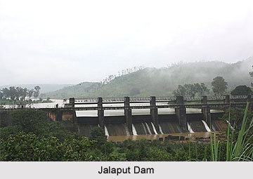
Jalaput Dam (and Reservoir) impounds 34.273 Tmcft of water for the needs of down stream 120 MW Machkund Hydro-Electric Scheme (MHES), which is in operation since 1955. The dam and the MHES are the joint projects of Andhra Pradesh and Odisha states. The existing six number power generation units have become old and obsolete compared to latest technology. It is much economical to install a new hydro-electric scheme with a 15 km long tunnel utilizing nearly 400 meters available level drop between Jalaput reservoir and the existing Balimela Reservoir back waters. There is also possibility to install huge capacity Pumped-storage hydroelectricity station for the needs of peaking power utilising high high water level drop. This reservoir will serve as upper pond and existing Balimela reservoir as tail pond for installing Pumped-storage hydroelectricity units. Thus this reservoir water can be put to use more productively. The existing MHES can also be kept in operation by diverting the surplus water from the nearby upper Kolab reservoir into the Machkund river basin by joining with nearly 4 km long tunnel. This would facilitate to utilise excess water from the upper Kolab reservoir for enhanced electricity generation in MHES and downstream Balimela power house by using nearly 200% more available head in Sileru river basin before putting finally for irrigation use.
Origin
Jalaput[1] derives its name from its local tribal dialect 'Jala' or 'Jal' means water. (In sanskrit too 'Jal' means 'Water') and 'Put' means a residence or a store house or large place. Jalaput water reservoir was the only water source for many of the local tribe in more than 100 tribal village in and around Jalaput in the koraput district. Before the present dam was built 55 years ago, it was a dense forest and a river surrounded by many tribal villages.
Jalaput[2] is a border village between Odisha and Andhra Pradesh. One bridge distinguishes between the two states. Both side of bridge are known as LF (Andhra Pradesh, Visakhapatnam district) and RF (Odisha, Koraput district). Earlier to formation of the jalaput dam it was known as Tentaput. The village is surrounded by many tribal villages still.
Jalaput [3], Machkund, and Onukadelli form the triangular shape of this hydro electricity generation project. The electricity generated here is supplied to many nearby towns including Visakhapatnam, Vijaywada in Andhra Pradesh and, Koraput and Jeypore in Odisha.
Communication
Jalaput is connected by road with all important towns in Odisha and Visakhapatnam in Andhra Pradesh. It is one of the most sought after visit places during winter. Araku Valley is 60 km from here. Visakhapatnam is the largest nearby city of this village.
Occupation
Agriculture is main occupation in nearby villages. The jalaputias (The residents of jalaput) are mainly Government employees. The retail business here is dominated by Telugu speaking people and few prominent Odia speaking businessmen. Wood cutting has become a prominent business here for a decade. That rise to many gang fights in last few years. District administration is worried about the rising fights amongst different groups for last five years. Apart from rice, jawa and many medicinal plants also form a significant part of agrarian business here. Presently many have entered into contractual farming for medicinal plants, jatropha plantation, and tissue culture.
The village has 5 decade old temples,Uma Maheshwara Temple in front of TMD. Basha's home, mosques behind Basha & Mustafa's home, and churches within a distance of 30 meters. Residents celebrate all festivals without any religious overtones. The village is right combination of Telugu and Odia language people. People here understand and communicate in both the languages with mixed accent.
Many aboriginal tribes inhabit nearby small villages. Most of the region was densely covered by forest. But recently due to massive deforestation in last one and half decade, much of the land has become barren.
The main village area resident are mostly Government Employees and few businessman .
Some of the trust worthy and Noted Government employees of this place, who earned respect of local people are late Shri O G K Murthy ,GuruRaju,Hussain, Late Narayana Swamy ,K.Venkata Rao.