
Existed: 1970 – present Length 296.1 km | Constructed 1970 | |
 | ||
East end: Country Fair Drive in Champaign, IL | ||
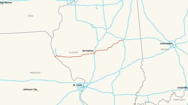
Interstate 72 (I-72) is an Interstate Highway in the midwestern United States. Its western terminus is in Hannibal, Missouri, at an intersection with U.S. Route 61; its eastern terminus is at Country Fair Drive in Champaign, Illinois. The route runs through the major cities of Decatur, Illinois and Springfield, Illinois. In 2006, the Illinois General Assembly dedicated all of Interstate 72 as Purple Heart Memorial Highway. The stretch between Springfield and Decatur is also called Penny Severns Memorial Expressway, and the section between Mile 35 and the Mississippi River is known as the Free Frank McWorter Historic Highway.
Contents
- Map of I 72 United States
- Route description
- History
- Chicago Kansas City expressway
- Four lane construction
- Auxiliary routes
- Related routes
- References
Map of I-72, United States
Route description
I-72 runs for just over 2 miles (3.2 km) in the state of Missouri. Its western terminus is an interchange with U.S. Route 61 to the Mark Twain Memorial Bridge over the Mississippi River. This bridge connects the city of Hannibal with Illinois. Presently, there are only two exits for I-72 in Missouri.
I-72 parallels the old Wabash Railroad from Hannibal, MO east through Illinois to Champaign, IL. The Norfolk Southern Railway operates this railroad route today.
In Illinois, I-72 runs for 182 miles (293 km). The portion of I-72 and I-172 from Springfield to Quincy is commonly referred to as the Central Illinois Expressway (CIE). As of 2007, I-72 has one business route -- Business Loop 72 in Jacksonville.
Near Valley City at mile marker 42 are the Valley City Eagle Bridges. These two individual two-lane spans bridge the Illinois River in rural west-central Illinois. Near mile marker 78, a sign marks 90 degrees longitude.
At its eastern terminus in Champaign, I-72 continues as Church Street (westbound) and University Avenue (eastbound), which stay as one-way streets for an additional 3 miles (4.8 km) into downtown Champaign.
History
Until the mid-1990s, I-72 ran from Springfield at Interstate 55 to Champaign at Interstate 57. On June 9, 1991, the American Association of State Highway and Transportation Officials (AASHTO) approved the establishment of Interstate 172 from the western terminus of I-72 at Springfield to Fall Creek, 4 miles (6.4 km) east of Hannibal, Missouri, though it was contingent on Federal Highway Administration (FHWA) approval. The FHWA preferred to designate the route I-72.
After discussions regarding extending an Interstate-standard highway through the state of Missouri, on April 22, 1995, AASTHO approved another renumbering. I-172 was renumbered in its entirety as I-72. The U.S. 36 extension west of Fall Creek was also given the I-72 designation. The Illinois Route 336 expressway was renumbered to I-172 from Fall Creek to Fowler.
Prior to September 2000, Mark Twain Avenue (old US 36) was composed of the current Mark Twain Avenue (now Route 79) and the portion of I-72 and US 36 west of Exit 157 to the Hannibal city limits. Route 79 terminated at the foot of the old Mark Twain Memorial Bridge at the corner of Third Street and Mark Twain Avenue. Signs along the four-lane expressway portion of Mark Twain Avenue marked the route as "Future I-72", while signs along what is now Route 79 had I-72 trailblazers to direct drivers to the temporary terminus at Fall Creek, Illinois.
When the new Mark Twain Memorial Bridge was completed in September 2000, I-72 was routed over the new bridge, along with US 36. Route 79 was extended along Mark Twain Avenue to terminate at Exit 157. The portion of I-72 and US 36 west of Exit 157 is now referred to as the V.F.W. Memorial Highway.
Originally, I-72 opened with a posted speed limit of 65 mph (105 km/h). However, when it first opened, some drivers were confused and were driving it at 35 mph (56 km/h), the old posted speed limit on Mark Twain Avenue. Later, Hannibal convinced MoDOT to lower the speed limit along I-72 and US 36 within the Hannibal city limits to 55 mph (89 km/h).
Chicago-Kansas City expressway
The concept of I-72 across Missouri was to create the Chicago – Kansas City Expressway, a rural four-lane highway across northern Missouri and west central Illinois from Cameron, Missouri at I-35 to Springfield, Illinois at I-55. This would provide a series of rural 4-lane highways (I-35, US 36, I-72, and I-55) connecting Chicago to the North American Free Trade Agreement (NAFTA) Corridor (High Priority Corridor 23). This would reduce the amount of through traffic, primarily truck traffic, in the St. Louis, Des Moines, and Quad Cities metropolitan areas by serving as an alternate route for I-70 and I-80. The Missouri portion of this route is designated as part of High Priority Corridor 61.
Based on the 157-mile (253 km) marker at Route 79, when US 36 is upgraded to Interstate standards across Missouri, the future western terminus of I-72 would be at Cameron, Missouri at the intersection with I-35. Currently, the west end of I-72 route is west of US 61 and flows concurrent with US 36 into Illinois. In 2004, US 36 was upgraded to a 4-lane expressway between US 61 and US 24 at the Rocket Junction (7 miles). There are three exits along this expressway: Veterans Road, Shinn Lane (Hannibal Regional Hospital), and US 24 East (Future Hannibal Bypass) at the Rocket Junction. This expressway is up to interstate standards (completed August 2007). Also, an interchange with Route 15 was installed in Shelbina. At Clarence, US 36 resumes 4-lane expressway status.
Due to funding priorities, upgrading US 36 between Macon and Hannibal was a low-priority project and was officially tabled by MoDOT. MoDOT committed to constructing the four-lane highway as a non-interstate expressway only if the five counties served by US 36 east of Macon would contribute half of the $100 million cost.
Four-lane construction
The first proposition of the expressway construction, Proposition 36, was passed by a majority of the voters in Macon, Marion, Monroe, and Shelby counties. However, residents of Ralls County rejected the proposition, citing lack of economic benefit for the county. US 36 cuts through the very northwest corner of Ralls County from Monroe City to the BNSF viaduct, a distance of 4 miles (6.4 km). Since the proposition failed in Ralls County, the entire proposition failed.
Businesses and voters in the other four counties still strongly supported the four-lane expressway project. At the next election, on August 3, 2005, voters of all five counties approved Proposition 36B, which excludes Ralls County from the Transportation Development District and allows for the construction of a 4-lane US 36 to be constructed without Ralls County's participation. The Proposition passed 66 percent to 34 percent and passed by a majority in all 5 counties.
In March 2008, the revised total cost of the project was estimated at $89 million. Additionally:
Road construction to complete the 52.4 miles (84.3 km) between Hannibal and Macon began in 2007. According to MoDOT, the estimated completion date of four lanes from Hannibal to Monroe City, 11.5 mi (18.5 km), was September 2008, from Monroe City to Shelbina, 18.4 mi (29.6 km), was December 2009, and from Shelbina to Macon, 22.5 mi (36.2 km), was December 2010.
In August 2010, the 4-lane expressway was completed from Macon to Hannibal, completing Missouri's portion of the Chicago-Kansas City Expressway.
Auxiliary routes
Related routes
Interstate 72 Business (abbreviated BL 72) is a Business Loop of I-72 in Jacksonville. It runs from the U.S. 36/I-72/U.S. 67 interchange southwest of Jacksonville north along the U.S. 67 bypass of Jacksonville to the former alignment of U.S. 36 (Morton Avenue). On Morton Avenue, BL 72 runs east through downtown Jacksonville until it reaches I-72 at exit 68. This is a distance of 9.5 miles (15.3 km).