
Length 72 km | Source elevation 225 m | |
 | ||
Basin size 115,000 km (44,000 sq mi) Discharge Average rate:67,000 cubic feet per second (1,900 m/s)Min: 9,959 cubic feet per second (282.0 m/s)Max: 318,468 cubic feet per second (9,018.0 m/s)Sediment Discharge:4.5 million tons/year12,300 tons sediment/day (average) | ||
{{about|the river in Alabama|the river in Newfoundland|Mobile River (Newfoundland)
Contents
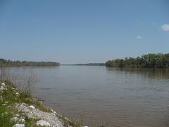
Map of Mobile River, Alabama, USA
The Mobile River is located in southern Alabama in the United States. Formed out of the confluence of the Tombigbee and Alabama rivers, the approximately 45-mile-long (72 km) river drains an area of 44,000 square miles (110,000 km2) of Alabama, with a watershed extending into Mississippi, Georgia, and Tennessee. Its drainage basin is the fourth-largest of primary stream drainage basins entirely in the United States. The river has historically provided the principal navigational access for Alabama. Since construction of the Tennessee-Tombigbee Waterway, it also provides an alternative route into the Ohio River watershed.
The Tombigbee and Alabama River join to form the Mobile River approximately 50 miles (80 km) northeast of Mobile, along the county line between Mobile and Baldwin counties. The combined stream flows south, in a winding course. Approximately 6 miles (10 km) downstream from the confluence, the channel of the river divides, with the Mobile flowing along the western channel. The Tensaw River, a bayou of the Mobile River, flows alongside to the east, separated from 2 to 5 miles (3 to 8 km) as they flow southward. The Mobile River flows through the Mobile-Tensaw River Delta and reaches Mobile Bay on the Gulf of Mexico just east of downtown Mobile.
Biodiversity
The Mobile River Basin historically supported the greatest biodiversity of freshwater snail species in the world (Bogan et al. 1995), including six genera and over 100 species that were endemic to the Mobile River Basin. During the past few decades, publications in the scientific literature have primarily dealt with the apparent decimation of this fauna following the construction of dams within the Mobile River Basin and the inundation of extensive shoal (a shallow place in a body of water) habitats by impounded waters (Goodrich 1944, Athearn 1970, Heard 1970, Stein 1976, Palmer 1986, Garner 1990).
Crossings
This is a list of bridges and other crossings of the Mobile River from Mobile Bay upstream to its source at the confluence of the Tombigbee and Alabama rivers. Proposals for a new bridge to carry Interstate 10 over the river have been debated for several years. Currently the Alabama Department of Transportation is conducting an environmental impact study for such a crossing and into the widening of the Jubilee Parkway, which carries Interstate 10 over Mobile Bay. The location of this bridge is of great debate with some parties pushing for a crossing south of the current tunnels while others are opposed to anything south of the Cochrane–Africatown USA Bridge.