
Length 67.24 km | ||
 | ||
Interstate 35W (I-35W) is an Interstate Highway in the U.S. state of Minnesota, passing through downtown Minneapolis. It is one of two through routes for Interstate 35 through the Twin Cities of Minneapolis and St. Paul, the other being Interstate 35E through downtown Saint Paul. I-35 splits into two branch routes: I-35W, which serves Minneapolis, and I-35E, which serves St. Paul.
Contents
- Map of I 35W Minnesota USA
- Route description
- Flooding
- Minnesota River crossing
- Mississippi River crossing
- I 35W and Highway 62 Crosstown Commons reconstruction project
- Future
- References
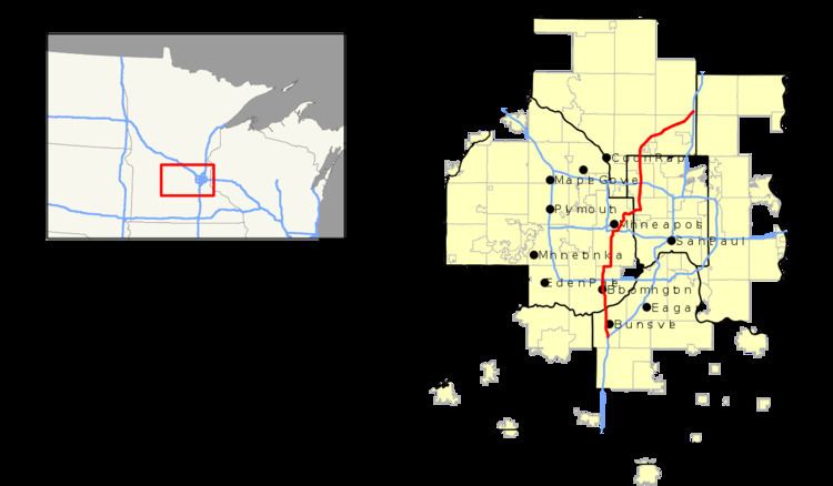
Map of I-35W, Minnesota, USA
Traveling north, I-35 splits at Burnsville, and the I-35W route runs north for 41 miles, carrying its own separate sequence of exit numbers. It runs through the city of Minneapolis before rejoining with I-35E to re-form I-35 in Columbus near Forest Lake. I-35W supplanted sections of old U.S. Highway 8 northeast of Minneapolis and old U.S. Highway 65 south of Minneapolis that have since been removed from the U.S. highway system.
During the early years of the Interstate Highway System, branching Interstates with directional suffixes such as N, S, E, and W were common nationwide. On every other interstate nationwide, these directional suffixes have been phased out by re-designating the suffixed route numbers with a loop or spur route number designation. In the case of I-35 in the Twin Cities area, since neither branch is clearly the main route and both branches return to a unified interstate beyond the cities of Minneapolis]] and St. Paul, AASHTO officials have allowed the suffixes of E and W in Minnesota to remain in the present day. A similar split on I-35 continues to exist in Texas at Dallas–Fort Worth Metroplex, for similar reasons as the I-35 split in the Minneapolis–Saint Paul area.
Route description
The southern terminus of I-35W is at Burnsville, where I-35 splits into I-35E and I-35W. While I-35E takes a northeasterly path into Saint Paul, I-35W heads north into Minneapolis. I-35W maintains a northbound direction in Burnsville with two lanes and adds a third lane at Burnsville Parkway. It then crosses the Minnesota River into Bloomington. At the Bloomington / Richfield city boundary, I-35W has a cloverleaf interchange with Interstate 494. I-35W continues northbound into Richfield, where it turns east and joins with Trunk Highway 62 for about 1/4 mile in what is locally known as the Crosstown Commons. I-35W and Highway 62 split as two lanes of I-35W turn northbound toward downtown Minneapolis, where it adds back a third lane and then later a fourth and a fifth lane at the 46th Street on-ramp.
I-35W swerves slightly northeast immediately south of downtown to avoid the Washburn-Fair Oaks Mansion District. Three lanes then split north onto Trunk Highway 65 (Old U.S. Highway 65), which exits into downtown. The two right-hand lanes of I-35W curve a sharp right east where it runs side by side with Interstate 94 for less than a mile, allowing drivers to exchange highways. Here, the interchange with Interstate 94 doesn't have direct access for southbound I-35W to eastbound I-94 or westbound I-94 to northbound I-35W. Drivers must use the Cedar and Washington Avenue exits to make these connections.
I-35W completes its eastern loop around downtown, and then crosses the Mississippi River on the St. Anthony Falls Bridge and winds northeast out of Northeast Minneapolis. Here, I-35W passes through industrial areas near the suburbs of St. Anthony, Lauderdale, Roseville, and Arden Hills.
Interstate 35W then meets Interstate 694 in New Brighton and Arden Hills at a cloverleaf interchange. U.S. Highway 10 joins I-35W one mile (1.6 km) north of the I-35W / I-694 interchange. I-35W and U.S. 10 run concurrently for another mile before the latter turns westward at Mounds View and Shoreview. I-35W passes next to the Twin Cities Ordnance Plant and again turns northeastward through the suburbs of Blaine and Lino Lakes. The communities of Lexington and Circle Pines are also nearby throughout this stretch. I-35W then merges with I-35E to re-form I-35 at Columbus near Forest Lake.
Interstate 35W carries its own set of exit numbers in the Twin Cities area, while Interstate 35E continues the Interstate 35 exit numbering scheme which goes between the Iowa state line and the city of Duluth.
Access between Interstate 35W and Interstate 35E in the Twin Cities area is done via circulator Interstate highways 494, 94, and 694; though many trunk and county highways, especially near the two downtown cores offer direct access between the two.
Legally, the route of Interstate 35W is defined as part of unmarked Legislative Route 394 in the Minnesota Statutes § 161.12(2), Interstate 35W is not marked with this legislative number along the actual highway.
Flooding
Interstate 35W is prone to heavy-rain event flooding in several areas, intersecting both natural habitats including the Minnesota Valley National Wildlife Refuge between Burnsville and Bloomington; and the dense urban areas through the city of Minneapolis (see Twin Cities climate). In the great 1965 Minnesota River flood, the highway was under water in the flood plain wetlands south of the Minnesota River bridge at Burnsville. Dikes have been constructed and the highway road has been raised since then. The storm sewer system under I-35W in the urban core of south Minneapolis has also been cited as a place prone to flash floods during rain events. Improvements continue to be made to this area as part of future projects.
Minnesota River crossing
When the Minnesota River bridge between Burnsville and Bloomington was completed in 1960 it was two-lanes in each direction. I-35W at the time only extended as far south as State Highway 13 in Burnsville. Improvements were made in 1984 to redeck and widen the bridge but subsoil problems found at the north end resulted in the new lanes being temporarily closed. In 1989, the lanes were opened as HOV when the Minnesota Department of Transportation expanded the north approach to carry the additional traffic.
Mississippi River crossing
On Wednesday, August 1, 2007, the Interstate 35W Mississippi River Bridge in Minneapolis, collapsed into the Mississippi River around 6:05pm CDT, killing 13 people and injuring 145. The metal arch bridge had a length of approximately 1,900 feet (580 m) and a roadway height of over 100 feet (30 m) above the river. The bridge connected Minneapolis southwest of the Mississippi River to the Northeast Minneapolis neighborhood and served residents in the northern suburbs of the metro area. Due to the collapse of the I-35W Bridge, I-35W traffic was temporarily detoured through eastbound Interstate 94 to northbound State Highway 280 where it meets up with I-35W in Roseville.
The replacement Interstate 35W Saint Anthony Falls Bridge was built in less than a year and opened to traffic on September 18, 2008 at 5:00am CDT, three months ahead of schedule.
I-35W and Highway 62 Crosstown Commons reconstruction project
The Crosstown Commons is one of the most congested traffic interchanges in Minnesota. While it is sometimes referred to as an intersection, it is a one-mile (1.6 km) merger or concurrency of Interstate 35W and State Highway 62. The layout is not a typical intersection: there is only a single level of roadbed and it creates a dogleg in Interstate 35W. This shared right-of-way "intersection" for Interstate 35W and State Highway 62 has been a topic of political debate for many years. There are only six lanes on the commons and all drivers merging from one highway to the other are required to change at least one lane as they merge and then diverge again. The name comes from the fact that Highway 62 is also known locally as the Crosstown Highway.
The project to improve the interchange began in May 2007, after bids were received in April 2007. The new interchange features three through-lanes for Interstate 35W in both directions, ending at 42nd Street, and two separate through-lanes for Highway 62 in each direction, eliminating the need to weave across traffic. The cost of correcting the deficiencies in that short stretch of highway was estimated to be $285 million.
In 2004, the City of Minneapolis threatened to withhold municipal consent for the project unless new bus lanes and bus stations were included. Lake Street currently has a bus station at grade with Interstate 35W on both sides. Eventually the project was altered to include the desired additional bus access. The bid was won by the Ames, Lunda, and Schafer consortium for the 2007 cost of $288 million. The project included 25 new bridges, 63 lane-miles of highway, and expanded the total roadway width from 6 lanes to 12 lanes at Lyndale Avenue. The bridges were cast in Coates, Minnesota and trucked in for on-site erection. The new design includes transit / HOV lanes and was completed in November 2010.
Future
The Interstate 35W Access Project proposed to add and reconfigure ramps roughly from Franklin Avenue to 45th Street in south Minneapolis. Some of the proposed changes included relocating the 35th / 36th Street ramps to 38th Street, adding new ramps at Lake Street, adding a northbound exit to 28th Street and reconstruct or widen roads to accommodate new ramps. Meanwhile, the proposed METRO Orange Line bus rapid transitway would run from the southern suburb of Lakeville to downtown Minneapolis on I-35W, passing through Burnsville, Bloomington, and Richfield. The Orange Line BRT station and the new off-ramps for Lake Street and 28th Street will begin construction in August 2017, as will an extension of the HOV/toll lanes southward to 46th Street.