
Other name(s) Romansh: En Discharge 730 m³/s | Length 517 km Basin area 25,700 km² | |
 | ||
Basin size 26,130 km (10,090 sq mi) Cities Innsbruck, Mühldorf, Wasserburg am Inn, Braunau am Inn, Rosenheim, Simbach am Inn, Waldkraiburg, Neuötting, Landeck Bridges Marienbrücke, Pontlatzbrücke | ||
The Inn (Latin: Aenus; Romansh: En) is a river in Switzerland, Austria and Germany. It is a right tributary of the Danube and is 517 kilometres (321 mi) long. The highest point of its drainage basin is the summit of Piz Bernina, at 4,049 metres (13,284 ft). The Engadine, the valley of the En, is the only Swiss valley from which its waters ends in the Black Sea (via the Danube).
Contents
- Map of Inn
- GeographyEdit
- TributariesEdit
- FlowEdit
- 2013 floodEdit
- Hydroelectric power plantsEdit
- References
Map of Inn
Average monthly flow (m³/s) of the Inn in Passau
Years 1921/2006
GeographyEdit
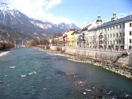
The source is located in the Swiss Alps, west of St. Moritz in the Engadine region, which is named after the river (Romansh Engiadina; Latin vallis Eniatina). Shortly after it leaves its source, the Inn flows through the largest lakes on its course, Lake Sils and Lake Silvaplana. It runs north-eastwards, entering Austria, and from Landeck eastwards through the Austrian state of Tyrol and its capital, Innsbruck (bridge over the Inn), and crosses the border into Bavaria near Kufstein.
On Bavarian territory the river runs northwards and passes Rosenheim, Wasserburg am Inn, and Waldkraiburg; then it turns east, runs through Mühldorf and Neuötting and is enlarged by two major tributaries, the Alz and the Salzach.
From here to the Danube, it forms the border between Germany (Bavaria) and Austria (Upper Austria). Towns on this last section of the river are Simbach on Inn, Braunau am Inn and Schärding. There are numerous small towns, including Braunau am Inn in Austria, and Marktl am Inn in Bavaria, Germany.
In Passau the Inn finally enters the Danube (as does the Ilz river there). Although the Inn has a greater average flow than the Danube when they converge in Passau, and its watershed contains the Piz Bernina also the highest point in the Danube watershed, the Inn is considered a tributary of the Danube, which has a greater length, drains a larger surface area, and has a more consistent flow. The Inn is the only river originating in Switzerland that ends in the Black Sea (via the Danube).
TributariesEdit
FlowEdit
Average monthly flow (m³/s) of the Inn in Passau
Years 1921/2006
2013 floodEdit
On June 3, 2013, the discharge of the Inn in Passau reached 6,820 m3/s (241,000 cu ft/s) and the water levels reached 12.85 m (42.2 ft), the highest recorded historic flood level since 1501. The historic centre of Passau, where the Danube, Inn and Ilz converge, was flooded severely.
Hydroelectric power plantsEdit
Currently, there are 23 hydroelectric power plants on the Inn. 17 of them are operated by Verbund AG. The power plants are listed beginning at the headwaters: