
Bridges Mangfall Bridge | Reference no. DE: 182 | |
 | ||
Main source Sources: tailstream of the Tegernsee726 m above sea level (NN) Similar Wendelstein, Tegernsee, Alps, Seehamer See, Taubenberg | ||
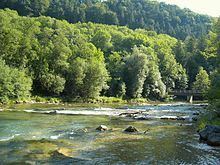
The Mangfall is a left tributary of the River Inn in Upper Bavaria. It is 58 km long. The Mangfall is the tailstream of the Tegernsee lake and discharges near Rosenheim into the Inn.
Map of Mangfall, Germany
References
Mangfall Wikipedia(Text) CC BY-SA