
Average depth 9.2 m (30 ft) Surface elevation 2,484 m | Frozen November - July (ice) Mean depth 9.2 m | |
 | ||
Similar Lunghin Pass, Piz Lunghin, Alps, Piz Grevasalvas, Septimer Pass | ||
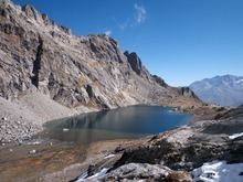
Lägh dal Lunghin (German: Lunghinsee) is a lake at an elevation of 2484 m, below the peak of Piz Lunghin, in the Graubünden, Switzerland. It is considered the source of the Inn River.
Map of L%C3%A4gh dal Lunghin, 7516 Bregaglia, Switzerland
References
Lägh dal Lunghin Wikipedia(Text) CC BY-SA