
- elevation 970 ft (296 m) - elevation 65 ft (20 m) Basin area 1,865 km² | Length 123 km Bridges Buskirk Bridge | |
 | ||
- left Green River, Little Hoosic River Sources The Berkshires, Hoosac Range Cities North Adams, Williamstown, Hoosick Falls, Adams, Troy, Hoosick, Schaghticoke, Cheshire, Pownal, Petersburgh, Pittstown | ||
The Hoosic River, also known as the Hoosac, the Hoosick (primarily in New York) and the Hoosuck (mostly archaic), is a 76.3-mile-long (122.8 km) tributary of the Hudson River in the northeastern United States. The different spellings are the result of varying transliterations of the river's original Algonquian name. It can be translated either as "the beyond place" (as in beyond, or east of, the Hudson) or as "the stony place" (perhaps because the river's stony bottom is usually exposed except in spring, or perhaps because local soils are so stony).
Contents
Map of Hoosic River, United States
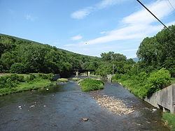
The Hoosic River Watershed is formed from tributaries originating in the Berkshire Hills of Massachusetts, the Green Mountains of Vermont, and the Taconic Mountains. The main (South) Branch of the river begins on the west slope of North Mountain and almost immediately fills the man-made Cheshire Reservoir in Berkshire County, Massachusetts. From there, the river flows north, west, and northwest, through the towns of Cheshire and Adams, the city of North Adams, and the town of Williamstown. It then travels through Pownal in the southwest corner of Vermont, after which it enters Rensselaer County, New York. There, it flows through the towns of Petersburgh and Hoosick, where it passes over a hydroelectric power dam in the village of Hoosick Falls. (There are also dams in Johnsonville, Valley Falls, and Schaghticoke.) The river provides the northwest border of the town of Pittstown, then flows through the town of Schaghticoke with its villages of Valley Falls and Schaghticoke before it terminates at its confluence with the Hudson 14 miles (23 km) above the city of Troy.