
 | ||
Early construction
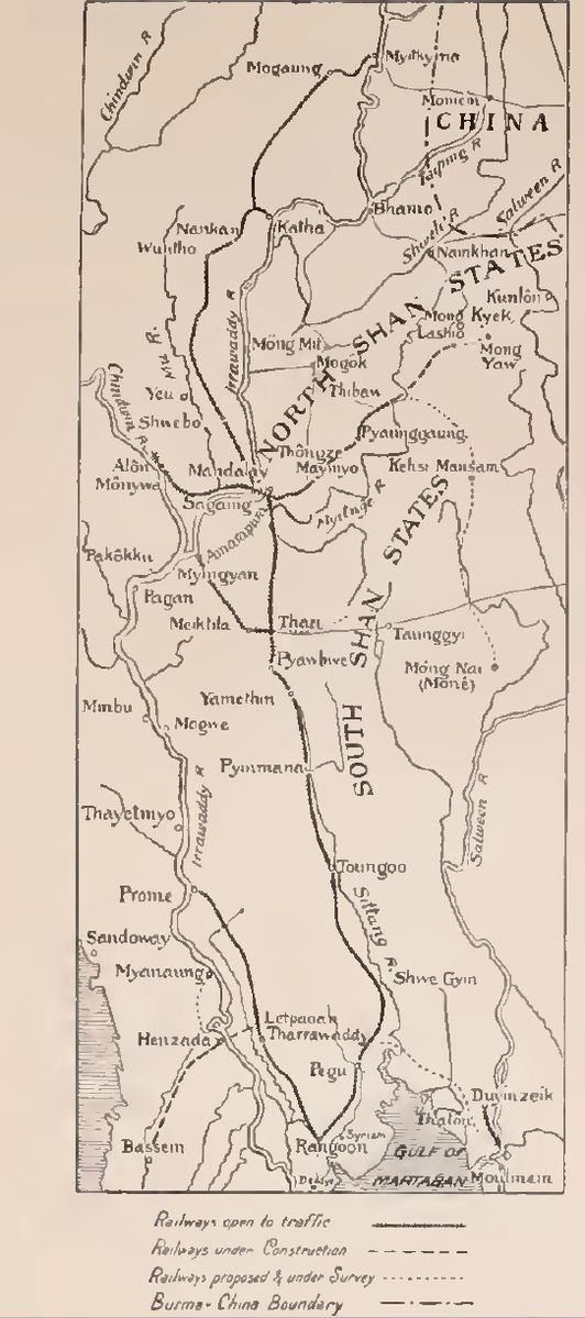
Rail transport was first introduced in Burma in May 1877, when Lower Burma was a colony of the United Kingdom and a part of British India, with the opening of the Rangoon to Prome line by The Irrawaddy Valley State Railway. This line, 163 miles long, tracing the course of the Irrawaddy river, was built over three years with labour imported from India, particularly from the areas affected by the Bihar famine of 1873–74. In 1884, a new company, The Sittang Valley State Railway, opened a 166-mile line along the Sittang River from Rangoon to the town of Toungoo via Pegu. While the Irrawaddy line was considered to be of commercial importance because it could be used to move rice from the valley to the main port at Rangoon, the Sittang line was of considerable strategic importance because of the proximity of Toungoo to the border with Upper Burma, then a part of the Ava kingdom. This became evident at the start of the Third Anglo-Burmese War a year after the opening of the railway and during the unrest that followed the war. The construction cost for the two lines was £1,926,666 and the railway was profitable by 1888 returning more than 5% on the capital expenditure.
Contents
- Early construction
- The Burma Railway Company
- Burma Mines Railway
- The Siam Burma Railway
- After independence
- Rail network extension activity
- Ongoing projects
- See also
- References
With the annexation of Upper Burma, the railway was extended by 220 miles from Toungoo to Mandalay, the fallen capital of the Ava kingdom with the extended railroad opening in 1889. Following the opening of this section, the Mu Valley State Railway was formed and construction began on a railway line from Sagaing to Myitkyina and connected Mandalay to Shwebo in 1891, to Wuntho in 1893, to Katha in 1895, and to Myitkyina in 1898. With the opening of this railway, a continuous 724 mile railway line ran from Rangoon to Myitkyina through the Kachin Hills except for a ferry crossing of the Irrawaddy at Sagaing. The Inwa Bridge at Sagaing, the only one across the Irrawaddy River in Burma, was opened in 1934, with two decks, one for road traffic and one for rail traffic. Destroyed by the British during their retreat from Burma in the Second World War it was rebuilt in 1954 after Burmese independence.
The Burma Railway Company
In 1896, before the completion of the line to Myitkyina, the three companies were combined into the Burma Railway Company as a state owned public undertaking. Between 1898 and 1905 another 278 miles of railway was constructed. A 110 branch line from the Rangoon-Pyay railroad connected Bassein in the Irrawaddy delta to Rangoon and the Mandalay - Hsipaw-Lashio railway traversed 117 miles through the Shan Hills almost all the way to the border with China. The latter railroad included the Gokteik viaduct, a 2260 feet long, 320 feet high viaduct across the Gokteik gorge near Nawnghkio. When built, it was the longest such viaduct in the world. The track rises a continuous 1:40 gradient throughout its length and the viaduct, designed by Alexander Rendel & Sons and constructed by the Pennsylvania Steel Company was considered an engineering marvel at that time. The Mandalay-Lashio railway was to extend to Kunlong on the border, and then on to the Yunnan province of China (see Yunnan–Burma Railway) but the plan was abandoned because of the difficult terrain.
In 1907, a line was opened connecting Pegu and Moulmein, the original capital of British Burma (before the Second Anglo-Burmese War). The line went up to Martaban on the Gulf of Martaban at the terminus of the Salween River and passengers had to take a ferry to cross over to Moulmein. (It was not until the Thanlwin Bridge opened in 2006 that it was possible to go from Rangoon to Moulmein by rail.) Sometime after the First World War, a line was constructed between Moulmein and Ye at the northern end of the Mergui Archipelago. Meanwhile, the last major rail line constructed in Burma was between 1914 and 1918 when a line was built from Thazi on the Rangoon-Mandalay line to Kalaw, a hill station in the hills of the Southern Shan State.
In 1928, the Burma Railway Company was dissolved and the railways were brought directly under the government and renamed Burma Railways and, around this time, the railways began to lose money because of competition from road transport. With the return on capital declining, Burma Railways became the single biggest debt item when the financial separation of India and Burma took place in 1937. The coal, the rolling stock, engines, were all imported either from India or from Britain.
Burma Mines Railway
In 1908, the Burma Mines Railway was completed, an 80 kilometres (50 mi) long 2 ft (610 mm) narrow gauge line from Namyao, on the Mandalay - Lashio branch of Myanmar Railways, via Namtu to Bawdwin.
The Siam-Burma Railway
The British had long planned to construct a railway line connecting India with Siam (now Thailand) and China and British companies had surveyed the possibility of building a railway from Rangoon to the Yunan province to link up with a second line from Bangkok to the Yunan province but were unable to find financial backing for the project. When the Japanese conquered Thailand and Burma, they decided to build a railway connecting their South East Asian territories with Burma, partly to facilitate the movement of troops and supplies for the planned invasion of India. Since the Yunan was in the hands of the Chinese under Chiang Kai-shek, they looked for a southern route to Burma from Thailand and settled on a line from Ban Pong to Thanbyuzayat across the mountains that separate the two countries. Since Thanbyuzayat was on the Moulmein - Ye railway line, and Ban Pong connected to Bangkok via Kanchanaburi, the line would provide a direct connection (with a ferry ride from Moulmein to Martaban) between Bangkok and Rangoon. The Japanese built the lines partly using allied POWs and it is estimated that 15,000 allied prisoners of war and 150,000 others lost their lives during the construction of the 245-mile (394 km) railroad (at about 675 deaths per mile). The construction is partly memorialised in the film The Bridge on the River Kwai.
After independence
In 1942, the country had 3313 route-km of meter gauge track, but during World War II the Japanese removed about 480 km. By the end of the conflict only 1085 route-km was operational, in four isolated sections. After Myanmar gained independence from the UK in 1948, the rail network was rebuilt. By 1961 the network extended 3020 km, and then remained constant until the opening of a 36 km line from Kyaukpadaung to Kyini in October 1970. This marked the start of a construction and track-doubling boom, and by 2000 MR operated 5068 track-km divided into 11 operating divisions. Most of the routes are single track although large parts of Yangon-Pyay and Yangon-Mandalay routes are double-track.
Rail network extension activity
1988:
1989:
1990:
1992:
1993: Three Lines Including
1994: Two Lines Including
1995: Three Lines Including
1996: Four Lines Including
1997: Two Lines including
1998:
2003:
2004: Two Line including
2005:
2006:
2007:
2008:
In December 2008, Myanmar Railways has total track of 5125 km, including double track section on Yangon - Mandalay.
Ongoing projects
Projects begun in 2009: