
 | ||
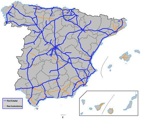
The Spanish motorway (expressways) network is the eleventh largest in the world by length,. As of 2013, there are 16,583 km (10,304 mi) of High Capacity Roads (Sp. Vías de Gran Capacidad) in the country. There are two main types of such roads, autopistas and autovías, which historically differed in the strictness of the standards they are held up to.
Contents
- Differences between autopista and autova
- State managed motorways
- Interurban motorways
- Beltways city accesses and urban highways
- Regional managed motorways
- Andalusia
- Aragon
- Asturias
- Balearic Islands
- Basque Country
- Canary Islands
- Castile La Mancha
- Castile and Len
- Cantabria
- Catalonia
- Extremadura
- Galicia
- La Rioja
- Madrid
- Murcia
- Navarre
- Valencian Community
- References
Differences between autopista and autovía
The distinction between two kinds of high capacity roads is mainly a historical one, seldom with practical consequences for most but the oldest motorways. Both kinds are divided highways with full access control and at least two lanes per direction. General speed limits for both are mandated by the Spanish Traffic Law as 60–120 km/h (35–75 mph), though there are groups that ask for the latter to be raised to 140 km/h (85 mph). Specific limits may be imposed based on road, meteorologic or traffic conditions.
Autopistas are specifically reserved for automobile travel, so all vehicles not able to sustain at least 60 km/h (35 mph) are banned from them. Thus, they may not be an upgrade to an older road, since the Spanish legislation requires an alternate route to be provided for such vehicles. Many, but not all, autopistas are toll roads, which also mandates an alternate toll-free route (though not necessarily a freeway) under the Spanish laws. An example is the AP-2 toll autopista, which links Zaragoza with Barcelona through the Monegros desert. In this case, the alternative is the N-II, the national road that preceded the A-2 autovía.
On the other hand, autovías are usually (though not always) upgrades from older roads, and never toll roads. In general, slow vehicles like bicycles and agricultural machinery are allowed under certain restrictions so as to not disrupt the traffic excessively or cause any danger. Furthermore, an autovía will most likely follow the original road very closely, only deviating from it to avoid direct penetration into towns (which are looped around in variantes). Thus, the upgraded road usually serves as the base for one of the two directions of the new autovía, which means the turns can be steeper than in autopistas. All in all, an autovía:
However, most of the situations listed here only apply to the oldest autovías, and mainly to the radial A-1 through A-6 plus the A-42 near their endpoints, which were the first to be twinned in the 60s into dual carriageways (with at-level intersections) and then were upgraded to limited-access freeways in the 70s-80s, keeping most of their old route unchanged except where the old national road ventured into towns. In those cases, the freeway would make a semi-loop called a variante around the town, leaving the old national road as the access between the freeway and the town. New autovías usually have perfectly normal acceleration and deceleration lanes, very safe turns and transitable shoulders. Thus, the practical difference between a "new" autovía and a generic autopista is mainly the frequency of exits, which is usually higher in an autovía - upgraded from an old road with many crosses - than in a new, purpose-designed autopista with fewer preconditions imposed on it.
State-managed motorways
Most of the high capacity roads in Spain are under the authority of the General Roads Directorate (Sp. Dirección General de Carreteras) of the Ministry of Public Works, a department of the central Government of Spain, with the exceptions of Navarre and the Basque Country, the only autonomous communities which have been transferred full powers over all roads in their territories. Usually, the DGC manages all road maintenance, but in the case of the tolled autopistas, the management is commonly delegated to the concessionaire company.
Traditionally, purpose-built autopistas or autovías were assigned names starting with A plus one or two numbers describing their general orientation, while upgraded autovías kept their original names. Thus, the freeway that is currently known as A-5 was still reported as N-V in road signs for years after the upgrade was completed, making it difficult for drivers to know in advance which roads had become autovías. However, in 2003 all Spanish motorways were uniformly renamed with the following criteria:
All such names are posted in white letters on blue background, like: A-49 or AP-4 . Note that none of these naming and coloring requisites affect roads under the authority of the Autonomous Communities. For example, the A-8 road in the Basque Country is a tolled autopista, as are the C-16, C-32 and C-33 in Catalonia. Other communities such as Madrid do follow the convention, and have names as MP-203 for a tolled road and M-501 for a free autovía. Furthermore, roads under the authority of the Andalusian government also start with A, but they have longer numeric codes and different coloring.
Interurban motorways
The roads listed below form the backbone of the Spanish high capacity network, connecting all provincial capitals and other major towns and destinations. Until recently, the network suffered from a high radiality, which collapsed the several Madrid beltways and the roads into the city and region. Since the 2000s, an effort to improve the situation was made based on two actions:
*: in construction — †: planned
Beltways, city accesses and urban highways
Most beltways, full or partial, have originated from the upgrading of one or several roads reaching the town to the autovía level, as the several variantes looping around the town were joined in a single beltway that received a new naming such as TO-20 or Z-40. The list below only contains roads that are recognized as autovías or autopistas for at least part of its length, thus disqualifying urban arteries with at-grade intersections or unrestricted direct access to the main lanes, which are better represented by the dual carriageway concept.
*: under construction
Regional-managed motorways
The formation of the several Autonomous Communities in the early 1980s led to the transfer of many roads to the new regional authorities. Since then, several of those roads have been upgraded to motorway level in order to ensure the internal vertebration of the region, or to provide alternative high-capacity routes to those managed by the national government when those were inadequate or saturated. All of the old comarcal roads (C-nnn) comprising the secondary network were transferred to the Autonomous Communities, splitting them up as necessary; while the national roads (N-nnn) that formed the primary network were mostly kept by the State.
The level of control each community has over its road network varies: the Basque Country and Navarre have received the titularity of nearly all roads in their territories, while in other communities the regional network coexists with and complements the national one. Whatever the extension of the road network under its control, all communities have full powers over naming and identification of their roads, provided no name conflicts with a national road or a regional road of a neighbouring community.
Andalusia
The regional highway network of Andalusia is very extensive, as the territory itself spans nearly a fifth of Spain. There are no special codes for identifying highways: upgraded roads usually keep their name and sign color (orange, green or yellow). However, confusion sometimes arises due to the fact that most regional roads start with the letter A (for Andalucía), which is also used by the national government for highways.
*: planned/in construction
Aragon
The community of Aragon has only very recently started building its own highway network. The first span was opened to traffic just in 2008, and there are at least three more highways in study. Due to the limited financial capabilities of the Aragon regional government, many of them might be built as toll roads.
*: in construction — †: planned
Asturias
The highway network in the mountainous Principality of Asturias is severely limited by the complexity of its relief, with a dense network of river valleys in between ranges such as the Picos de Europa.
Vertebral Asturian motorways have identifiers in the style of national ones, that is, white text on blue background, while roads in process of upgrading keep their old nomenclature until the full route is completed. Such is the case, for example, with the AS-III, which is an upgrade of the AS-17. The prefix is always AS, and Roman numerals are used.
*: planned/in construction
Balearic Islands
All of the roads in the Balearic Islands were transferred to the regional government when the Autonomous Community was formed, and several are now under the competence of the several Island Councils (Consell Insular). The prefix denotes the island, and the second letter (if any) is lowercase. Autopista identifiers are white on blue background, while twinned roads closer to the autovía category keep their identifiers.
The lack of highways in several islands should not be taken as a sign of underdevelopment: the road network is well kept, and where highways have not been deemed necessary, expressways are built for an easier upgrade.
Basque Country
A special case together with Navarre, the Basque Country has received full powers over most roads in its territory, including the national roads that comprised the primary network, and nowadays only the AP-1 and the AP-68 are under the direct authority of the Spanish government as part of the Red de carreteras del Estado (National Road Network). Currently, roads are managed by the three Diputaciones Forales of the Basque provinces.
The fact that such transfer took place before the thorough renaming of national roads and highways in 2003 makes the naming of transferred "national" highways inconsistent with the national network: the A-1 is still called the N-I in the Basque Country, and the same identifier (A-8) applies to the tolled and toll-free parts of the Autopista del Cantábrico in Biscay. Furthermore, new highways built since then by the provinces have one of the following prefixes: A for Álava-Araba, BI for Biscay (Vizcaya-Bizkaia) or GI for Guipúzcoa-Gipuzkoa.
*: in construction — †: planned
Canary Islands
Following the example of the other insular community in Spain, all roads in the Canary Islands are under the authority of either the regional government or one of the several Island Councils (Cabildo Insular). The prefix denotes the island, and identifiers are usually white on blue background.
Castile-La Mancha
Another community that has recently started building its own high capacity road network, Castile-La Mancha has completed one autovía and has at least five more in varied states of advanced planning and building. In the flat La Mancha, relief does not usually require costly tunnels and bridges, though the region does contain several nature reserves including the Tablas de Daimiel National Park wetlands. Highway identifiers are white on blue background.
*: in construction — †: planned
Castile and León
The largest community in Spain by land area, Castile and León has a dense road network, but until recently most of its highways had been part of the national system. The terrain is varied, from the plains of the Meseta to the rugosities of the Montes de León, and archeological remains abound. Regional highways are renamed to A-nnn, always with three digits to avoid clashes with the national network, but usually keeping the original number of the upgraded regional road CL-nnn. Identifiers are white on blue background.
! A-629 | Interurban | Autovía de Las Merindades | Burgos (A-73) - Viarcayo - Viasana de Mena - (Bi-636) - Balmaseda - Bilbao
*: in construction — †: planned
Cantabria
The only community without a high-capacity network of its own, Cantabria is severely held back in such a development by a highly mountainous terrain that multiplies the cost of building any kind of expressway. Thus, its population is served by the national highway network supplemented by regional conventional roads.
Catalonia
The second most populated community in Spain, Catalonia has a thorough regional road network, with several highways managed by the Generalitat de Catalunya. Also, the state-owned highways previously known as A-16 through A-19 were transferred to the Catalan government and renamed according to the new regional guidelines enacted in 2004. Highway identifiers are white on blue background.
*: in construction — †: planned
Extremadura
A sparsely populated community, Extremadura has a terrain that can be considered favourable for a regional highway plan, as the interior is mostly flat. However, the fact that its northern and north-eastern borders are blocked by mountain ranges with typical elevations of 1,100 metres (3,600 ft) over the main mesa, combined with the mentioned demographics of the territory (Extremadura ranks the 5th community in Spain by land area, but only the 12th by population, and none of its cities reach 200,000 inhabitants) has traditionally limited the penetration of even the national highway network.
Nevertheless, the community is in an excellent position for connections between Spain and Portugal (the national highway A-5 reaches Portugal through Badajoz in Extremadura), and in the last decade, the regional government has revealed an ambitious plan that would create four to six regional highways. In addition to the vertebration of the Extremaduran territory, some of these roads are explicitly meant to provide alternative routes to the two national highways in the region (A-5 and A-66), establishing connections between them and an additional route to Portugal to the north of the current one.
It is the policy of the regional government to avoid twinning existing roads (and thus replacing them with the upgraded autovía), so instead all autovías are built from scratch even if they are parallel to the old road. All Extremaduran highways are currently named EX-An, with white identifiers on blue background. Some of them have branches named EX-An-Rm, which also have white-on-blue identifiers, but such branches need not be highways themselves even if they are built concurrently with the main road.
*: in construction — †: planned
Galicia
Often compared to Scotland because of its orographic similarities, Galicia is a hilly but not mountainous region with an approximate population of 3M people. Its highway network mainly functions as the terminal part of trips, since the vertebral function is mainly coped by the national system. Identifiers start with AG (for Autovía/Autoestrada galega) and are white on blue background.
*: in construction — †: planned
La Rioja
The small and mountainous region of La Rioja has just started planning regional highways of its own. After an initial plan to upgrade the LR-134 road (Calahorra—Arnedo) was downgraded to a simple twinning with roundabout intersections, a study is now being drawn to build at least a true highway connecting the national highways AP-68 and A-12, with a possible projection into the south of the community. Another highway would provide access from the regional capital beltway to the tolled AP-68.
*: in construction — †: planned
Madrid
The region containing the capital city of Spain, Madrid ranks the 3rd community by population, and is by far the most densely populated. Even though it contains the centre of the national radial highway system, the Madrid regional government (traditionally more committed to the expansion of the Metro system) has dedicated vast resources during the last decade to upgrade the regional road network and, where necessary, create new high-capacity roads that both complement the national system and vertebrate zones of the community not covered by the national network.
Madrid regional highways have codes that are no different from other regional roads, with orange, green and yellow backgrounds, even for newly built highways like the M-45. Usually, the upgrade of long roads, twinned or not, to the motorway level is not undertaken at once, so the list below only contains the itinerary for the spans that actually run as highways or have been planned to. For example, the M-506 is "broken" at its connection with the M-419 and the A-42 by a succession of roundabouts until the link with the R-4, so in the list it is separated in two highway stretches.
*: in construction — †: planned
Murcia
The coastal region of Murcia is an important touristic destination in Spain. Its nearly 1,5M inhabitants are mainly concentrated in the eastern part of the community, from Murcia city to the coast, while inland zones of Yecla, Jumilla and Caravaca de la Cruz are more sparsely populated. The national highway network provides good connectivity along the coast, with three highways links with Andalusia (A-91, A-7 and the tolled AP-7) and another three with the Valencian Community (A-7 and the tolled AP-7 and AP-37), but only the A-30 motorway connects Murcia with inland Spain. It is thus the goal of the regional government to provide alternative highway corridors that connect the inland border of Murcia to the coastal zones.
All in all, the autonomous government is investing heavily in its highway network, both for trips along the coast and inland-coast connectivity. Due to the expansion of the regional network that this effort is expected to produce, Murcia has recently implemented a new naming scheme for its regional highways, more in accordance with the national network. When the renaming is complete, all highways will be identified by white-on-blue names that start with RM (for Región de Murcia).
*: in construction — †: planned
Navarre
The Foral Community of Navarre is another community with full powers over most roads in its territory. However, in contrast to the neighbouring Basque Country, the regional government has decided to keep the identifiers of some highways — namely, those which were part of a national highway before being transferred — in sync with the national system. The only road in Navarrese territory not under the authority of the regional government is the national toll highway AP-68 (Autopista Vasco-Aragonesa), which was kept by the state to avoid a four-pronged management by the concessionaire and the Basque, Navarrese and Spanish governments.
*: in construction — †: planned
Valencian Community
The fourth Spanish autonomous community by population and a preferred tourist destination, the Valencian Community has a varied orography, from great plains to prelitoral mountain ranges, and a territory of generally high ecological value. Nevertheless, the regional government has pushed for a rich and tupid highway network, building connections between the various national highways that serve the Community and beltways for the provincial capitals.
Like highways in Madrid and Andalusia, Valencian regional motorways do not have special identifiers different from other autonomic roads, so orange, green and yellow backgrounds are possible. All identifiers are prefixed with CV for Comunitat Valenciana, the official name of the region.
The regional highway CV-10 is currently being expanded to the limit with Catalonia and will be transferred to the national Government as a new stretch of the A-7 (Autovía del Mediterráneo). The same applies to the CV-40 highway.
*: in construction — †: planned