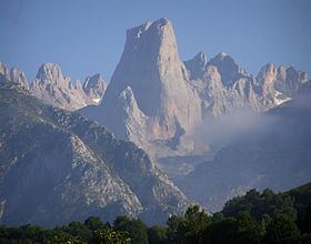
Peak Torre de Cerredo State/Province Iberian Peninsula Area 646 km² | Elevation 2,650 m Highest point Torre de Cerredo | |
 | ||
Similar Naranjo de Bulnes, Torre de Cerredo, Torre Santa, Peña Vieja, Sierra del Sueve | ||
The Picos de Europa (literally: "Peaks of Europe", often abbreviated in English to the Picos) is a range of mountains 20 km inland from the northern coast of Spain, in the Autonomous Communities of Asturias, Cantabria and Castile and León; they are part of the Cantabrian Mountains. A widely accepted origin for the name is that they were the first sight of Europe for ships arriving from the Americas.
Contents
- Map of Picos de Europa 33554 Asturias Spain
- Picos de europa highlights hd
- Geography
- Nature
- Caves
- Gastronomy
- References
Map of Picos de Europa, 33554, Asturias, Spain
Picos de europa highlights hd
Geography
The range consists of three major massifs: Central (also known as Urrieles), Eastern (Ándara) and Western (also known as the Picos de Cornión). The Central and Western massifs are separated by the 1.5 kilometres (0.93 mi) deep Cares Gorge (Garganta del Cares), with the village of Caín at its head. The waters in the Cares mostly arise from cave resurgences. Some of the water in the Cares river is diverted through a hydroelectric scheme, with a canal running in the northern wall of the gorge to Camarmeña. An access path next to the canal provides a spectacular walk.
Almost all of the rock in the Picos is limestone, and glacial action has contributed to create an impressive area of alpine karst. The highest peak is Torre de Cerredo, with an altitude of 2,650 metres at 43°11′51″N 4°51′06″W. Many other peaks reach altitudes of over 2,600 m. The area is popular with mountaineers, climbers and mountain walkers. There is a good network of well-established mountain refuges. The best-known climbing site is the Naranjo de Bulnes or Picu Urriellu, in the Urrieles massif which can be considered the most famous climb in Spain.
Nature
Cantabrian brown bears (Ursus arctos pyrenaicus) and wolves (Canis lupus signatus) live in the more remote regions. Rebeccos (Cantabrian chamois - Rupicapra pyrenaica parva) are fairly frequently seen (according to a 2006 Ministry of the Environment report, there were around 8,000 sightings that year); choughs and buzzards are common, various eagles and vultures are frequently seen, and there is a diverse butterfly population in the park.
Most of the region is now protected as a single Picos de Europa National Park in Cantabria, Asturias and León provinces of Spain; the Asturian part was Spain's first National Park. Access is via minor roads to each of the three massifs from the north and from the south to the aerial tramway at Fuente Dé and to Caín at the head of the Cares Canyon.
Caves
The Picos de Europa contain many of world's deepest caves, including Torca del Cerro (−1589 m), Sima de la Cornisa (−1507 m), Torca los Rebecos (−1255 m) and Pozo del Madejuno (−1252 m). Discovery of new caves and their exploration still continues.
Gastronomy
The Picos support a dwindling group of shepherds who move up from the valleys in the summer with their sheep, goats, cows, and an occasional pig. The area is famed for its piquant blue cheeses, such as Cabrales cheese and Picón Tresviso Bejes.
