
Country Spain Elevation 550 m (1,800 ft) Time zone CET (UTC+1) Area 85.4 km² Local time Wednesday 9:26 PM | Demonym(s) Arnedanos Postal code 26580 Province La Rioja Community La Rioja | |
 | ||
Weather 9°C, Wind SW at 3 km/h, 77% Humidity | ||
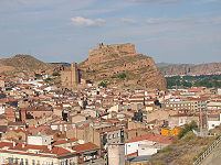
Arnedo is the third largest town in La Rioja, Spain. It is located near Calahorra, and has a population of about 15,000 people.
Contents
Map of 26580 Arnedo, La Rioja, Spain
Its economy is based on the shoe industry.
History
The area of Arnedo has been inhabited as early as the Neolithic Age. In pre-Roman times it was known as Sadacia or Sidacia, while the current name derives from the Latin Arenetum ("Place of sand"); the Romans, who arrived here in the 2nd century BC replacing the Celtiberians, built here a fortification to defend the hill, which commanded an important communication hub. Of the Visigothic Age are remains of a 6th-century cave-church.
The Moors conquered Arnedo in the 8th century AD and made it the capital of one of the 26 provinces in which they divided Iberia. The town was conquered by the Christian king Sancho I of Pamplona in 908-909.