
Founded 1836 Area 1,132 km² | Website www.henrycountyiowa.us Population 20,222 (2013) | |
 | ||
Cities Rivers Skunk River, Big Creek, Brush Creek, Wolf Creek Points of interest Swedish Heritage Museum, Theatre & Museum, Harlan‑Lincoln House, Midwest Electric Railway, Mt Pleasant Parks & R | ||
Henry County is a county located in the U.S. state of Iowa. As of the 2010 census, the population was 20,145. The county seat is Mount Pleasant. The county was named for General Henry Dodge, governor of Wisconsin Territory.
Contents
- Map of Henry County IA USA
- History
- Geography
- Major highways
- Adjacent counties
- 2010 census
- 2000 census
- Unincorporated communities
- Population ranking
- References
Map of Henry County, IA, USA
History
Henry County was formed on December 7, 1836 under the jurisdiction of Wisconsin Territory, and became a part of Iowa Territory when it was formed on July 4, 1838. It was named for General Henry Dodge.
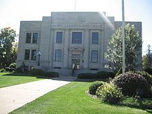
In 1839, construction of the first courthouse was begun and completed in 1840. In 1871, construction of a second courthouse began and on August 4, 1914, the third courthouse was completed which is still presently used as such.
Geography
According to the U.S. Census Bureau, the county has a total area of 437 square miles (1,130 km2), of which 434 square miles (1,120 km2) is land and 2.2 square miles (5.7 km2) (0.5%) is water.
Major highways
Adjacent counties
2010 census
The 2010 census recorded a population of 20,145 in the county, with a population density of 47.4625/sq mi (18.3254/km2). There were 8,280 housing units, of which 7,666 were occupied.
2000 census
As of the census of 2000, there were 20,336 people, 7,626 households, and 5,269 families residing in the county. The population density was 47 people per square mile (18/km²). There were 8,246 housing units at an average density of 19 per square mile (7/km²). The racial makeup of the county was 94.78% White, 1.49% Black or African American, 0.24% Native American, 1.88% Asian, 0.02% Pacific Islander, 0.52% from other races, and 1.07% from two or more races. 1.26% of the population were Hispanic or Latino of any race.
There were 7,626 households out of which 32.80% had children under the age of 18 living with them, 57.70% were married couples living together, 8.20% had a female householder with no husband present, and 30.90% were non-families. 26.80% of all households were made up of individuals and 12.20% had someone living alone who was 65 years of age or older. The average household size was 2.46 and the average family size was 2.98.
In the county, the population was spread out with 24.70% under the age of 18, 9.00% from 18 to 24, 29.20% from 25 to 44, 22.50% from 45 to 64, and 14.70% who were 65 years of age or older. The median age was 37 years. For every 100 females there were 102.50 males. For every 100 females age 18 and over, there were 102.80 males.
The median income for a household in the county was $39,087, and the median income for a family was $46,985. Males had a median income of $31,801 versus $23,075 for females. The per capita income for the county was $18,192. About 6.70% of families and 8.80% of the population were below the poverty line, including 10.30% of those under age 18 and 9.30% of those age 65 or over.
Unincorporated communities
Population ranking
The population ranking of the following table is based on the 2010 census of Henry County.
† county seat