
Country United States FIPS code 19-84835 Elevation 213 m Population 113 (2013) | Time zone Central (CST) (UTC-6) GNIS feature ID 1669486 Area 39 ha Local time Saturday 8:57 AM | |
 | ||
Weather 4°C, Wind N at 8 km/h, 91% Humidity | ||
Westwood is a city in Henry County, Iowa, United States. The population was 112 at the 2010 census.
Contents
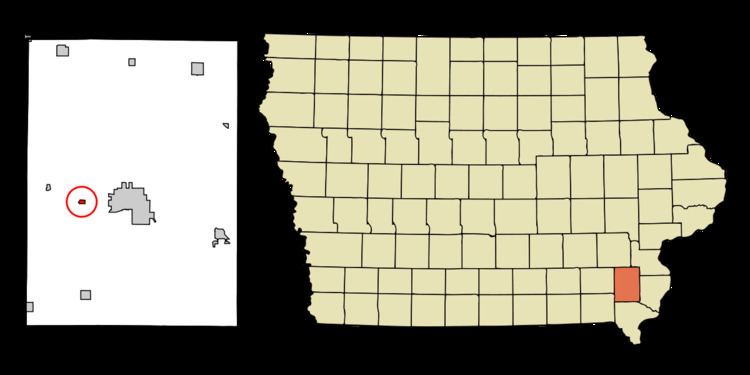
Map of Westwood, IA 52641, USA
Geography
Westwood is located at 40°57′51″N 91°37′42″W (40.964172, -91.628272).
According to the United States Census Bureau, the city has a total area of 0.15 square miles (0.39 km2), all of it land.
2010 census
As of the census of 2010, there were 112 people, 47 households, and 38 families residing in the city. The population density was 746.7 inhabitants per square mile (288.3/km2). There were 47 housing units at an average density of 313.3 per square mile (121.0/km2). The racial makeup of the city was 100.0% White.
There were 47 households of which 23.4% had children under the age of 18 living with them, 78.7% were married couples living together, 2.1% had a female householder with no husband present, and 19.1% were non-families. 14.9% of all households were made up of individuals and 12.8% had someone living alone who was 65 years of age or older. The average household size was 2.38 and the average family size was 2.66.
The median age in the city was 56 years. 19.6% of residents were under the age of 18; 1.8% were between the ages of 18 and 24; 11.7% were from 25 to 44; 41.9% were from 45 to 64; and 25% were 65 years of age or older. The gender makeup of the city was 47.3% male and 52.7% female.
2000 census
As of the census of 2000, there were 127 people, 46 households, and 43 families residing in the city. The population density was 835.1 people per square mile (326.9/km²). There were 47 housing units at an average density of 309.1 per square mile (121.0/km²). The racial makeup of the city was 96.06% White, 0.79% African American, and 3.15% from two or more races.
There were 46 households out of which 34.8% had children under the age of 18 living with them, 93.5% were married couples living together, and 6.5% were non-families. 6.5% of all households were made up of individuals and 4.3% had someone living alone who was 65 years of age or older. The average household size was 2.76 and the average family size was 2.86.
In the city, the population was spread out with 23.6% under the age of 18, 3.9% from 18 to 24, 13.4% from 25 to 44, 46.5% from 45 to 64, and 12.6% who were 65 years of age or older. The median age was 49 years. For every 100 females there were 104.8 males. For every 100 females age 18 and over, there were 98.0 males.
The median income for a household in the city was $89,522, and the median income for a family was $90,571. Males had a median income of $63,438 versus $28,750 for females. The per capita income for the city was $33,677. None of the population and none of the families were below the poverty line.