
Population 332 (2011) Civil parish Hemblington Area 3.03 km² | OS grid reference TG353115 Sovereign state United Kingdom Local time Thursday 12:43 PM | |
 | ||
Weather 13°C, Wind W at 34 km/h, 54% Humidity | ||
Hemblington is a civil parish in the English county of Norfolk, about 8 miles (13 km) miles east of Norwich. It covers an area of 3.03 km2 (1.17 sq mi) and had a population of 316 in 134 households at the 2001 census, increasing to a population of 332 in 146 households at the 2011 Census. For the purposes of local government, it falls within the district of Broadland. As well as the village of Hemblington the parish includes the hamlet of Pedham some 1 1⁄2 miles (2 km) to the northwest.
Contents
Map of Hemblington, UK
The Domesday Book records Hemblington as Hemelingetun.
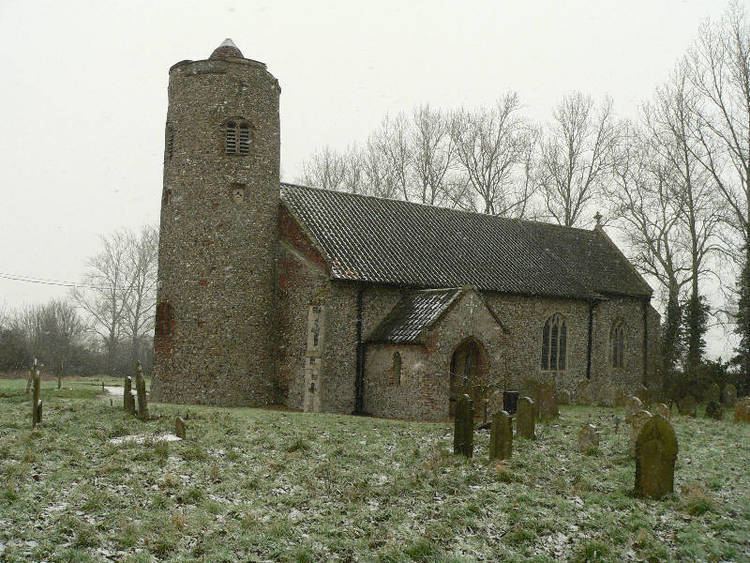
Church of All Saints
The Church of England parish church of All Saints is in the deanery of Blofield and is one of 124 existing round-tower churches in Norfolk. There is a famous 15th-century painting of St Christopher inside the church, which was uncovered and restored by Professor E. W. Tristram of the Victoria and Albert Museum in 1937. It is a Grade I listed building.
Hemblington Hall
Hemblington Hall is a grade II listed Georgian house dating from c.1700.