
Vehicle registration JH Population 1.026 million (2011) | Time zone IST (UTC+5:30) Area 5,327 km² ISO 3166 code ISO 3166-2:IN | |
 | ||
Administrative division | ||
Modi credits nda govt for jharkhand creation at rally in gumla
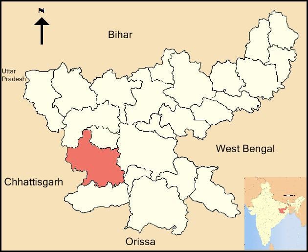
Gumla district is one of the twenty-four districts of Jharkhand state, India, and Gumla town is the administrative headquarters of this district.
Contents
- Modi credits nda govt for jharkhand creation at rally in gumla
- Etymology
- BlocksMandals
- History
- Geography
- Climate
- Economy
- Demographics
- Languages
- Culture
- Tourist attractions
- Flora and fauna
- References
Etymology
For centuries, the place was a meeting center for people from the hinterland who flocked here to exchange goods using the barter system, and the place was called Gaw-Mela. Gumla is believed to derive its name from Gaw-Mela, which consists of two words of Hindi (also used in several local dialects), namely, Gaw (cows and the cattle) and Mela, that is, a fair. The place became known as Gaw-mela, and then the word transformed itself into Gumla.
Blocks/Mandals
Gumla district consists of 12 Blocks. The following are the list of the Blocks in Gumla district:
History
During British rule Gumla was under Lohardaga district. In 1843 it was brought under Bishunpur province that was further named Ranchi. In fact Ranchi district came into existence in 1899. In 1902 Gumla became Sub-division under Ranchi district. On 18 May 1984 Gumla District came into existence. Sri Jagannath Mishra then ruling Chief Minister of Bihar inaugurated it and Sri Dwarika Nath Sinha acquired the post of 1st deputy commissioner of the just born district.
Gumla is considered to be the birthplace of the Hindu God Hanuman. A temple a few kilometers away from the city off the Gumla-Ghaghra road is dedicated to him and his mother. The district contains mountains named "Risyamook", which are mentioned in the Ramayana.
The district is currently a part of the Red Corridor.
The Gumla District had a place in the middle of the town called (Bazar Tanr), still there, where people used to bring their animals, mostly cows, and this way the fair was called [Gow-Mela] (a fair of cows). So this is how it is called Gumla.
Geography
Gumla is located at 23°N 84.50°E / 23; 84.50. Geographically, Gumla is located on southern part of the Chota Nagpur plateau which forms the eastern edge of the Deccan plateau system.
There are three major rivers, which flow through the Gumla district viz. the South Koel, the North Koel and the Sankh. There are various streams/ tributaries to the main rivers on which there are some picturesque waterfalls, as for example Sadni Falls.
The terrain is highly undulating and there are existence of many rivers and streams. The forest cover of the district is 1.35 lakh hectares out of the total 5.21 lakh hectares of land i.e. round 27% of the total area of the district.
Climate
Gumla district enjoys a good climate characterized by a pleasant cold and temperate weather conditions. Gumla has a sub-tropical climate. Temperature ranges from maximum 40 to 20 °C during summer, and minimum 21 to 3 °C during winter. The annual rainfall is about 1450 mm. From June to September the rainfall level is about 1,150 mm.
Economy
Gumla district has rich natural and mineral resources. There are 23 bauxite mines and 68 stone mines in Gumla district. Besides these there is good number of brick makers. In Gumla District the important minerals like bauxite and laterite (aluminium ore) are found in villages of Amkipani, Langdatanr, Chirodih, Jalim, Narma, Bahagara and Gurdari of Bishunpur block, Langatanr, Lupungpat and Chota-Agiatu in Chainpur block and Harup, Serengdag and Jalim in Ghaghra block. Beside these china clay is also found in some part of the district. Other mining activities like stone crusher, Brick kiln and stone chip mining lease are also available in different part of the district.
In 2006 the Indian government named Gumla one of the country's 250 most backward districts (out of a total of 640). It is one of the 21 districts in Jharkhand currently receiving funds from the Backward Regions Grant Fund Programme (BRGF).
Demographics
According to the 2011 census Gumla district has a population of 1,025,656, roughly equal to the nation of Cyprus or the US state of Montana. This gives it a ranking of 439rd in India (out of a total of 640). The district has a population density of 193 inhabitants per square kilometre (500/sq mi) . Its population growth rate over the decade 2001-2011 was 23.21%. Gumla has a sex ratio of 993 females for every 1000 males, and a literacy rate of 66.92%.
As of 2011 India census, Gumla had a population of 1,025,656 which is 3.11% of total Jharkhand Population. Out of total 1,025,656: 514,730 are males and 510,926 are female; this makes the sex ratio of Gumla 993, which better than India's sex ratio. Gumla has an average literacy rate of 66.92%. In Gumla, 15% of the population is under 6 years of age.
Languages
The major languages spoken in this region of Jharkhand are Hindi, Ho, Nagpuri or Sadri, Odia & Kurukh.
Languages spoken here also include Asuri, an Austroasiatic language spoken by approximately 17,000.
Languages like Khortha, Oraon, Kudukh, and Mundari are also spoken in Tribal areas Of Gumla District.
Culture
Gumla has a Rich Aadiwasi culture and is colourful with the shades of nature. "Chhotanagpur ki raani", a hill station is located in this district.
Gumla has a rich tribal culture. The majority of people (about 80%) speak Nagpuri, but Hindi is used for communicating with non-tribal people.
Tourist attractions
There is a gufa which is said to be used by Pandavas,during epic Mahabharata.
it is said that maa sita makes powder of turmeric and some stones (big pieces) of this place are still found in yellow color.
Flora and fauna
It is home to a variety of flora and fauna.