
Primary inflows Max. width 1.25 km (0.78 mi) Area 15.64 km² Mean depth 64 m | Max. length 18 km (11 mi) Surface area 15.64 km (6.04 sq mi) Surface elevation 984 m Length 18 km Inflow source Muru | |
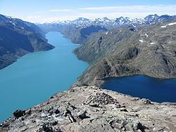 | ||
Gjende (or Gjendin) is a lake in the Jotunheimen mountains in Norway's Jotunheimen National Park. The proglacial lake shows typical characteristics of glacial formation, being long and narrow, with steep walls—18 km in length and only 1.5 km in width at the broadest point. Gjende has a characteristic light-green color resulting from the large quantity of rock flour which is discharged into the Gjende by the Muru river. The river Sjoa provides the outlet from Gjende at Gjendesheim, and flows eastward into the Gudbrandsdalslågen river.
Contents
Map of Gjende, 2683 Tessanden, Norway
Gjende lies in the middle of Jotunheimen National Park and both to the north and south of the lake lie peaks greater than 2,000 m. There are numerous staffed tourist cabins maintained by the Norwegian Mountain Touring Association (DNT); in the west end lies Gjendebu, on the north side lies Memurubu and on the east end lies Gjendesheim. In the summer boats provide transport between these locations.
NameEdit
The name (Old Norse *Gendir) is derived from Norse gandr m 'staff, stick'. This is referring to the form of the long and narrow lake.
See also Bygdin