
Surface area 46 km (18 sq mi) Surface elevation 1,057 m Length 25 km | Max. length 25 km (16 mi) Max. depth 215 m (705 ft) Area 46 km² | |
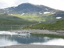 | ||
Bygdin is a lake in the Jotunheimen mountain range. Bygdin is regulated and its normal level lies between 1,048 and 1,057 meters above sea level. It has an area of 46 km². The lake is long 25 km, but is narrow. The greatest depth is 215 m.
Contents
Map of Bygdin, Vang Municipality, Norway
Bygdin lies to the southeast in Jotunheim and north of the lake lies an area over 2,000 m. Along the lake there are many tourist huts – on the west end lies Eidsbugarden, on the north side lies Torfinnsbu and on the east side lies Bygdin turisthytte. In the summer these huts are connected by boat and in winter by ski or snowmobile. A memorial was raised in 1909 to the Norwegian poet Aasmund Olavsson Vinje at the western end of Lake Bygdin at Eidsbugarden on the outskirts of Jotunheim National Park where he had a private hut. Friends and followers commemorated his contribution to appreciation of Norwegian nature and strengthening of the Norwegian national identity. Today Eidsbugarden is a rather large mountain tourist centre, with a hotel from 1909 which is being restored to reopen in the summer 2007, a Norwegian Mountain Touring Association (DNT) cabin and approximately 160 private huts.
The Vinsteråni river runs out Bygdin, passes through Vinstervatna and Vinstra lakes and flows into the Gudbrandsdalslågen river.
Name
The name (Old Norse *Bygðir) is derived from Norse bugr m 'bending, nook, bay'. This is referring to the "bent" form of the lake.
See also Gjende.