
Length 250 km | ||
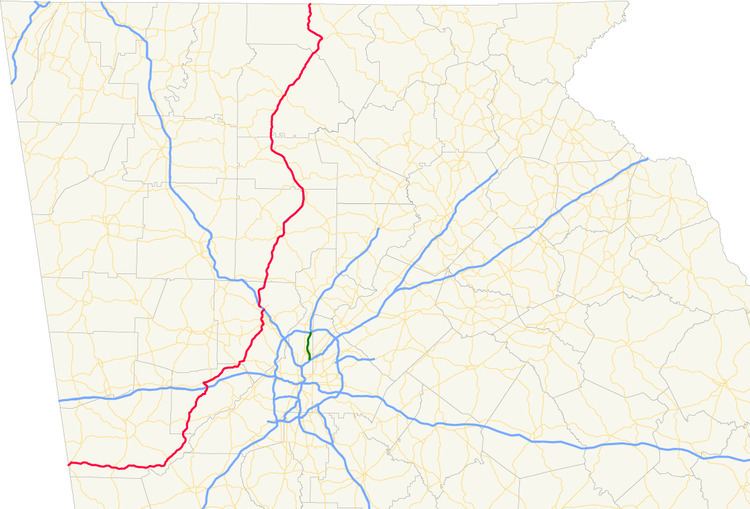 | ||
State Route 5 (SR 5) is a 155.325-mile-long (249.971 km) state highway that travels south-to-north through portions of Carroll, Douglas, Cobb, Cherokee, Pickens, Gilmer, and Fannin counties in the western and northern parts of the U.S. state of Georgia. The highway travels from its southern terminus at SR 48 at the Alabama state line, north-northwest of Ephesus, to its northern terminus at SR 60 and SR 68 at the Tennessee state line on the McCaysville–Copperhill line, bisecting the northwestern portion of the state.
Contents
- Map of GA 5 Georgia USA
- Route description
- Traffic
- Old Highway 5
- Original route development 1920s to 1960s
- Development of I 575 Late 1970s to present day
- Georgia designated roadways
- Marietta spur route
- Kennesaw connector route
- Canton business loop
- Canton connector route
- Ball Ground business loop
- Gilmer County alternate route
- References
Map of GA-5, Georgia, USA
Route description
SR 5 starts at the Alabama state line just east of Graham and north-northwest of Ephesus, in Carroll County, where the highway continues west into Randolph County, Alabama as SR 48. In Carroll County, the highway initially travels northeast, but soon turns to the east, and bisects the southern portion of rural Carroll County. SR 5 crosses U.S. Route 27/SR 1 (US 27/SR 1) in Roopville, and continues east until it nears the Chattahoochee River, where it turns northeast to parallel the river, and travels through Whitesburg. SR 5 continues northeast, then cuts north into Douglas County, where it is locally known as Bill Arp Road, crosses Interstate 20 (I-20) in Douglasville.
Continuing northeast, and having picked up a concurrency with US 78/SR 8, the highway heads through Lithia Springs, crosses US 278/SR 6, and enters Cobb County and Austell. In Austell, SR 5 splits from US 78/SR 8 and heads slightly northeast through the western parts of Smyrna to just west of Dobbins Air Reserve Base. Traveling concurrently with SR 280, the highways wind to the north around Dobbins as South Cobb Drive, and SR 5 splits off and travels to the north by itself into Marietta as Atlanta Road. The highway then makes a sharp turn to the west and travels concurrently with SR 120 Loop, and both turn north again to just avoid the Marietta Square to its west.
Curving to the northeast past the square, SR 5 leaves its concurrency with SR 120 Loop behind and heads north yet again, first as Cherokee Street, then Church Street, and curves to the northeast as it crosses US 41/SR 3. Soon thereafter, SR 5 merges with I-75 for a very short distance, and then splits off I-75 north of Marietta, together with its concurrency with I-575, and heads north and northeast into Cherokee County in the direction of Woodstock. From Marietta to Blue Ridge, the route parallels the Marietta and North Georgia Rail Line.
SR 5 remains concurrent with I-575 for that route's entire length, as the two highways bisect Cherokee County, and bypass Holly Springs, Canton (crossing the Etowah River north of Canton), and Ball Ground. North of Ball Ground, near Nelson, I-575, as well as the freeway portion of the highway, terminates, and SR 5, now concurrent with SR 515, enters Pickens County. The highways curve northwest around Jasper, then turn back to the north near Talking Rock on their way into Gilmer County and Ellijay. In East Ellijay, SR 5 picks up a concurrency with US 76/SR 2, and heads northeast into the Chattahoochee National Forest in the direction of Blue Ridge in Fannin County. In Blue Ridge, US 76/SR 2/SR 515 head off to the east, while SR 5 heads northwest to McCaysville and its northern terminus at the Tennessee state line, where the route intersects the northern terminus of SR 60 (Toccoa Avenue) and continues into Tennessee as SR 68 (which also has the Toccoa Avenue name).
Traffic
The Georgia Department of Transportation (GDOT) average annual daily traffic (AADT) numbers for the year 2011 show a variety of average daily traffic load numbers as the route travels across western and northern Georgia. At the route's western portion in rural Carroll County, daily vehicle load averages hover around 3,000, with a route low seen west of US 27 at just over 1,000 vehicles per day. Averages quickly rise from about 7,500 vehicles north of SR 166 to reach numbers near 22,000 around I-20, then level off between 10,000 and 15,000 between Douglasville and Austell. Vehicle loads climb again north of Austell, reaching numbers between 27,000 and 38,000 between Austell and Marietta.
Once SR 5 becomes concurrent with I-575, averages increase drastically, with a route high of 93,000 vehicles seen south of Woodstock, close to I-75. Numbers generally decrease as the route travels further north, going from the mark seen in Woodstock down to 59,000 in Holly Springs, around 55,000 in Canton, and further down to 26,000 near Ball Ground. Once the freeway portion of the route ends in Pickens County, averages fall further from around 24,000 to around 12,000, but stabilize in that vicinity from Talking Rock in Pickens County all the way through Ellijay in Gilmer County to Blue Ridge in Fannin County. As SR 5 approaches its northern terminus, vehicle load decreases once more to a low of 7,200, and hovers around 9,000 as the Tennessee state line is reached.
"Old Highway 5"
With the construction of I-575 and other projects between Cobb and Gilmer counties, SR 5 saw significant routing changes in the 1980s and 1990 (see History below for additional details). All of the former routing of SR 5, parallel to I-575, and the new routing in Pickens and Gilmer counties, still exists today, and is utilized by local traffic.
From the northbound exit 267A on I-75, the old routing of SR 5 follows what is today locally known as Canton Road Connector (and is signed as SR 5 Spur), which merges into Canton Road. This routing parallels I-575 very closely to its east as the old SR 5 routing heads north through the heart of Woodstock. The local road name changes to Main Street through Woodstock, and to Holly Springs Parkway on its way to Holly Springs, where it crosses under I-575 to its west at exit 14. As the old route travels through Canton, it becomes briefly concurrent with SR 140 (and is signed as SR 5 Bus.), then crosses under I-575 once more to its east again (at exit 20), and heads northeast as Ball Ground Highway. Rarely more than 0.5 miles (0.80 km) separate the old routing and I-575/SR 5/SR 515, as the old SR 5 passes through the heart of Ball Ground (where it is again signed as SR 5 Bus.), and it briefly becomes concurrent with SR 372.
"Old Highway 5" continues north as Canton Road/Canton Highway, now somewhat further removed from the current SR 5, and travels through Nelson, then becomes concurrent with SR 53 Bus. into Jasper. North of Jasper, the former routing of SR 5 has become a minor roadway and is known as Talking Rock Road to Talking Rock, where it briefly becomes concurrent with SR 136, then heads north as Ellijay Road, having crossed to the west of the current SR 5 together with SR 136. Paralleling SR 5 very closely once more, the former routing travels through downtown Ellijay, crosses the Ellijay River, and merges into the current US 76/SR 5/SR 515 north of East Ellijay.
Original route development: 1920s to 1960s
SR 5 makes its appearance on Georgia state road maps in 1920, when the portion of the route from Marietta, at its intersection with SR 3, to the Tennessee state line is graded and designated as SR 5, with the stretch from the northern parts of Pickens County to Blue Ridge concurrent with SR 2. It should be noted that the original routing of SR 5 traveled through, not around, the communities of Holly Springs, Canton, and Ball Ground, and curved through Nelson and Tate to head through Jasper and points north. In addition, the portion of the route where SR 5 is concurrent with US 78 and SR 8, from Douglasville to Austell, was also extant at the time, and signed as SR 8. By the middle of 1936, no other portions of the roadway had been constructed; however, all of the existing routing that was signed as SR 5 (between Marietta and Tennessee) had been finished with hard surface at this time.
Less than a year later, by early 1937, a connection measuring 10.9 miles (17.5 km) between Powder Springs and Marietta had been graded and designated as part of SR 5. This roadway, which today corresponds to Powder Springs Road, and which is partially designated as SR 360, does not cover the same route as the present path of SR 5, but is north of today's route. By late in 1940, another portion of today's routing made its first appearance with the addition of the spur measuring 23.0 miles (37.0 km) between Whitesburg and Douglasville, which also received a designation of SR 5.
By early in 1941, numerous changes had taken place, in particular in the southern and western portion of the route. A connecting roadway measuring 5.8 miles (9.3 km), and designated as part of SR 5 at the time, had been constructed from the Alabama state line to Bowdon; this roadway is designated as part of SR 100 today. In the same area, and also designated as part of SR 5, was a new roadway running from Roopville to Whitesburg, which does correspond to part of today's route. This routing connected west and north to Bowdon via a section of today's SR 5 running west from Roopville, which then curves northwest in the direction of Bowdon, and which is today known as Bowdon-Tyus Road, but appeared to be part of SR 5 at the time.
In 1949, the westernmost portion of SR 5 started to follow its current alignment, where SR 5 starts at the Alabama state line and runs east to the community of Bucktown, instead of northeast to Bowdon. The new routing then continues east to where SR 100 splits off to the northeast, and heads still further east to meet the existing section of SR 5 at its intersection with Bowdon–Tyus Road. At the time, the entire portion from the Alabama state line to Douglasville was still in an unimproved state from a road surface perspective. By 1953, the first indication of the one missing section of the route, between Austell and Marietta, was first mapped as a connecting county route, and it was ten more years before this connection was made part of the state route system, when this section was designated as SR 340. Even then, portions of the route east of the Alabama state line and west of Whitesburg were still not covered in hard surface.
Development of I-575: Late 1970s to present day
By early in 1980, I-575 had been under construction for some time (designated as SR 713 during the construction period), and two other construction projects were underway between Cherokee County and Gilmer County. In Gilmer County, the project designated as SR 719 was aimed at re-routing SR 5 around Ellijay to its east. In 1982, SR 5 was re-routed from the Cherokee–Pickens county line to its present path; this project was also designated as SR 713 while under construction. This meant that SR 5, as before, traveled northeast through Ball Ground, but then made a sharp turn to the northwest, utilizing what today is the northernmost stretch of SR 372, to meet the current SR 5 routing just inside Pickens County. This new routing bypasses Nelson and Tate altogether (this section is called Canton Highway today), and also bypasses Jasper to its west (the old routing from Jasper is utilized by SR 53 Business today, and the entire stretch was signed as SR 5 Alt. until 1987), and connects to the existing SR 5 routing in Talking Rock (that portion is presently known as Talking Rock Road). Running north from Talking Rock, the original routing is currently known as Ellijay Road, and closely parallels the present SR 5/SR 515, heads through the heart of Ellijay, and intersects US 76/SR 5/SR 515 northeast of Ellijay.
In 1984, the portion of the road that had been signed as SR 340 between Austell and Marietta had been re-designated as SR 5, and the roadway traveling northeast from Powder Springs had been dropped from the state route system. In addition, the southern portion of I-575, from north of Marietta to Canton, had been put into operation, but SR 5 in the area was kept in the state route system, traveling closely parallel to the new interstate. Also, another portion of the newly constructed route around Ellijay (tracked as SR 719 while under construction) was put into operation, and the original routing was re-designated as SR 5 Alt.
By early in 1986, the portion of SR 5 traveling parallel to I-575 from Marietta to Canton had been re-designated as SR 754. Around Ellijay, the designation of SR 5 Alt. was dropped, meaning that the original routing in that area was dropped from the state route system at this time. Just another year later saw the re-designation of SR 5 to be concurrent with the new I-575, which had been put into operation for its entire length between I-75 near Marietta and Pickens County. This meant that the entire stretch of original routing of SR 5, from north of Marietta to north of Ellijay, had been removed from the state route system (with the exception of several special routes, described below), and had been replaced by four-lane limited-access new highway construction. At this same time, SR 5 in north Marietta, which had crossed I-75 and continued north by itself, was merged into I-75 for a very short distance, before SR 5, together with I-575, split off to the north on its present path. The designation of SR 515, concurrent with SR 5 from Pickens County to Blue Ridge, did not appear until early in 1990.
Georgia designated roadways
On March 28, 1988, SR 5 was designated as "Chieftains Trail" between Canton and Ellijay.
On April 28, 1999, SR 5 was designated as "C. F. 'Coote' Mason Highway" between the end of its concurrency with SR 515 and its northern terminus.
In 2005, the interchange between SR 5 and SR 515 in Blue Ridge was designated as the "A. L. Stepp Interchange".
Marietta spur route
State Route 5 Spur starts where the SR 5 main line merges into I-75 at exit 267B in Marietta, and runs northeast, locally known as the Canton Road Connector. It terminates where Canton Road and Canton Road Connector merge, and the roadway continues north as Canton Road.
Kennesaw connector route
State Route 5 Connector starts at the intersection of Barrett Parkway and US 41/SR 3 in Kennesaw, less than 1 mile (1.6 km) northwest of where the SR 5 main line crosses the same two routes. SR 5 Connector heads northeast, locally known as Barrett Parkway on both sides of that intersection, and crosses I-75 just before passing by Town Center Mall. The connector terminates just east of its intersection with I-575/SR 5, where the roadway continues east as Piedmont Road.
Canton business loop
State Route 5 Business starts where SR 140 makes a sharp turn from the east to the north, and turns from Marietta Highway to Waleska Road, just west of I-575/SR 5 in Canton. The route runs slightly northeast from this intersection through the northern parts of Canton, is locally known as Riverstone Parkway, and terminates at its intersection with I-575/SR 5 at exit 20.
Canton connector route
State Route 5 Connector (SR 5 Conn.) is a 1.4-mile-long (2.3 km) connecting route of SR 5 in the central part of Canton. It is known as Reinhardt College Parkway for its entire length. It is signed as a north–south highway, but it appears to be backward, since its "southern" terminus is north of its "northern" terminus. It begins at an intersection with SR 140. It travels to the east-southeast and curves to the east-northeast. It passes by some residential neighborhoods before curving to the south-southeast. It passes the Riverstone Village shopping center. It then curves to the southeast, passing the RiverStone Medical Center. Just before its northern terminus, it travels between the Mainstreet at RiverStone and RiverStone Plaza shopping centers. It meets its northern terminus, an intersection with SR 5 Bus. (RiverStone Parkway).
The entire route is in Canton, Cherokee County.
Ball Ground business loop
State Route 5 Business starts at exit 27 of I-575/SR 5 in Ball Ground, where the roadway continues west as Howell Bridge Road. The route heads slightly southeast for a very short distance, then turns sharply northeast to run into the heart of Ball Ground on the former routing of SR 5. The business route terminates at its intersection with SR 372, which carries the roadway north to again merge into the SR 5 main line.
Gilmer County alternate route
State Route 5 Alternate (SR 5 Alternate) was an 8.3-mile-long (13.4 km) alternate route that existed entirely within the central part of Gilmer County. Its entire route was the former alignment of the SR 5 mainline through the area, before SR 5 was shifted to a new route east of this one.
It began south-southwest of Ellijay, where the original route of the SR 5 mainline (SR 515 had not been routed through the area at that time) continued to the south-southwest. This intersection also marked the eastern terminus of SR 382. The two highways headed north-northeast and diverge, with SR 5 Alternate continuing to the north-northeast. After a crossing of the Coosawattee River, it entered Ellijay and intersected US 76/SR 282. In the main part of town, it intersected SR 52. Then, it entered the Chattahoochee-Oconee National Forest and curved to the east-northeast and met its northern terminus, an intersection with US 76/SR 5.