
Website www.cherokeega.com Founded 1831 | Area 1,124 km² Population 225,106 (2013) | |
 | ||
Points of interest Lake Arrowhead, Gibbs Gardens, Hobgood Park, Olde Rope Mill Park, Blankets Creek Mountain Destinations | ||
Cherokee County is a county located in the US state of Georgia. As of the 2010 census, the population was 214,346. The county seat is Canton. The county Board of Commissioners is the governing body, with members elected to office.
Contents
- Map of Cherokee County GA USA
- Original territory
- Remaining county
- Development
- Geography
- Government
- Mountains
- Adjacent counties
- 2000 census
- 2010 census
- Public Schools
- Private schools
- Higher education
- Airport
- Public transportation
- Notable residents
- References
Map of Cherokee County, GA, USA
The county is under the jurisdiction of the Cherokee County Sheriff's Office, which is headed by Sheriff Frank Reynolds. The Cherokee County Sheriff's office is accredited by CALEA. The major cities within the county have individual police departments, such as Woodstock, Canton, Holly Springs, and Ball Ground.
Cherokee County is included in the Atlanta-Sandy Springs-Roswell, GA Metropolitan Statistical Area.
Original territory
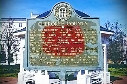
Originally, Cherokee County was more like a territory than a county, covering everything northwest of the Chattahoochee River and Chestatee River except for Carroll County. This county was created December 26, 1831 by the state legislature. It was named after the Cherokee Indians who lived in the area at that time. Several other counties were carved out of these Cherokee lands as part of the Cherokee Land Lottery of 1832.
An act of the Georgia General Assembly passed on December 3 of that year created the counties of Forsyth, Lumpkin, Union, Cobb, Gilmer, Murray, Cass (now Bartow), Floyd, and Paulding. The forcible (sometimes at gunpoint) removal of the Cherokee people, leading up to the notorious Trail of Tears to Indian Territory west of the Mississippi River, began in this area the year before. The push by European Americans to expel the Cherokee was accelerated by the discovery of gold in local streams.
County courts were authorized to meet at the home of Ambrose Harnage. The settlement soon became known as Harnageville, later called Marble Works, and even later Tate, when Cherokee County was first established. Since 1880 that town has been called Tate, and it is now (since 1853) in Pickens County. Part of that county was taken directly from Cherokee, the other via Gilmer County (itself earlier taken from Cherokee).
Etowah was named the first county seat in 1833. Its name was later changed to Canton.
Remaining county
In 1857, part of the southeastern corner of the county was ceded by the General Assembly to form Milton County (now the city of Milton in the county of Fulton). In the 1890s, The Atlanta & Knoxville Railroad (later renamed the Marietta & North Georgia Railroad when it could not be completed to Knoxville) built a branch line up through the middle of the county. When this line was bought by the Louisville & Nashville Railroad the following decade, the L&N built railroad stations at Woodstock and other towns.
Development
Since the late 20th century, Cherokee County has been part of the Atlanta metro area. It is bisected by Interstate 575, which runs from Marietta north through Woodstock, Lebanon, Holly Springs, Canton, the county seat, and Ball Ground, ending at the Pickens County line into Georgia 515, the Appalachian Parkway developmental highway. Interstate 575 is undergoing significant widening to accommodate growth in Cherokee County population.
The Georgia Northeastern Railroad operates freight service on the former L&N tracks, roughly parallel to this route. Population growth has followed the same general pattern as well, with new suburbs in the south following the highway toward exurbs further north.
Geography
According to the U.S. Census Bureau, the county has a total area of 434 square miles (1,120 km2), of which 422 square miles (1,090 km2) is land and 13 square miles (34 km2) (2.9%) is water. Much of the water is in Lake Allatoona in the southwest. The lake is fed by the Etowah and Little rivers (the county's primary waterways), and other large streams such as Noonday Creek. Much of the northern part of the county begins to rise toward the foothills.
The vast majority of Cherokee County is located in the Etowah River sub-basin of the ACT River Basin (Coosa-Tallapoosa River Basin), with only a small northwesterly corner of the county located in the Coosawattee River sub-basin of the same ACT River Basin.
Government
The three-member Board of Commissioners are elected from three commission districts, with at-large voting for each seat. Thus, members are elected as residents of geographic districts, but must receive the majority vote of the county population in total. Each is elected to a four-year term.
Mountains
There are nine summits listed by the USGS GNIS as being in the county. From tallest to lowest, they are:
These mountains are in the still-rural northern and western parts of the county. However, if considered part of metro Atlanta, Bear Mountain is the tallest in the metro area.
Adjacent counties
2000 census
As of the census of 2000, there were 141,903 people, 49,495 households, and 39,200 families residing in the county. The population density was 335 people per square mile (129/km²). There were 51,937 housing units at an average density of 123 per square mile (47/km²). The racial makeup of the county was 81.29% White, 5.44% Black or African American, 0.38% Native American, 2.06% Asian, 0.03% Pacific Islander, 2.61% from other races, and 1.29% from two or more races. 9.60% of the population were Hispanic or Latino of any race.
There were 49,495 households out of which 41.40% had children under the age of 18 living with them, 67.20% were married couples living together, 8.30% had a female householder with no husband present, and 20.80% were non-families. 16.00% of all households were made up of individuals and 4.10% had someone living alone who was 65 years of age or older. The average household size was 2.85 and the average family size was 3.18.
In the county, the population was spread out with 28.30% under the age of 18, 7.70% from 18 to 24, 35.80% from 25 to 44, 21.70% from 45 to 64, and 6.60% who were 65 years of age or older. The median age was 34 years. For every 100 females there were 100.70 males. For every 100 females age 18 and over, there were 98.90 males.
The median income for a household in the county was $60,896, and the median income for a family was $66,419. Males had a median income of $44,374 versus $31,036 for females. The per capita income for the county was $24,871. About 3.50% of families and 5.30% of the population were below the poverty line, including 5.50% of those under age 18 and 9.80% of those age 65 or over.
Cherokee County was named one of the fastest-growing counties in the state of Georgia in 2014.
2010 census
As of the 2010 United States Census, there were 214,346 people, 75,936 households, and 57,876 families residing in the county. The population density was 508.3 inhabitants per square mile (196.3/km2). There were 82,360 housing units at an average density of 195.3 per square mile (75.4/km2). The racial makeup of the county was 86.6% white, 5.7% black or African American, 1.7% Asian, 0.4% American Indian, 0.1% Pacific islander, 3.6% from other races, and 2.1% from two or more races. Those of Hispanic or Latino origin made up 9.6% of the population. In terms of ancestry, 16.2% were Irish, 16.1% were German, 14.1% were English, 10.7% were American, and 5.7% were Italian.
Of the 75,936 households, 41.4% had children under the age of 18 living with them, 61.9% were married couples living together, 10.1% had a female householder with no husband present, 23.8% were non-families, and 18.8% of all households were made up of individuals. The average household size was 2.80 and the average family size was 3.20. The median age was 36.3 years.
The median income for a household in the county was $66,320 and the median income for a family was $77,190. Males had a median income of $53,773 versus $40,153 for females. The per capita income for the county was $30,217. About 5.5% of families and 7.4% of the population were below the poverty line, including 8.4% of those under age 18 and 7.7% of those age 65 or over.
Public Schools
Private schools
Private schools in Cherokee County include:
Higher education
Airport
The Cherokee County Airport (FAA LOC ID: CNI) is located adjacent to I-575 about six miles (10 km) northeast of downtown Canton, GA.
A redevelopment project recently completed a 10,000-square-foot (930 m2) terminal, the lengthening of the runway from 3,414 feet (1,041 m) to 5,000 feet (1,500 m), a new parallel taxiway, instrument landing equipment, and new hangars. The new facilities will accommodate 200 hangared corporate aircraft and provide 100 tie-downs for smaller aircraft.
Public transportation
The Cherokee Area Transit Service (CATS) serves all of the Cherokee County area rural and suburban.