
Website fannincountyga.org Founded 1854 | Area 1,015 km² Population 23,760 (2013) | |
 | ||
Points of interest Lake Blue Ridge, Amicalola Falls State Park, Fort Mountain State Park, Vogel State Park, Blue Ridge Scenic Railway Destinations Blue Ridge, Amicalola Falls State Park, Fort Mountain State Park, Dillard, Chattahoochee‑Oconee National Forest | ||
Fannin County is a county located in the north central portion of the U.S. state of Georgia. As of the 2010 census, the population was 23,682. The county seat is Blue Ridge. The county was created on January 21, 1854.
Contents
- Map of Fannin County GA USA
- History
- Geography
- Adjacent counties
- National protected area
- Major highways
- 2000 census
- 2010 census
- Cities
- Census designated places
- Other unincorporated communities
- References
Map of Fannin County, GA, USA
History
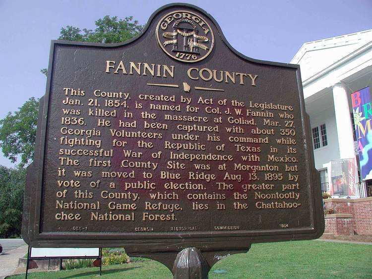
Fannin County was founded in 1854. The county is named for Georgia native James W. Fannin, who fought and died during the Texas Revolution.
Geography
According to the U.S. Census Bureau, the county has a total area of 392 square miles (1,020 km2), of which 387 square miles (1,000 km2) is land and 5.2 square miles (13 km2) (1.3%) is water. It has a mountainous terrain.
The Toccoa River, which rises in adjacent Union County, flows northward across Fannin County into Tennessee, where it becomes the Ocoee River. Blue Ridge Lake, created in the 1930s by the completion of Blue Ridge Dam (now operated by the Tennessee Valley Authority), spans a substantial stretch of the river in the northern part of the county.
The vast majority of Fannin County is located in the Ocoee River sub-basin of the Middle Tennessee-Hiwassee basin. A very small northeastern portion of Fannin County is located in the Hiwassee River sub-basin of the same Middle Tennessee-Hiwassee basin. Illustrating that watershed boundaries and county boundaries have little in common, Fannin County's southernmost corner is located in the Etowah River sub-basin in the ACT River Basin (Coosa-Tallapoosa River Basin), while two slivers of the county's southwestern area are located in the Coosawattee River sub-basin of the same larger ACT River Basin. Finally, a western portion of the county is located in the Conasauga River sub-basin of the ACT River Basin.
Adjacent counties
National protected area
Major highways
2000 census
As of the census of 2000, there were 19,798 people, 8,369 households, and 6,008 families residing in the county. The population density was 51 people per square mile (20/km²). There were 11,134 housing units at an average density of 29 per square mile (11/km²). The racial makeup of the county was 99.9% White, 0.2% Black or African American, 0.1% Native American, 0.2% Asian, 0.05% Pacific Islander, 0.0% from other races, and 0.0% from two or more races. 0.0% of the population were Hispanic or Latino of any race.
There were 8,369 households out of which 25.90% had children under the age of 18 living with them, 59.80% were married couples living together, 8.90% had a female householder with no husband present, and 28.20% were non-families. 25.60% of all households were made up of individuals and 12.80% had someone living alone who was 65 years of age or older. The average household size was 2.35 and the average family size was 2.80.
In the county, the population was spread out with 20.90% under the age of 18, 7.00% from 18 to 24, 24.90% from 25 to 44, 28.20% from 45 to 64, and 19.00% who were 65 years of age or older. The median age was 43 years. For every 100 females there were 93.50 males. For every 100 females age 18 and over, there were 90.80 males.
The median income for a household in the county was $30,612, and the median income for a family was $35,258. Males had a median income of $28,728 versus $21,246 for females. The per capita income for the county was $16,269. About 10.20% of families and 12.40% of the population were below the poverty line, including 14.10% of those under age 18 and 14.20% of those age 65 or over.
2010 census
As of the 2010 United States Census, there were 23,682 people, 10,187 households, and 7,016 families residing in the county. The population density was 61.2 inhabitants per square mile (23.6/km2). There were 16,207 housing units at an average density of 41.9 per square mile (16.2/km2). The racial makeup of the county was 97.1% white, 0.4% black or African American, 0.3% Asian, 0.3% American Indian, 0.7% from other races, and 1.2% from two or more races. Those of Hispanic or Latino origin made up 1.8% of the population. In terms of ancestry, 18.6% were Irish, 13.3% were American, 11.5% were English, and 9.5% were German.
Of the 10,187 households, 25.1% had children under the age of 18 living with them, 55.2% were married couples living together, 9.5% had a female householder with no husband present, 31.1% were non-families, and 27.1% of all households were made up of individuals. The average household size was 2.31 and the average family size was 2.77. The median age was 48.3 years.
The median income for a household in the county was $34,145 and the median income for a family was $41,422. Males had a median income of $34,875 versus $27,097 for females. The per capita income for the county was $21,103. About 12.2% of families and 16.2% of the population were below the poverty line, including 23.0% of those under age 18 and 13.8% of those age 65 or over.