
 | ||
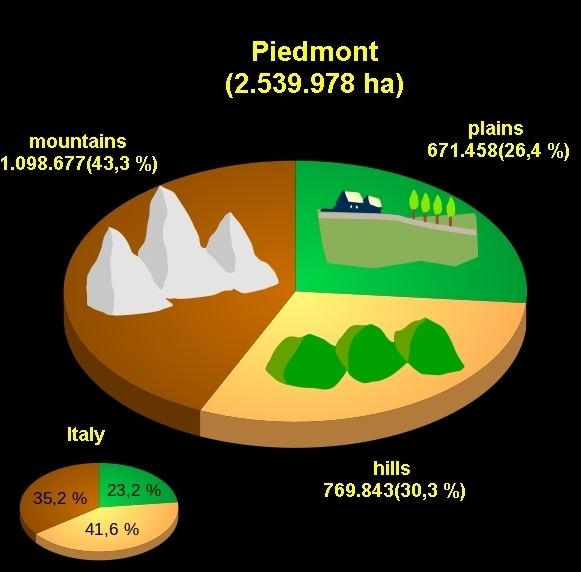
The Geography of Piedmont is that of a territory predominantly mountainous, 43.3%, but with extensive areas of hills which represent 30.3% of the territory, and of plains (26.4%).
Contents
To the north and to the west Piedmont is surrounded by the Alps, to the south by the Apennines, and to the east by the Po plain.
To the west Piedmont borders with France, to the north with Valle d'Aosta and Switzerland, to the east with Lombardy and Emilia Romagna, and to the south with Liguria.
Piedmont is the second largest of the 20 administrative regions of Italy, after Sicily. It is broadly contiguous with the upper part of the drainage basin of the river Po which rises from the slopes of Monviso in the west of the region and is Italy’s largest river. The Po collects all the waters provided within the semicircle of mountains (Alps and Apennines) which surround the region on three sides.
From the highest peaks the land slopes down to hilly areas, (not always, though, sometimes there is a brusque transition from the mountains to the plains) and then to the upper, and then the lower Pianura Padana. The boundary between the first and the second is characterised by risorgive, springs typical of the pianura padana which supply fresh water both to the rivers and to a dense network of irrigation canals.
Lago Maggiore and the line of the rivers Ticino and Sesia separate Piemont from Lombardy.
The countryside, then, is very varied: one passes from the rugged peaks of the massifs of Monte Rosa and of Gran Paradiso (national park), to the damp rice paddies of the Vercellese and Novarese; from the gentle hillsides of the Langhe and of Monferrato to the plains, often polluted and studded with a mixture of farms and industrial concerns.
Mountains
Principal mountains:
Valleys
As Piedmont is bounded to the north and to the west by the Alps, and to the south by the Apennines it is rich in valleys of very varied dimensions. There follows a list of some of the valleys of the region starting at the north of the boundary with Lombardy and proceeding anti-clockwise:
Rivers
The largest river in Piedmont is the Po. Other important rivers, in order of their mean rate of discharge, include:
Lakes
The principal lakes of Piedmont are: