
Prominence 673 m | Elevation 3,302 m | |
 | ||
Listing Alpine mountains above 3000 m Easiest route from Colle Ramiere and NW ridge Similar Rognosa di Sestriere, Rocca Bianca, Grand Queyron, Pic de Rochebrune, Bric Bouchet | ||
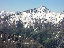
2014 09 23 punta ramiere mt 3303
The Punta Ramiere (in Italian) or Bric Froid (in French) is a mountain in the Cottian Alps belonging to the department of Hautes-Alpes (FR) and the province of Turin (IT). It's the highest peak of the long stretch of the Po/Rhone water divide starting from the Aiguille de Scolette (north) and ending with the Monviso group (south).
Contents
- 2014 09 23 punta ramiere mt 3303
- Map of Punta Ramiere 05460 AbriC3A8s France
- Punta ramiere
- Geography
- SOIUSA classification
- Access to the summit
- Nature conservation
- Maps
- References
Map of Punta Ramiere, 05460 Abri%C3%A8s, France
Punta ramiere
Geography
The Ramiere is the tripoint at which the borders of the Italian comunes of Sauze di Cesana and Cesana and the French commune of Abries meet.
The geodetic point of the Italian Military Geographic Institute named Punta Ramiere (code 066104) is defined on the top of the mountain.
SOIUSA classification
According to SOIUSA (International Standardized Mountain Subdivision of the Alps) the mountain can be classified in the following way:
Access to the summit
The easiest route for the summit starts from Colle Ramiere (Ramiere pass, 3,007 m) and reaches the mountain top by its northwestern ridge. The pass can be attained by foothpat from the Thuras valley (Cesana Torinese) or the Argentiera valley (Sauze di Cesana).
Nature conservation
The Punta Ramiere is located on the northern border of the French regional nature park of Queyras (Parc naturel régional du Queyras ), established in 1977.