
 | ||
Tour findo gask ridge roman site
The Gask Ridge is the modern name given to an early series of fortifications, built by the Romans in Scotland, close to the Highland Line. Modern excavation and interpretation is pioneered by the Roman Gask Project and directors Birgitta Hoffmann and David Woolliscroft.
Contents
Name
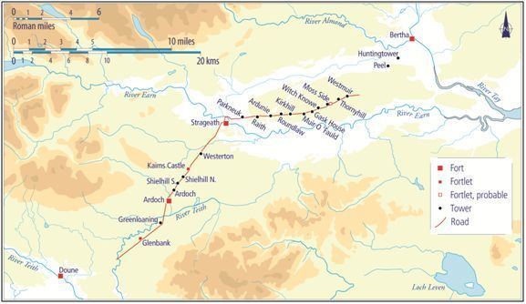
The name "Gask Ridge" refers to the 10-mile (16 km) ridge of land to the north of the River Earn in Perthshire. In Scottish Gaelic, a gasg is a projecting tail or strip of land. In the early 20th century, a line of Roman signal-towers (or watch-towers) was discovered along this ridge between the Roman forts of Strageath and Bertha.
History
The Gask Ridge system was constructed sometime between 70 and 80 CE. Construction on Hadrian's Wall was started 42 years after completion of the Gask Ridge (from 122 to 130 CE), and the Antonine Wall was started just 12 years after completion of Hadrian's Wall (from 142 to 144 CE). Although the Gask Ridge was not a wall, it may be Rome's earliest fortified land frontier. The fortifications approximately follow the boundary between Scotland's fertile Lowlands and mountainous Highlands, in Perth and Kinross and Angus. The later Hadrian's Wall and Antonine Wall were further south, and, by taking advantage of the heavily indented coastline of Great Britain, were considerably shorter.
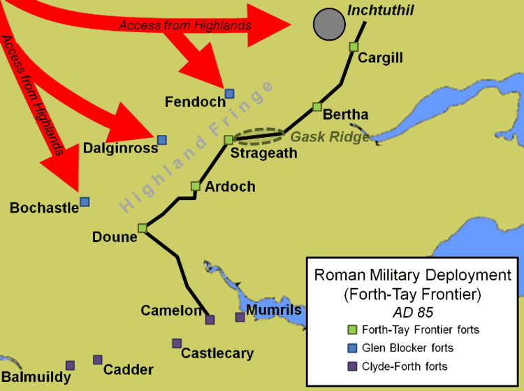
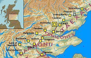
The principal forts of the Gask Ridge frontier system were (from south to north): Camelon, Drumquhassle, Malling/Menteith, Doune, Glenbank (fortlet), Bochastle, Ardoch, Kaims Castle (fortlet), Strageath, Dalginross, Bertha, Fendoch, Cargill (fort and fortlet), Inchtuthil (Legionary fortress), Cardean, Inverquharity (fortlet), and Stracathro.
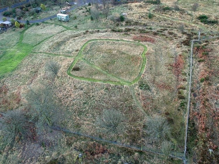
Glenblocker forts
The forts of Drumquhassle, Menteith/Malling, Bochastle, Doune, Dalginross and Fendoch in the southwest are collectively referred to as the Glenblocker forts in the older literature; they are also called the Highland line forts. Glenblocker refers to their location at the exit of some of the glens (narrow valleys) or straths (a broad valleys), and can thus supervise traffic.
All of the forts were originally built during the Flavian occupation in Scotland. A broader group consists of:
It is debatable, whether Cardean, Stracathro and Doune should be listed among these, as they are sited further away from their respective traffic corridors, although fulfilling the same function.
Role
It has traditionally been thought that these forts were meant to prevent invasions out of the Scottish Highand into Roman held territory. This may have been their aim, working in cooperation with the other forts on the Gask Ridge and along Strathmore, as only the legionary fortress of Inchtuthil with 5000-6000 soldiers would have been strong enough to deal with a major incursion. The smaller forts were more likely to serve as a disincentive to small scale raiding parties etc.,
The relationship between the Glenblocker forts and the Gask Ridge has in the past been seen to represent a staged withdrawal. More recent research suggests that the three elements are actually part of the same frontier system, stretching roughly from Loch Lomond to Montrose. The Glenblocker forts in this scenario controlled access to major valleys in the frontier area, which actually loop back into the frontier area, rather than link to the Iron Age settlement concentration further north. Their role as an effective block to invasion is doubtful, as their situation would have allowed supervision, but their manpower was not strong enough to deter anything but small scale cattle raids.
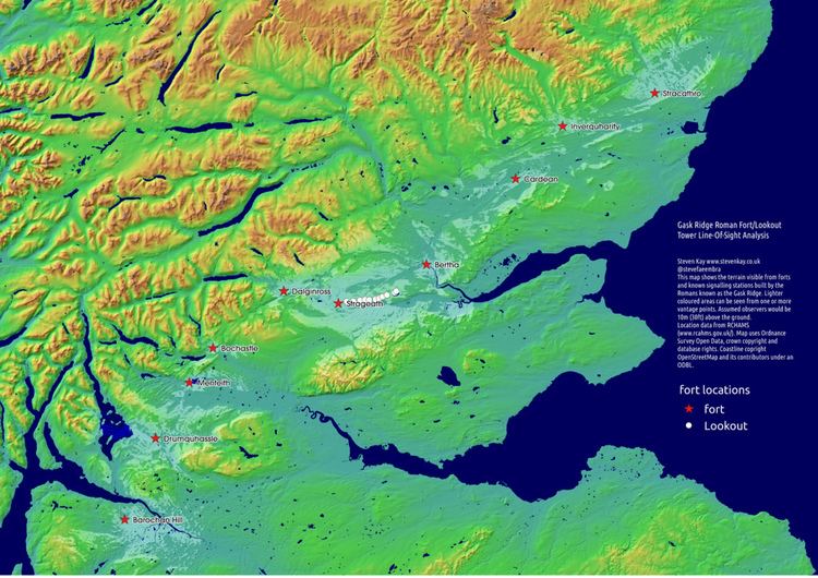
Only the legionary fortress at Inchtuthil, conveniently situated for access into Braemar and the areas beyond, is large enough to have functioned as a major defence, or springboard for future invasions. The Gask Road and the towers alongside it in this scenario guarded the strategically important link to the harbours at the Firths of Tay and Forth and the Southern part of the province.
Tacitus writes in De vita Iulii Agricolae that Agricola was fighting in the area in around 80 CE. The latest coinage dates from 86 CE. This would suggest that the forts were occupied for at most 6 years. However, recent archaeology has shown that many of the forts comprising the Gask Ridge were rebuilt over time, sometimes twice, without any evidence of destruction through warfare. Further digs may cast some light on this apparent contradiction.
The forts of Ardoch, Strageath and Bertha on the Gask Road, as well as the forts of Cargill in Strathmore and the Glenblocker fort of Dalginross have also produced Antonine material attesting to a reuse of the sites contemporary with the Antonine Wall.
In the Severan period the area was also under Roman occupation, which focused on the Legionary fortress of Carpow Roman Fort downstream from Perth.
North of the Gask Ridge
The permanent sites discussed above are complemented by a series of large marching camps stretching from the Scottish Lowlands into Aberdeenshire and the Inverness area (where there are possible Roman forts like Cawdor). The Roman legions in the 1st century established a chain of very large forts at Ardoch, Strageath, Inchtuthil, Battledykes, Stracathro and Raedykes, taking the Elsick Mounth on the way to Normandykes, before going north to Glenmaillen, Bellie, Balnageith and Cawdor.
In the 1990s researchers have discovered new possible Roman Fortifications north of Inverness and the Moray Firth. The most important are Tarradale and Portmahomack. These are still being studied by RCAHMS in order to verify that they are really Roman structures. Several reconstructions of their chronological role exist at present.