
Area 31 km² | Total islands 14 Population 1,641 (2007) Archipelago Polynesia | |
 | ||
Islands | ||
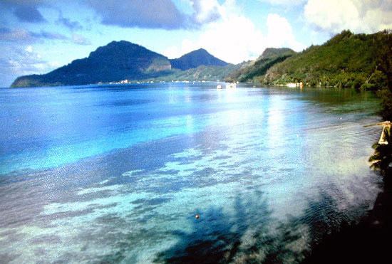
French polynesia gambier islands island hopping with honey
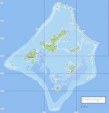
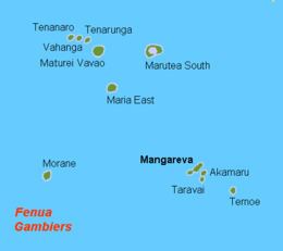
The Gambier Islands or Mangareva Islands (French: Îles Gambier or Archipel des Gambier) are a populated (1641 people), small (30 km2 or 12 sq mi) group of islands, remnants of a caldera along with islets on the surrounding fringing reef, in French Polynesia, located at the southeast terminus of the Tuamotu archipelago. They are generally considered a separate island group from Tuamotu both because their culture and language (Mangarevan) are much more closely related to those of the Marquesas Islands, and because, while the Tuamotus comprise several chains of coral atolls, the Gambiers are of volcanic origin with central high islands. Because of their proximity, the Acteon Group, and the nearby atolls of Maria Est, Morane, Marutea Sud and Temoe (23°20′46″S 134°28′28″W), all permanently uninhabited, are sometimes included among the Gambiers.
Contents
- French polynesia gambier islands island hopping with honey
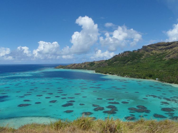
- Motu tauna gambier islands french polynesia 2014
- Administration
- Geography
- History
- Effects of French nuclear testing on the Gambiers
- References
Motu tauna gambier islands french polynesia 2014
Administration
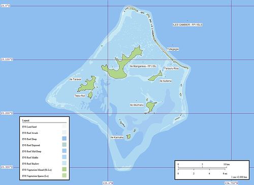
The commune of Gambier is made up of the Gambier Islands (with uninhabited Temoe Atoll 40 km southeast of the main Gambier group), the uninhabited Acteon Group to the northwest (Matureivavao, Tenararo, Tenarunga, Vahanga), and the also uninhabited atolls of Marutea Sud, Maria Est and Morane. This group of islands and atolls covers an area of 35 km².
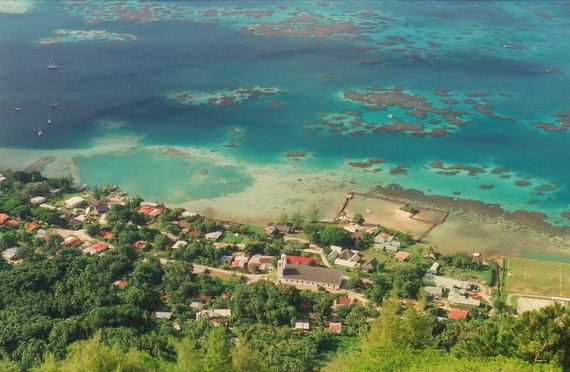
Although these archipelagos are administered as a single municipality (commune), the main village is Rikitea, on the largest island of Mangareva.
The commune of Gambier comprises:
The Gambier Islands (Gambier), together with the islands in the eastern part of the Tuamotus (Anaa, Fangatau, Hao, Hikueru, Makemo, Napuka, Nukutavake, Puka-Puka, Reao, Tatakoto and Tureia), form Îles Gambier et Tuamotu Est, one of the 6 electoral districts (circonscriptions électorales) for the Assembly of French Polynesia (Assemblée de la Polynésie française).
Together with the Tuamotus, the Gambier Islands form Îles Tuamotu-Gambier (French: (les) (Îles) Tuamotu-Gambier or officially la subdivision administrative des (Îles) Tuamotu-Gambier), one of the five primary administrative divisions (subdivisions administratives) of French Polynesia.
Geography
The Gambier Islands proper have an enclosing coral reef which is broken by only three passages to the open sea. Besides Mangareva, the other notable high islands of the group are Akamaru, Angakauitai, Aukena, Kamaka, Kouaku, Makapu, Makaroa, Manui, Mekiro and Taravai. These are primarily of volcanic origin. A number of others are actually coral islands, hence of secondary volcanic origin, including Papuri, Puaumu, Totengengie and the Tokorua group.
The islands proper are located at 23°09′S 134°58′W and are approximately 31 km² (12 mi²) in area. The total population in 2007 was 1,641. The primary town is Rikitea, located on Mangareva, as is the highest point in the Gambiers, Mt. Duff, rising to 441 metres (1,447 ft) along that island's south coast.
The more distant atolls of the Gambiers in the broad sense are all uninhabited.
History
Approximately from the 10th to the 15th centuries, the Gambiers hosted a population of several thousand people and traded with other island groups including the Marquesas, the Society Islands and Pitcairn Islands. However, excessive logging by the islanders resulted in almost complete deforestation on Mangareva, with disastrous results for the islands' environment and economy. The folklore of the islands records a slide into civil war and even cannibalism as trade links with the outside world broke down, and archaeological studies have confirmed this. Today, the islands can support a population of only a few hundred.
In 1834, the French Picpus priests Honoré Laval and François Caret with their assistant Columba Murphy founded a Roman Catholic mission in the Gambiers. After their success here, they moved to Tahiti in 1836.
Mangareva along with its dependencies in the Gambier Islands were ruled by a line of kings and later regents that ruled until the French formally annexed the islands in 1881. A French protectorate was requested on 16 February 1844 by King Maputeoa but was never ratified by the French government. On 4 February 1870, Prince Regent Arone Teikatoara and the Mangarevan government formally withdrew the protectorate request and asked the French to not intervene in the kingdom's affairs. After Father Laval was removed to Tahiti, the native government changed their stance and an agreement between the native government and the French colonial authority in Tahiti was signed reaffirming the protectorate status on 30 November 1871. The Gambier Islands were finally annexed on 21 February 1881 under Prince Regent Bernardo Putairi and approved by the President of France on 30 January 1882.
Effects of French nuclear testing on the Gambiers
The Gambiers served as a logistical staging base for French nuclear testing activity in Mururoa, approximately 400 kilometers away. During this time, the French military dragged a chain through some of the coral reef beds to cut a wider and deeper channel for deep draft vessels. Higher rate of intoxications by ciguatera were subsequently recorded.
French military vessels visited the area (as of 1993) every six months collecting specimens of water, food, human hair and other material, as well as taking detailed accounts of births, deaths and other demographic events, presumably for on-going research into the effects of the nuclear testing. The results of this research are not published.
According to French Polynesian doctors who have worked in the area, considerably higher than normal incidences of cancer and thyroid problems are found amongst Polynesians who live near the Moruroa atoll.